
Tag Archives: national

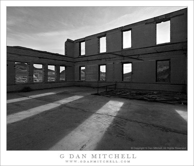
Schoolhouse Ruins, Rhyolite

Schoolhouse Ruins, Rhyolite

Schoolhouse Ruins, Rhyolite. Rhyolite, Nevada. April 1, 2009 © Copyright 2009 G Dan Mitchell – all rights reserved.

Morning sunlight shine through the window frames of the ruins of the abandoned schoolhouse in the ghost town of Rhyolite Nevada, near Death Valley National Park.

The ghost town of Rhyolite, Nevada is located just east of the boundary of Death Valley National Park, along the edge of the Amargosa Valley, and not far from Beatty, Nevada, which itself is close to the Nevada Test Site. Put all of that together and you have the potential for a bit of a spooky place!

Rhyolite was a short-lived mining town in the early 1900s, when it apparently was home to thousands of people who streamed to this forsaken landscape to find silver. The town was eventually abandoned – although some mining still takes place in the area – but a good number of the larger buildings are still there, in various states of decay. An old train station that looks pretty fancy is fenced off to keep us out, but you can walk (respectfully and carefully!) among many other old structures including the old school house that is the subject of this photograph.

I’ve been out here a number of times and dawn is my favorite time to photograph here. The light makes it to many of the old ruins very shortly after actual sunrise, and there is a moment of often beautiful light at this time. From Rhyolite the hills inside Death Valley National Park are visible to the west and above the nearer hills you can see Telescope Peak, the highest point in the park at over 11,000′ elevation.

The school (like a few of the other ruins) looks like it must have been a very large and robust structure. Even though the roof and the second floor are gone, almost all of the exterior walls still stand and don’t show any immediate signs of incipient collapse. On this morning I made a series of photographs from just inside one of the “doorways” of the school with a wide-angle lens. I selected and shared a few of them back in 2009, but I recently went back to my original raw files and decided to try this one in black and white.

G Dan Mitchell Photography
About | Flickr | Twitter | FacebookGoogle+ | 500px.com | LinkedIn | Email

Text, photographs, and other media are © Copyright G Dan Mitchell (or others when indicated) and are not in the public domain and may not be used on websites, blogs, or in other media without advance permission from G Dan Mitchell.

(Basic EXIF data may be available by “mousing over” large images in posts when this page is viewed on the web. Leave a comment if you want to know more.)
Trail Junction, Redwood Forest and Ferns

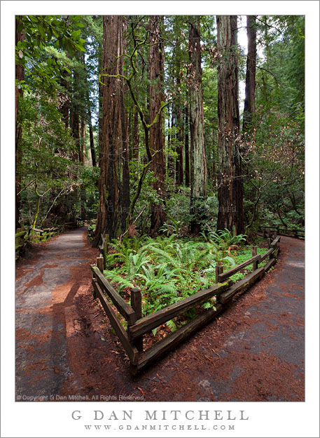
Trail Junction, Redwood Forest and Ferns

Trail Junction, Redwood Forest and Ferns. Muir Woods National Monument, California. March 8, 2009. © Copyright 2009 G Dan Mitchell – all rights reserved.

A bed of ferns grows at a trail junction under deep redwood forest cover at Muir Woods National Monument.

This photograph was made in the late winter of 2009, during that time of the year when the redwood forest is still very wet and cool, but when flowers are blooming and spring is clearly on the way. The location is along the very popular (and often quite busy) main trail along the creek through the central part of the park. No doubt I had to wait a bit for the combination of these beams of light and no other visitors on the trail!

G Dan Mitchell Photography
About | Flickr | Twitter | FacebookGoogle+ | 500px.com | LinkedIn | Email

Text, photographs, and other media are © Copyright G Dan Mitchell (or others when indicated) and are not in the public domain and may not be used on websites, blogs, or in other media without advance permission from G Dan Mitchell.

(Basic EXIF data may be available by “mousing over” large images in posts when this page is viewed on the web. Leave a comment if you want to know more.)

Sunset, Lower McCabe Lake, Shepherds Crest, and Virginia Canyon

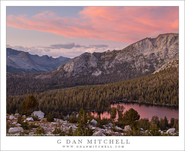
Sunset, Lower McCabe Lake, Shepherds Crest, and Virginia Canyon

Sunset, Lower McCabe Lake, Shepherds Crest, and Virginia Canyon. Yosemite National Park, California. September 19, 2011. © Copyright 2011 G Dan Mitchell – all rights reserved.

Afternoon storm clouds clear from the sunset sky above Lower McCabe Lake, Shepherds Crest, and Virginia Canyon, Yosemite National Park.

With this photograph I get to tell another of the “serendipitous photograph” stories that seem to keep coming up in my work. In this case, we had been camped near the lake in the lower area of the photograph for several days, getting to know the place and having time to carefully photograph various areas nearby. On a previous evening we had climbed to a second lake a few hundred feet higher than the “main” lake, from which one of our group decided to traverse a nearby slope. He ended up at another alpine lake that looked interesting, and the next morning others went with him to visit it. I didn’t, because I had some other things that I wanted to photograph in morning light and because I had a hunch that the light might turn out to be more interesting in the evening, mainly because the area of the lake was open to the west and, therefore, the evening light.

So in the evening, after our typical very early dinner, I departed on a walk to the upper lake that my friends had visited that morning, wandering around “our” lake and through the surrounding forest to pick up a rocky ramp that ascended toward the lake. However, I apparently missed a turn somewhere. I finished the main part of the climb and apparently should have turned left immediately – but I continued on straight ahead and soon found myself in a little meadowy area with a rather steep bunch of rocks between me and my goal. I finally found a circuitous route up a series of ramps, but now it was getting too close to sunset and my turn-around time, so I had to retrace my steps without getting to the lake.

I returned to the small meadow and made a few photographs there, then headed back toward the route by which I had ascended. Despite not making the lake, one of my main goals had been to get up high to photograph the surrounding terrain at sunset, especially since earlier in the day large thunderclouds had been building to the east and creating the possibility of some very special evening light. As I descended the upper part of the “ramp,” the pre-sunset colors started to light up and I quickly found a spot with a good vantage point to view this in several directions. Among the last photographs I made as the light started to fade was the series including this image. (It is actually a composite of two exposures – one for the very bright and saturated clouds and another for the darker shadows down near that lake.) Beyond the lake is the left end of rocky Shepherds Crest and even further in the distance is Virginia Canyon and then the Sierra crest.

G Dan Mitchell Photography
About | Flickr | Twitter | FacebookGoogle+ | 500px.com | LinkedIn | Email

Text, photographs, and other media are © Copyright G Dan Mitchell (or others when indicated) and are not in the public domain and may not be used on websites, blogs, or in other media without advance permission from G Dan Mitchell.

(Basic EXIF data may be available by “mousing over” large images in posts when this page is viewed on the web. Leave a comment if you want to know more.)

Corn Lily Leaves, Autumn

Corn Lily Leaves, Autumn

Corn Lily Leaves, Autumn. Yosemite National Park, California. September 18, 2011. © Copyright 2011 G Dan Mitchell – all rights reserved.

Corn lily plants take on autumn colors in the Sierra Nevada, Yosemite National Park.

The corn lily plants are among my favorite markers of the passage of the short high Sierra summer season. When the high country first opens and water is everywhere, the first shoots look almost like unhusked ears of corn as they come up in wet areas. (I don’t think this is where the plant gets its name – more on that in a moment.) They quickly grow to several feet tall, clustered in thick bunches, as the mosquito season arrives – and at this time they are incredibly lush and green. At this time they are also a favorite subject for photographers. A few seem to sprout much taller than others and produce clusters of white flowers. Then as August wears on and the soil begins to dry the plants also begin to lose their lush quality and brown areas appear and perhaps some spots and holes appear in the leaves. Often by the end of the month I can find some that are starting to turn one of several shades: golden-yellow, tan, or very dark brown verging on black. By mid September few healthy looking plants remain and the stalks (which look very much like corn stalks) begin to fall over to the ground.

It hardly matters where this particular group of corn lily plants was growing, so I’ll just say that they were within a few minutes of our camp site. I can hardly ever pass up the opportunity to try to photograph this plant, no matter which stage of its life it is currently going through. These had fallen over and were rapidly losing what remained of their green color.

G Dan Mitchell Photography
About | Flickr | Twitter | FacebookGoogle+ | 500px.com | LinkedIn | Email

Text, photographs, and other media are © Copyright G Dan Mitchell (or others when indicated) and are not in the public domain and may not be used on websites, blogs, or in other media without advance permission from G Dan Mitchell.

(Basic EXIF data may be available by “mousing over” large images in posts when this page is viewed on the web. Leave a comment if you want to know more.)