Tag Archives: pebble

Cove and Wave

Cove and Wave
Cove and Wave

Cove and Wave. Point Lobos State Reserve, California April 21, 2013. © Copyright 2013 G Dan Mitchell – all rights reserved.

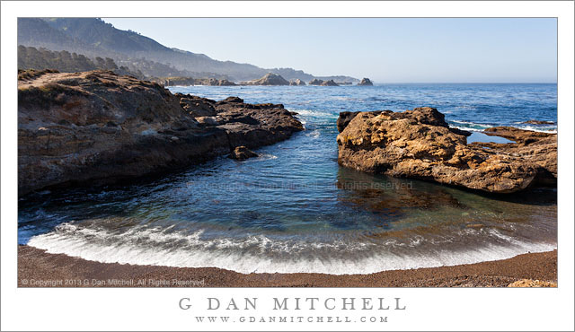
A wave washes into a small cove and onto a pebble beach along California’s coastline south of Monterey

I went down to the Monterey, Carmel, and upper Big Sur coast on what seemed like the first warm-season day of the year. I have probably mentioned before that I prefer the off-season for photography – that time of year when there are storms, giant waves, clouds, rain, cold, and all sorts of interesting conditions. As odd as it may sound, I tend to almost stay away from the coast when the weather becomes too nice! (Of course, there is always fog. And in the summer along the Pacific coast, I do mean “always.”) At the first place I stopped to photograph I was feeling a bit of the letdown from the beautiful morning… but as I got out of my car and stood there in shirt-sleeve weather, warm and no wind, and looked out over the slightly misty coastline I started to feel a bit better about warm weather. :-)

A bit later I headed back toward Point Lobos, where I found a bit more surf than I might have expected, and the high tide had brought the water in close to the shoreline. Here I set up right at the edge of a low bluff above this pebble-filled beach, put a wide-angle lens on the camera, and made some photographs of the near-perfect curve of the waves entering the cove and washing up onto the beach, with sea stacks further down the coast line.

G Dan Mitchell is a California photographer and visual opportunist whose subjects include the Pacific coast, redwood forests, central California oak/grasslands, the Sierra Nevada, California deserts, urban landscapes, night photography, and more.
Blog | About | Flickr | Twitter | FacebookGoogle+ | 500px.com | LinkedIn | Email

Text, photographs, and other media are © Copyright G Dan Mitchell (or others when indicated) and are not in the public domain and may not be used on websites, blogs, or in other media without advance permission from G Dan Mitchell.

Stones, Stained Granite

Stones, Stained Granite

Stones, Stained Granite. Yosemite National Park, California. September 15, 2011. © Copyright 2011 G Dan Mitchell – all rights reserved.

Granite stones rest on glaciated slab of stained granite near the Tuolumne River, Yosemite National Park.

Scared you, didn’t I? Thought I was going to miss posting a daily photograph, right? Yeah, both of you… ;-)

In any case, I may have mentioned previously that I’m a sucker for Sierra granite, especially the glaciated kind that is found almost everywhere you go in Yosemite National Park, from the Valley to areas surrounding the very highest peaks. (Some of the highest peaks escaped the glaciation themselves, but that’s a longer story for another time.) For me, some combination of glaciated granite slabs, a few “erratic” boulders (“erratics” being boulders moved from their source and left behind by retreating glaciers), some trees, and a bit of meadow grass, perhaps with a stream or lake nearby shouts “Sierra Nevada.”

This photograph does not include all of these Sierra ingredients but it does include the granite. I photographed this small bit of granite slab along a section of the Tuolumne River than runs through the back-country during a week-long backpack trip this past September. Something about the arrangement and color of the four larger stones against the water-stained underlying rock with its complex textures interested me. A lot of what is in the frame may not be visible in the small jpg version posted here, but there is a lot of detail in the frame: the texture or rock, crystal structures on some of the stones, several smaller pebbles, even a bit of dried pine needle.

G Dan Mitchell is a California photographer whose subjects include the Pacific coast, redwood forests, central California oak/grasslands, the Sierra Nevada, California deserts, urban landscapes, night photography, and more.
Blog | About | Flickr | Twitter | FacebookGoogle+ | 500px.com | LinkedIn | Email

Text, photographs, and other media are © Copyright G Dan Mitchell (or others when indicated) and are not in the public domain and may not be used on websites, blogs, or in other media without advance permission from G Dan Mitchell.

Branch on Playa, Panamint Valley

Branch on Playa, Panamint Valley

Branch on Playa, Panamint Valley. Death Valley National Park, California. March 31, 2011. © Copyright G Dan Mitchell – all rights reserved.

A lone branch lies across dried mud on the playa of Panamint Valley, Death Valley National Park.

First, a story about the location. My first visit to Death Valley was sometime in the late 1990s, when the “hiking and biking” club at my kids’ middle and high school did a trip there. The club is a long and interesting story that I don’t have time or space to describe here fully. Suffice it to say that the teacher, “Mr. Hodges,” had for decades taken kids on amazing outdoor adventures throughout the western United States every year, and that the trip that year was to involve visits to several places in the park and then a backpacking trip down to the Valley from up in the Teakettle Junction vicinity. This may sound like a crazy thing to do with a bunch of school kids, but the group had a record of success. I was along as a parent chaperone since my oldest son was a participant in the trip.

The “readers digest” version of the story of the trip is that, as is often the case near the beginning of April, we encountered an astonishing range of weather conditions. Early on it snowed and the wind blew at gale force levels. This forced us to abandon our initial backpacking plans after we had already camped overnight near Teakettle Junction, and to head back down to the Valley. We readjusted our plans and decided that we might still be able to do an overnight hike down the length of the upper Valley and (leaving out a bunch of intervening adventures in this narrative) we arrived at Stovepipe Wells and set up camp… just in time for a tremendous dust storm to blow in. The next morning the “bus” arrived that was to take the kids and a few of the chaperones home (the rest of us were in a truck carrying tons – literally – of gear on the roof rack and in a trailer) and we headed up to cross Towne Pass. It turned out that the “bus” (which was more or less a large airport shuttle-type van) was ill-equipped for these conditions and after struggling up the pass and then racing down the other side, the transmission blew out at the bottom of the descent into Panamint Valley. Those of us in the truck pulling the trailer arrived a few minutes later to find a group of scared kids and parents who had just experienced more excitement than they wanted.

I have a strong visual memory of “Mary,” one of the parents, who had just had a bit too much excitement walking quietly north away from the road and across this playa. Ever since that time, this place that most people would probably blow right past, has almost always warranted a stop as I passed by on my way out of the Valley. This trip was no exception. I left my camera gear in the car and just walked a ways out onto the playa. As I walked, even though I had been certain that my photography for this trip was finished, I started noticing some of the small details on the playa… and I went back to my car to get my camera, then returned and made a few hand-held exposures of some of these small subjects.

G Dan Mitchell Photography | Flickr | Twitter | Facebook | Email
Text, photographs, and other media are © Copyright G Dan Mitchell (or others when indicated) and are not in the public domain and may not be used on websites, blogs, or in other media without advance permission from G Dan Mitchell.

Shoreline Plants and Sandstone, Weston Cove

Shoreline Plants and Sandstone, Weston Cove

Shoreline Plants and Sandstone, Weston Cove. Point Lobos State Reserve, California. October 23, 2010. © Copyright G Dan Mitchell – all rights reserved.

Plants grow in cracks in the sandstone along the shore of Weston Cove, Point Lobos State Reserve, California.

On this visit to Point Lobos, a place I photograph frequently, I wasn’t quite sure what conditions I would encounter. A Pacific weather front was approaching and I thought that I might encounter dismal, overcast conditions – but I was surprised to find it mostly sunny when I arrived. Even better, high, thin clouds were approaching the coast line and soon muted the direct sunlight, which made photographing these shoreline rock formations a more reasonable possibility during the late morning.

I’m pretty familiar with Point Lobos in general at this point, having visited the place from the time I was a child. I’m especially familiar with Weston Beach (or “cove,” as I like to think of it), with its circular shape, protective rock barrier, angled sandstone edges, and large pebbly “sand.” But as familiar as I am with this location, I almost alway find something new if I look around carefully enough, and these plants growing in the angular cracks in the sandstone were new to me.

This photograph is not in the public domain and may not be used on websites, blogs, or in other media without advance permission from G Dan Mitchell.

G Dan Mitchell Photography | Twitter | Friendfeed | Facebook | Facebook Fan Page | Email