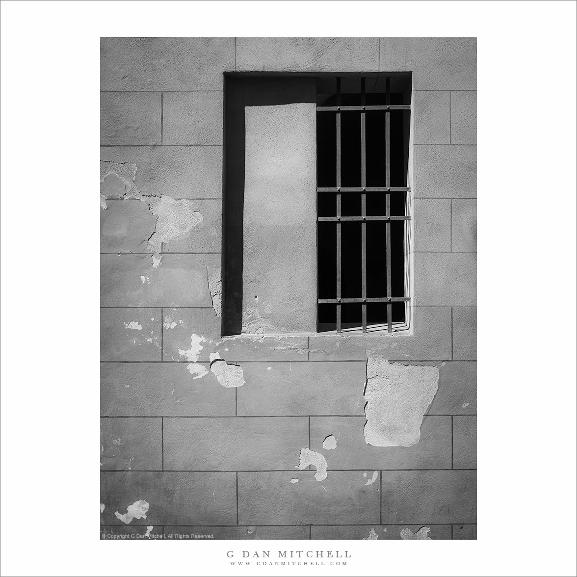
“Wall And Barred Window” — A barred window and weahtered wall in Italian summer sun, Siena.
This photograph of a small section of an otherwise nondescript wall along a Siena, Italy street was triggered, I suppose, by my fascination with patterns, textures, and forms — and by how they come together. You might not know it from the photograph, but the sun was very bright a the time. When I looked at the result later on, I first realized that color played virtually no role in the photograph and that I had more control over that light with a monochrome rendition.
As is often typical of me, I did not even note what the building was. (I might be able to figure it out from some other photographs, but it may not be important.) Part of what I like about the subject is the the perfect symmetry and form of the lines on the wall and the square window is dissonant with the weathered and peeling wall surface and the slightly bent grate over the mysterious window.
G Dan Mitchell is a California photographer and visual opportunist. His book, “California’s Fall Color: A Photographer’s Guide to Autumn in the Sierra” is available from Heyday Books, Amazon, and directly from G Dan Mitchell.
A lone branch lies across dried mud on the playa of Panamint Valley, Death Valley National Park.
First, a story about the location. My first visit to Death Valley was sometime in the late 1990s, when the “hiking and biking” club at my kids’ middle and high school did a trip there. The club is a long and interesting story that I don’t have time or space to describe here fully. Suffice it to say that the teacher, “Mr. Hodges,” had for decades taken kids on amazing outdoor adventures throughout the western United States every year, and that the trip that year was to involve visits to several places in the park and then a backpacking trip down to the Valley from up in the Teakettle Junction vicinity. This may sound like a crazy thing to do with a bunch of school kids, but the group had a record of success. I was along as a parent chaperone since my oldest son was a participant in the trip.
The “readers digest” version of the story of the trip is that, as is often the case near the beginning of April, we encountered an astonishing range of weather conditions. Early on it snowed and the wind blew at gale force levels. This forced us to abandon our initial backpacking plans after we had already camped overnight near Teakettle Junction, and to head back down to the Valley. We readjusted our plans and decided that we might still be able to do an overnight hike down the length of the upper Valley and (leaving out a bunch of intervening adventures in this narrative) we arrived at Stovepipe Wells and set up camp… just in time for a tremendous dust storm to blow in. The next morning the “bus” arrived that was to take the kids and a few of the chaperones home (the rest of us were in a truck carrying tons – literally – of gear on the roof rack and in a trailer) and we headed up to cross Towne Pass. It turned out that the “bus” (which was more or less a large airport shuttle-type van) was ill-equipped for these conditions and after struggling up the pass and then racing down the other side, the transmission blew out at the bottom of the descent into Panamint Valley. Those of us in the truck pulling the trailer arrived a few minutes later to find a group of scared kids and parents who had just experienced more excitement than they wanted.
I have a strong visual memory of “Mary,” one of the parents, who had just had a bit too much excitement walking quietly north away from the road and across this playa. Ever since that time, this place that most people would probably blow right past, has almost always warranted a stop as I passed by on my way out of the Valley. This trip was no exception. I left my camera gear in the car and just walked a ways out onto the playa. As I walked, even though I had been certain that my photography for this trip was finished, I started noticing some of the small details on the playa… and I went back to my car to get my camera, then returned and made a few hand-held exposures of some of these small subjects.
Morning clouds fill the sky above the Manifold at Zabriskie Point, Death Valley National Park.
I posted a monochrome version of this photograph yesterday, so there is perhaps a bit less to say about it in this post. To recap briefly, this is a photograph I made over three years ago during a spring visit to Death Valley NPS. This was a bit of a different morning for photographing at Zabriskie Point, if I recall correctly. Usually, photographing here is pretty straightforward – and once you’ve shot it a couple times in “normal” conditions, there is a basic pattern to the progression of light that becomes fairly (though perhaps not totally) clear. Normal conditions here basically mean perfectly clear skies with the sun coming up to the left from the perspective of this photograph or behind in some of the other familiar shots that include Manley Beacon – and light that sequentially illuminates subjects beginning with the highest peaks of the Panamint Range across the Valley and gradually working down into the Valley and finally to the rugged shapes at Zabriskie Point itself.
But clouds can change everything. If I am going to shoot at Zabriskie, I watch for conditions that will bring them. I will generally not stop there if it is “another beautiful clear sunrise” at Zabriskie. (If you haven’t been there before, you should stop and take in this stunning scene, but I’m often looking for something a bit different.) While the results in clear conditions are relatively predictable, they are not at all as predictable when there are clouds. You can end up with something very special… or with a drab, flat, and gray scene. But that’s the thing about special conditions – they wouldn’t be special if they were predictable and frequent!
Thinking back to this morning, my recollection is that it may have been one of those when I arrived to think, “Oh, boy, clouds!” – only to think a bit later, “I wish those clouds would move and give me some light!” I recall some bits of dawn light that were mostly blocked by the clouds. But the very clouds that blocked the hoped-for first dawn light thoughtfully assembled themselves into these impressive forms just a bit later, at right about the time that the warm side-light was getting down into the rugged folds of the Manifold and Gower Wash.
This photograph is not in the public domain and may not be used on websites, blogs, or in other media without advance permission from G Dan Mitchell.
Morning clouds fill the sky above the Manifold at Zabriskie Point, Death Valley National Park.
This photograph is not in the public domain and may not be used on websites, blogs, or in other media without advance permission from G Dan Mitchell.
Recently I’ve been going over some of my Death Valley photographs, and as I do so I discover a few that “missed the cut” the first time around but which I kind of like now when I see them a few years later. This photograph was made in 2007, on a spring morning when beautiful clouds filled the sky above Zabriskie Point and Death Valley. I have versions of this photograph in both black and white and color – I like both, though the effect is quite different. (I’ll post the color version as soon as tomorrow.)
I’ve referred to the striking central feature of the “badlands” above Gower Wash – the hill with the curving gullies and the darker material along the top – as “the Manifold” for a few years. I know I saw this label applied to the feature somewhere, but I cannot find the source now. In any case, it seems deserving of its own name, and “the Manifold” works for me.
One more observation… I have written elsewhere about my attitude toward photographing iconic scenes – an Zabriskie Point is certainly iconic! It is a bit of a long, complicated story, but this photograph illustrates part of my philosophy. I will not always bother to stop and photograph such a site, having seen many beautiful mornings (and a few evenings) there. But I do watch for special or unusual conditions, and when they occur I may well head to an icon like Zabriskie to try to make a photograph that is unlike the usual images.
Since I am in the process of reviewing many Death Valley photographs, don’t be too surprised if a few more older photos from that location show up here soon.
Photographer and visual opportunist. Daily photos since 2005, plus articles, reviews, news, and ideas.
Manage Consent
To provide the best experiences, we use technologies like cookies to store and/or access device information. Consenting to these technologies will allow us to process data such as browsing behavior or unique IDs on this site. Not consenting or withdrawing consent, may adversely affect certain features and functions.
Functional
Always active
The technical storage or access is strictly necessary for the legitimate purpose of enabling the use of a specific service explicitly requested by the subscriber or user, or for the sole purpose of carrying out the transmission of a communication over an electronic communications network.
Preferences
The technical storage or access is necessary for the legitimate purpose of storing preferences that are not requested by the subscriber or user.
Statistics
The technical storage or access that is used exclusively for statistical purposes.The technical storage or access that is used exclusively for anonymous statistical purposes. Without a subpoena, voluntary compliance on the part of your Internet Service Provider, or additional records from a third party, information stored or retrieved for this purpose alone cannot usually be used to identify you.
Marketing
The technical storage or access is required to create user profiles to send advertising, or to track the user on a website or across several websites for similar marketing purposes.