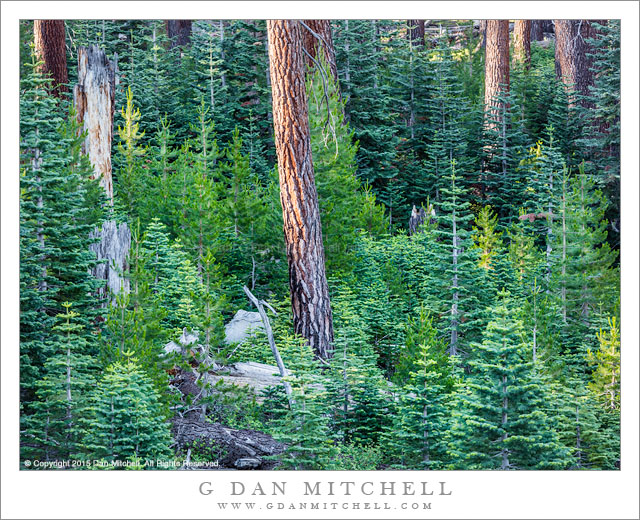
Tag Archives: road

Cottonwood Trees, Gravel Road

Cottonwood Trees, Gravel Road
A gravel road passes cottonwood trees in fall color, Capitol Reef National Park, Utah

Cottonwood Trees, Gravel Road. Near Capitol Reef National Park, Utah. October 22, 2014. © Copyright 2014 G Dan Mitchell – all rights reserved.

A gravel road passes cottonwood trees in fall color, Capitol Reef National Park, Utah

By the time I made this photograph, the day almost seemed to be winding down. We had gotten up before dawn and made our way to the start of a long gravel road, where we paused to photograph as the sun came up. It was one of those almost unplanned moments — no specific landscape in mind, but there was the rising sun, so we stopped and found that we could photograph a range of subjects in that light. Then we headed on down this road, eventually arriving at one of our possible goals, where we took a hike to a high place with a panoramic view.

By now it was getting on toward the middle of the day — mostly the non-shooting hours for photographers in many cases — so we headed back the way we came. As we drove we came to this flat with good-sized cottonwood trees spread along a small gravel road heading off toward the uplifted terrain of Capitol Reef National Park. The autumn color of these trees was irresistible… so we didn’t resist! We stopped, got out, photographed for a while , and then were back on the road.


G Dan Mitchell is a California photographer and visual opportunist. Blog | About | Flickr | Twitter | FacebookGoogle+ | 500px.com | LinkedIn | Email


All media © Copyright G Dan Mitchell and others as indicated. Any use requires advance permission from G Dan Mitchell.

Sandstone Cliffs, Autumn

Sandstone Cliffs, Autumn
Evening light on the autumn sandstone landscape of Capitol Reef National Park, Utah

Sandstone Cliffs, Autumn. Capitol Reef National Park, Utah. October 20, 2014. © Copyright 2014 G Dan Mitchell – all rights reserved.

Evening light on the autumn sandstone landscape of Capitol Reef National Park, Utah

I began this fall season visit to Utah in the far southwest corner of the state, making Kanab my base for the first few days. There I explored various valleys and canyons, mostly improvising an itinerary as the mood struck me. I returned there to a few places I had visited in the past and also visited a few new places. After a few days here I took a back-route up to Capitol Reef where I would meet up with my friend and fellow photographer David Hoffman.

I arrived at Capitol Reef in the afternoon, found Dave’s campsite (he had arrived earlier) and set up my tent. As I recall, we were unable to resist the lure of the nearby place selling home-made pies, and it wasn’t until late in the day that we decided to make a quick run for some sunset light. We found it quickly — the location of our campground is just out of sight to the right around the bend in the road running up this valley. Because the landscape tilts up to the west here, the sunset seems to come a bit earlier than I would expect, and we were barely in time of catch this light before the valley fell into shadow.


G Dan Mitchell is a California photographer and visual opportunist. Blog | About | Flickr | Twitter | FacebookGoogle+ | 500px.com | LinkedIn | Email


All media © Copyright G Dan Mitchell and others as indicated. Any use requires advance permission from G Dan Mitchell.

Titus Canyon

Titus Canyon
Titus Canyon

Titus Canyon. Death Valley National Park, California. April 1, 2015. © Copyright 2015 G Dan Mitchell – all rights reserved.

Titus Canyon narrows, Death Valley National Park

In something of a departure for me… I have named a location. Enjoy it while it lasts! ;-) The lower portion of this canyon is one of the popular destinations in Death Valley National Park, and with good reason. This section is very narrow and deep, and aside from the lack of red colored rock it might remind one in some ways of similar canyons in other places such as the Southwest. There are essentially two ways to get to this section. More than once I’ve driven to the canyon entrance, loaded up a pack with camera gear and water, and walked in. This is a great way to experience the lower canyon, which is the area with the most impressive canyon walls and narrow sections. I always see much more when I’m on foot, and there are a lot of subtle things to look for in this part of the lower canyon.

The alternative way to get here involves a fair amount of driving on a road that is rough enough that it could make some drivers uncomfortable. (It is not a place for low-slung suburban vehicles, to be sure.) The one-way road through the canyon begins in the higher country of the Amargosa Valley near the eastern boundary of the park. It crosses the flat desert terrain as it heads toward the mountains and soon begins to twist and turn through valleys, up slopes, and over ridges. A few sections might test the nerves of drivers not used to such roads, especially the sections just before and after Red Pass. Once over the pass the road drops into the canyon and begins its descent toward the Valley. Near the end the road passes through the section that you could hike into from below, a section that seems like a very improbable place for an automobile roadway — and this photograph shows part of that segment of the trip.


G Dan Mitchell is a California photographer and visual opportunist whose subjects include the Pacific coast, redwood forests, central California oak/grasslands, the Sierra Nevada, California deserts, urban landscapes, night photography, and more.
Blog | About | Flickr | Twitter | FacebookGoogle+ | 500px.com | LinkedIn | Email

Text, photographs, and other media are © Copyright G Dan Mitchell (or others when indicated) and are not in the public domain and may not be used on websites, blogs, or in other media without advance permission from G Dan Mitchell.

Long Valley Ranch Building

Long Valley Ranch Building
“Long Valley Ranch Building” — Long Valley ranch building with autumn morning mist

This is the same ranch that is pictured in the photograph I posted yesterday, though this photograph was made two years earlier. The ranch is out on the less-traveled back roads of Long Valley, not far from the resort town of Mammoth Lakes. That said, there isn’t anything remotely resort-like about this place, which gives every appearance of being a working ranch with cattle and horses and run-down outbuildings.

I love this area in the fall when the temperatures drop and the steam from the geothermal sources of hot water can rise into the morning light. In the right conditions, small columns of mist rise all over the valley. This particular spot has a lot of water, most notably nearby Hot Creek, which is, uh, hot. As I do so often, here I chose to photograph almost directly into the morning sun, which creates and extremely bright and luminous quality in the mist and which places the shaded side of the building toward the camera in the lower part of the frame.


Leave a comment or question using the form. (Click the title to see the full article and to comment if you are viewing it on the home page.)

G Dan Mitchell is a California photographer and visual opportunist. His book, “California’s Fall Color: A Photographer’s Guide to Autumn in the Sierra” (Heyday Books) is available directly from him. Blog | Bluesky | Mastodon | Substack Notes | Flickr | Email

All media © Copyright G Dan Mitchell and others.