Tag Archives: summer

Fin Dome, Storm Clouds

Fin Dome, Storm Clouds

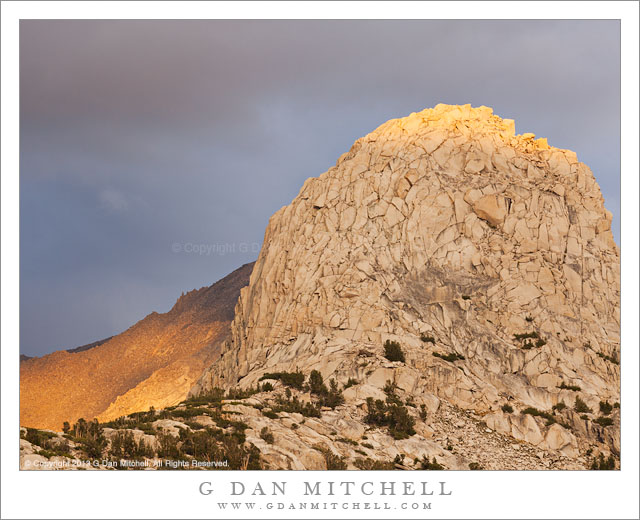
Fin Dome, Storm Clouds. Kings Canyon National Park, California. September 14, 2013. © Copyright 2013 G Dan Mitchell – all rights reserved.

Last rays of sunset light illuminate the fractured summit of Fin Dome and the Sierra crest on a stormy late-summer evening

During a week of beautiful days in the King Canyon National Park High Sierra back-country, this may have been one of the most compelling. The day began with interesting clouds and light, eventually evolved into light showers mixed with sun shine, and as sunset approached it cleared enough to give us rainbows, dramatically dark storm clouds, and golden hour light on the surrounding upper peaks.

This dome is a familiar landmark for many who pass along a section of the John Muir Trail not far from where we photographing, though that familiar view shows the opposite side of this feature. Although I was very close to it during the many days we spent photographing here, the face of the dome was often no all that photogenic. During the day the flat light did not complement it, and it is difficult to see how to compose an effective image of the thing from very close and right below it. However, on this evening we had wandered off to another location not far away, where there were many lakes and ponds, beautiful small meadows and granite formations, and more expansive views of the surrounding landscape. Shortly after we arrived there it began to sprinkle on us and we could see heavier showers distributed around the wider terrain. As sunset approached, the clouds thinned a bit over our position and the sun began to occasionally slant in from the west below the clouds, casting light beams that traversed the landscape to our east. I missed a few moments of beautiful light on this dome before I finally realized that this was a situation likely to repeat itself – and I stopped and waited for the next illumination from the west to arrive, here contrasting the warm sunlight on the peak with the darker storm clouds further to the east.

G Dan Mitchell is a California photographer and visual opportunist whose subjects include the Pacific coast, redwood forests, central California oak/grasslands, the Sierra Nevada, California deserts, urban landscapes, night photography, and more.
Blog | About | Flickr | Twitter | FacebookGoogle+ | 500px.com | LinkedIn | Email

Text, photographs, and other media are © Copyright G Dan Mitchell (or others when indicated) and are not in the public domain and may not be used on websites, blogs, or in other media without advance permission from G Dan Mitchell.

Desert Sky, Negit Island

Desert Sky, Negit Island

Desert Sky, Negit Island. Mono Lake, California. August 5, 2013. © Copyright 2013 G Dan Mitchell – all rights reserved.

Mono Lake and dark Negit Island beneath a vast and cloud-filled summer sky

Mono Lake still seems like a somewhat mysterious place to me. Although I’m familiar with parts of it, having gone by and to it for many years on Sierra trips and having photographed there many times, I find it hard to quite get my mind around it in the same way that I can with many other places. There are probably several factors that contribute to this. First, it is obviously an absolutely huge place. While I can see the far side of the lake and the mountains beyond, they are a great distance away, as I’ve realized when traveling just part way around it – so I have looked at much of it but I have not directly experienced that much of it close up. Second, we feel that we know the chief features of this lake very well – they are, I suppose, the lowering water level of this close-off basin lake, its tremendous size, the mineral-filled water, and the famous tufa formations. But a bit more time, even only that time that I’ve spent there that is mostly secondary to “Sierra time,” and it starts to be clear that these things are not the whole story.

Some years ago, when photographing the tufas around dawn, mostly when almost no one else was around, I began to catch on to the fact that things like the sounds of flocks of birds, the immense distances on land and – especially – in the huge sky, the wind, and the deep quiet of the place have more to do with its character than the tufas. Often when I stop there now I do not go to the tufas at all, instead perhaps expanding my knowledge of other areas of the lake and surrounding country. This photograph was made from above the lake, in a location where I could look slightly down on the water, which better shows its expanse, and on the dark shape of volcanic Negit Island. But I chose to include them primarily not for their own value but rather to anchor that vast sky with its building afternoon clouds.

G Dan Mitchell is a California photographer and visual opportunist whose subjects include the Pacific coast, redwood forests, central California oak/grasslands, the Sierra Nevada, California deserts, urban landscapes, night photography, and more.
Blog | About | Flickr | Twitter | FacebookGoogle+ | 500px.com | LinkedIn | Email

Text, photographs, and other media are © Copyright G Dan Mitchell (or others when indicated) and are not in the public domain and may not be used on websites, blogs, or in other media without advance permission from G Dan Mitchell.

Dusk, Earth-Shadow, Oaks and Grass

Dusk, Earth-Shadow, Oaks and Grass

Dusk, Earth-Shadow, Oaks and Grass. Sierra Nevada Foothills, California. August 25, 2013. © Copyright 2013 G Dan Mitchell – all rights reserved.

The earth’s dusk earth shadow rises behind the folds of an oak and grass-covered Sierra Nevada foothill ridge on a late-summer evening

We had been in Mariposa, along the road heading towards Yosemite Valley, to meet up with friends and do various other fun things. As is often the case, at one point the conversation turned toward the photographic possibilities for later in the day. As the horrendous “Rim” fire was burning a few ridges over along the boundaries of the park, one thought was to find a high viewpoint and try to photograph the huge smoke clouds and the light from the flames during the dusk hours. A suggestion was offered by a person who knows the area concerning a gravel back-road to the top of an area ridge from which a good view might be obtained, so we decided to give that a try. It was a beautiful early evening – no smoke here – as we drove through oak and grass-covered hills below Mariposa to pick up this route and then ascended toward the ridge to turn off on the gravel road. From the junction we could see columns of smoke from burning forest to our north, but there was also a pretty clear “No Trespassing” sign posted along the road… so we decided that we should double-check our directions before risking a citation, and we headed back down the mountain.

The alternative plan had been to simply photograph the beautiful foothills themselves as the day came to an end. In this area there are many beautiful valleys of rolling hills covered with dry grassland and oak forests that sometimes thin to individual trees. We headed along a little back road and soon arrived at our main route shortly before the last sunlight was about to fade. Driving as we looked, we finally stopped at a turnout right after the sun had dropped below the horizon, where we could see the boundary between the last pink color in the sky and the rising blue line of the earth’s shadow. I used a long lens to make a small number of exposures shooting across the hillside patterns towards an oak-topped ridge with the dusk sky beyond.

G Dan Mitchell is a California photographer and visual opportunist whose subjects include the Pacific coast, redwood forests, central California oak/grasslands, the Sierra Nevada, California deserts, urban landscapes, night photography, and more.
Blog | About | Flickr | Twitter | FacebookGoogle+ | 500px.com | LinkedIn | Email

Text, photographs, and other media are © Copyright G Dan Mitchell (or others when indicated) and are not in the public domain and may not be used on websites, blogs, or in other media without advance permission from G Dan Mitchell.

About the Yosemite “Rim” fire… and more

UPDATE and a NOTE:

Update: Shortly after I posted this, my reports on highway 120 through the park via the Tuolumne Meadows area  were rendered incorrect/outdated by way of an updated announcement from the park service as follows:

“Beginning at 12:00pm on Wednesday, August 28th, Tuolumne Meadows and the High Sierra will only be accessible via Highway 120 East through Lee Vining.  The Tioga Rd/Hwy 120 East will be temporarily closed between White Wolf Lodge and the Big Oak Flat Rd./Hwy 120 West at Crane Flat; the closure is estimated to be 3 to 4 days.  Tuolumne Meadows Lodge, the High Sierra Camps, and Tuolumne Meadows and Porcupine Flat campgrounds all remain open.”

Basically, this means that you will not be able to use highway 120 as a route across the Sierra until further notice. I’m not surprised – in fact, I’ve been somewhat surprised that the road remained open this long. Apparently the following URL is also a good source of updates from the park: http://www.yosemitepark.com/yosemite-fire-update.aspx

Note: All of which brings me back to my original statement that I don’t have inside information on this fire, and that anyone traveling to the area needs to check official sources for conditions updates. I will likely not update this page as things change, so the information posted here should be regarded as potentially being out of date!

My original post follows…

A few people have asked me for information about the “Rim” fire which started not far from Groveland near highway 120, and which is currently burning along the northwest boundary of Yosemite National Park, generally moving east and north toward the highway 108 area. While I know much of this area fairly well from many years (decades, actually) of visits, I do not have any inside information about the fire itself, nor am I an expert on wildfires. One good source of (limited but objective) information is the Stanislaus National Forest Rim Fire Incident web page. A map on this page is a quite amazing source of information, especially when combined with some familiarity with the area and a reading of various written reports. (The version on the main page seems to be based on Google Maps, and allows you to scroll around and zoom in.) Lots of folks who live and work in the area are sharing updates on the usual social media sites. The Mariposa Gazette is another local news source.

The fire started on August 17 more or less midway between Groveland and the  northwest park entrance and not far off of the highway 120 corridor near the Rim of the World area overlooking the canyon of the Tuolumne River. (Highway 120 is a common route for entry to the park from the west and northwest, and it connects via Tuolumne Meadows and Tioga Pass to the east side of the Sierra at the town of Lee Vining.) The spread of the fire at first was somewhat quick, which is no surprise given the extremely dry conditions in the Sierra following a second very dry winter and almost no real precipitation since late 2012. Then, between about August 20 and 23, the fire exploded, expanding  very quickly to cover a huge area generally to the east and north of the starting point, with the fire generally racing northeast but also spreading to the north and south. Continue reading About the Yosemite “Rim” fire… and more