
Tag Archives: sunset

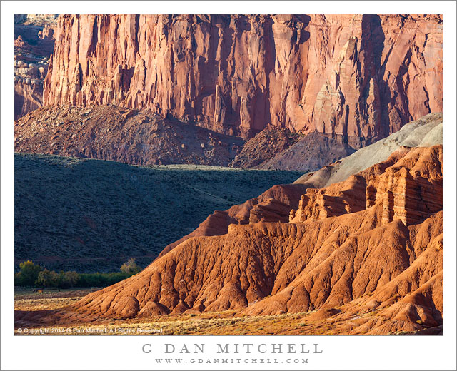
Redrock Country, Near Fruita

Redrock Country, Near Fruita
Cliffs and eroded towers near Fruita, Capitol Reef National Park

Redrock Country, Near Fruita. Capitol Reef National Park, Utah. October 20, 2014. © Copyright 2014 G Dan Mitchell – all rights reserved.

Cliffs and eroded towers near Fruita, Capitol Reef National Park

I’m a sucker for juxtapositions of mountains and cliffs, and sunlit and shadowed surfaces. (In fact, “juxtaposition” is a word I think about a lot when making photographs.) This part of the world provides these juxtapositions with a vengeance. Everywhere in the red rock country of the Southwest there are sandstone walls, lined up, building one on top of the other, standing in front of and behind each other, layered with eroded rock and soil, standing above valleys and beyond lower ridges.

We had only a brief time to photograph on this first afternoon in Capitol Reef National Park. I had arrived in the middle of the afternoon and then busied myself with setting up a tent and a few other camp chores, plus catching up on the news with my friend Dave. By the time all of these important things had been taken care of the sun was rapidly dropping toward the horizon, so we quickly headed to a nearby area to see what sort of late-day light we could find. Literally within minutes of leaving our campground (which is just to the right of the shadowed trees visible in the lower part of the photograph) we came upon this intense and saturated late-day light, with shadows starting to stretch across the valley and the low foreground ridges.


G Dan Mitchell is a California photographer and visual opportunist. Blog | About | Flickr | Twitter | Facebook | Google+ | 500px.com | LinkedIn | Email


All media © Copyright G Dan Mitchell and others as indicated. Any use requires advance permission from G Dan Mitchell.
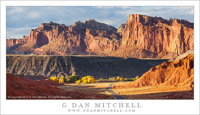
Sandstone Cliffs, Autumn

Sandstone Cliffs, Autumn
Evening light on the autumn sandstone landscape of Capitol Reef National Park, Utah

Sandstone Cliffs, Autumn. Capitol Reef National Park, Utah. October 20, 2014. © Copyright 2014 G Dan Mitchell – all rights reserved.

Evening light on the autumn sandstone landscape of Capitol Reef National Park, Utah

I began this fall season visit to Utah in the far southwest corner of the state, making Kanab my base for the first few days. There I explored various valleys and canyons, mostly improvising an itinerary as the mood struck me. I returned there to a few places I had visited in the past and also visited a few new places. After a few days here I took a back-route up to Capitol Reef where I would meet up with my friend and fellow photographer David Hoffman.

I arrived at Capitol Reef in the afternoon, found Dave’s campsite (he had arrived earlier) and set up my tent. As I recall, we were unable to resist the lure of the nearby place selling home-made pies, and it wasn’t until late in the day that we decided to make a quick run for some sunset light. We found it quickly — the location of our campground is just out of sight to the right around the bend in the road running up this valley. Because the landscape tilts up to the west here, the sunset seems to come a bit earlier than I would expect, and we were barely in time of catch this light before the valley fell into shadow.


G Dan Mitchell is a California photographer and visual opportunist. Blog | About | Flickr | Twitter | Facebook | Google+ | 500px.com | LinkedIn | Email


All media © Copyright G Dan Mitchell and others as indicated. Any use requires advance permission from G Dan Mitchell.
Lenticular Clouds and Ridge

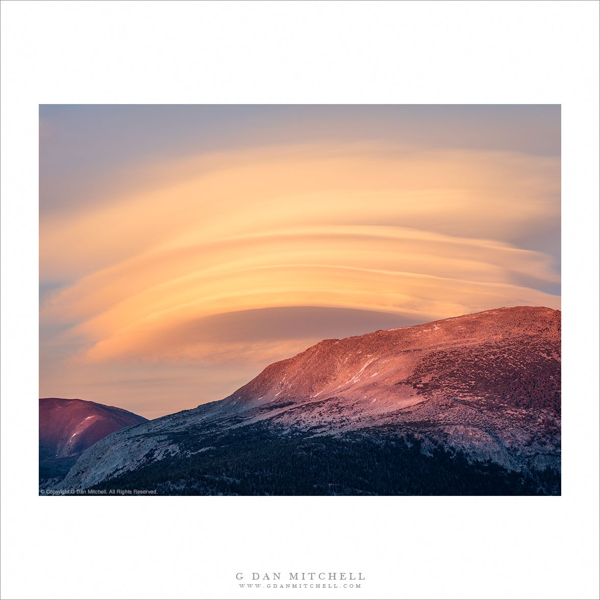
“Lenticular Clouds and Ridge” — A series of lenticular clouds build above the Sierra Nevada crest at sunset

This scene was a visual benediction at the end of a very long June day in Yosemite National Park. We began all the way over in Oakhurst, where we had been the previous evening to attend the artist reception for an exhibit at Stellar Gallery that includes eight of my photographs. Afterwards we shared a late-night Mexican dinner with friends and fellow photographers. The next morning we got up relatively early (but not all that early by photography standards!), grabbed a quick breakfast, and headed out of town with a general plan to photograph along Tioga Pass Road.

We drove through most of the morning good light as we headed into the park, climbed past the turnoff to Glacier Point Road, descended briefly to the Valley, climbed Big Oak Flat Road, and finally turned east onto Tioga Pass Road. We briefly stopped once or twice along the way, including a bit of photography at Tenaya Lake, then finally stopping at Tuolumne Meadows for lunch. We explored a bit near Tioga Pass before descending to Lee Vining and then making a quick trip up Lundy Canyon before returning to Lee Vining. We then headed back up toward Tioga Pass, timing this leg to arrive back in the high country at the time when shadows would lengthen and the color of the light begin to warm. We photographed a bit just below the pass, but when we noticed a spectacular lenticular cloud building beyond the crest we decided to head to Tuolumne Meadows, where we though the cloud might be more visible and have more interesting foreground. We photographed there until the light left the meadow, and then started to think about the long drive back to the Bay Area. Not more than a couple of minutes down the road we looked back and saw what we sort of expected, namely the intense sunset color on the tops of the ridges of the Sierra crest and the spectacular cloud. We quickly stopped, set up cameras and tripods, and spent a few moments photographing this beautiful final light of the day.


G Dan Mitchell is a California photographer and visual opportunist. His book, “California’s Fall Color: A Photographer’s Guide to Autumn in the Sierra” (Heyday Books) is available directly from him.

G Dan Mitchell: Blog | Bluesky | Mastodon | Substack Notes | Flickr | Email


All media © Copyright G Dan Mitchell and others as indicated. Any use requires advance permission from G Dan Mitchell.

Dark Hills, Death Valley

Dark Hills, Death Valley

Dark Hills, Death Valley. Death Valley National Park, California. April 1, 2015. © Copyright 2015 G Dan Mitchell – all rights reserved.

Dark hills contrast with surrounding salt flats and alluvial fans

I know that “dark hills” is not a very poetic description for this landscape… but it does seem, at least, to be accurate! These formations have intrigued me for a few years, and I’ve been surprised to be able to photograph them all alone — despite visiting them regularly, I have never encountered another person there. I’m not sure why, except that there are some better known icons nearby, and perhaps they attract all of the others in the area.

In the past I tried to find out more about the source of the formations and my recollection (which I was unable to re-verify this time) is that they are the result of some kind of ancient tufa-like deposits formed on the bottom of the lake that once filled the basin that is now Death Valley. Their darker color contrasts strikingly with the surrounding terrain, and the material of the mounts has a finely layered quality. This example sits on a small playa where pooling water seems to have left salt deposits behind, though similar forms can also be found in slightly higher terrain nearby. In the evening the low light from the west angles across these mounds and makes their textures and curves a bit more visible.


G Dan Mitchell is a California photographer and visual opportunist whose subjects include the Pacific coast, redwood forests, central California oak/grasslands, the Sierra Nevada, California deserts, urban landscapes, night photography, and more.
Blog | About | Flickr | Twitter | Facebook | Google+ | 500px.com | LinkedIn | Email

Text, photographs, and other media are © Copyright G Dan Mitchell (or others when indicated) and are not in the public domain and may not be used on websites, blogs, or in other media without advance permission from G Dan Mitchell.