Tag Archives: tower

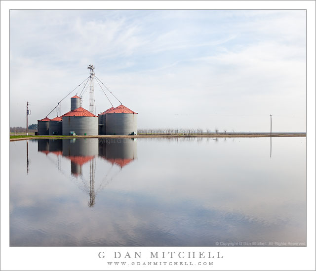
Flooded Field and Farm Structures

Flooded Field and Farm Structures

Flooded Field and Farm Structures. Central Valley, California. January 23, 2011. © Copyright G Dan Mitchell – all rights reserved.

Agricultural facilities and Central Valley sky reflected in the surface of a flooded field.

This area turned out to be fun place to shoot. It is along a fairly nondescript road that branches off from Interstate 5 midway between Stockton and Sacramento and eventually dead-ends against a levee lining the Cosumnes River. I had been told that it is a good place to look for migratory birds – and, indeed, it is. Although it was hard to see them due to the very thick tule fog when I first arrived shortly after dawn, when I came back in the early afternoon the sky had cleared and the many fields, vineyards, and ponds along the road were filled with waterfowl.

I first saw this set of “structures” (silos? Being a “city boy,” I’m not certain of the right way to describe cylindrical storage facilities like this) as I drove out from Interstate 5 towards the river. They make for quite a striking sight – they are quite large, they are tall and the tower above is even taller, the brick colored roofs stand out against the other colors, and they are reflected in the still water of surrounding ponds. It was on my way back past them that I saw the view over this pond. I had just stopped to make another photograph of the ponds and I thought I was finished for the day – my thoughts were getting back to the highway and heading home. But I decided to walk down to a levee that let me place the structures and their reflections across the water and surround the image of the building and the thin horizon line with sky above and below.

G Dan Mitchell Photography | Flickr | Twitter | Facebook | Email
Text, photographs, and other media are © Copyright G Dan Mitchell (or others when indicated) and are not in the public domain and may not be used on websites, blogs, or in other media without advance permission from G Dan Mitchell.

Trees Atop the Rostrum

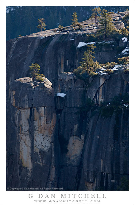
Trees Atop the Rostrum

Trees Atop the Rostrum. Yosemite National Park, California. January 15, 2011. © Copyright G Dan Mitchell – all rights reserved.

Sparse trees grow in granite slabs above steep granite cliffs in Lower Yosemite Valley.

(Note: After receiving some advice from a helpful reader – which was much appreciated! – I now know that this feature has a name. It is called “the Rostrum,” and I have retitled the photograph accordingly.)

I’ve seen these tree-topped columns and the granite slabs beyond many times when I’ve taken Crane Flat Road into the Valley. On my recent visit to Yosemite, photographing these trees in both early and late light was on my agenda, and I got myself into position to shoot them on two or three occasions.

At the right times of day – and there are at least two when this can work – the light slants across the top of the granite slabs and ledges at the top of these cliffs and catches the trees with side or back light. Below these upper slopes the vertical fluted forms of the cliffs drop nearly vertically to the Merced River canyon below. The cliffs themselves are in what I might describe as lower Yosemite Valley – think of Crane Flat Road above Cascade Creek or the area well beyond the upper end of Wawona Tunnel. There is a lot of very interesting and imposing rock in this part of the Valley, though I think it may get overlooked a bit by comparison to the truly astonishing faces and domes and peaks of the Valley proper.

Since the light changes throughout the year, and especially because the point at which the sun sets moves north as the years moves from winter to summer, I want to come back and photograph this area again a bit later in the year when I think the potential for light later in the day might improve.  From my point of view, the ideal conditions might combine “golden hour” side light with shadows that reduce the detail on the forest covered slopes beyond – and without the bright snow patches that appear here. Of course, a fresh snowfall here might also be interesting…

I got a bit of a laugh out of one thing that happened when I made this photograph, though it is similar to similar situations I’ve had in the past. It is not at all unusual for lots of tourists to stop when they see a photographer with a big tripod and large lens at a pull-out along the road. I assume they think that if the photographer with the Fancy Equipment is stopping that there must be something there worth photographing. But sometime the photographer is pointing the camera in direction that must only confuse them. On this occasion I was in a spot with a classic and stunning view of distant Bridalveil Fall, and I’ll bet that many of those stopping thought they might try to duplicate my “shot of the falls.” But as they stopped and looked they may have wondered about me if they noticed that my lens was aimed at some seemingly nondescript spot perhaps 30% to the right of the fall…

G Dan Mitchell Photography | Flickr | Twitter | Facebook | Email
Text, photographs, and other media are © Copyright G Dan Mitchell (or others when indicated) and are not in the public domain and may not be used on websites, blogs, or in other media without advance permission from G Dan Mitchell.
Coit Tower, Fog

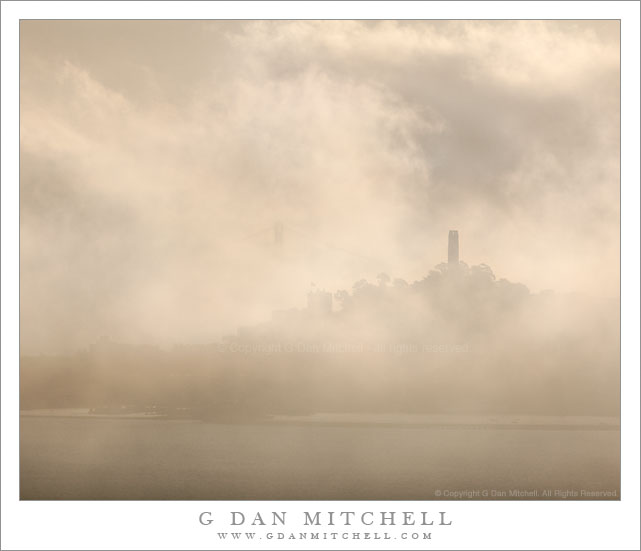
Coit Tower, Fog
Coit Tower, Fog

Coit Tower, Fog. San Francisco, California. December 16. 2010. © Copyright G Dan Mitchell – all rights reserved.

Swirling fog and mist engulf San Francisco’s Coit Tower and Telegraph Hill.

One more in this series of photographs of the San Francisco waterfront and downtown areas in brightly back-lit, early morning conditions in which the City was nearly obscured by drifting fog. All of the photographs in the series were made from a location near the north end of the Golden Gate Bridge, just a bit up the road into the Marin Headlands. Like several of the others, this one was shot with a 400mm focal length lens, pointing almost directly in the direction of the rising sun. For some of the exposures I had to stand a couple feet in front of the camera, at the maximum extension of my remote release cable, and carefully position my hand to shade the front element of the lens.

Here the fog has almost completely obscured Coit Tower at the top of Telegraph Hill. If you look very carefully to the left of Coit Tower you can barely make out the ghostly image of the top of one of the towers of the San Francisco Oakland Bay Bridge. It was my good fortune that a slightly less opaque section of the drifting fog momentarily framed the summit of Telegraph Hill.

This photograph is not in the public domain and may not be used on websites, blogs, or in other media without advance permission from G Dan Mitchell.
G Dan Mitchell Photography
Flickr | Twitter | Facebook Fan Page | Facebook | Friendfeed | Email

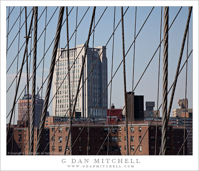
Brooklyn Bridge Cables, Lower East Side Buildings

Brooklyn Bridge Cables, Lower East Side Buildings

Brooklyn Bridge Cables, Lower East Side Buildings. New York, New York. August 19, 2010. © Copyright G Dan Mitchell – all rights reserved.

Buildings of the lower east side of Manhattan, seen through the cables of the Brooklyn Bridge.

My son kept suggesting a walk across – or at least on to – the Brooklyn Bridge, so when the weather finally cleared up on our last full day in New York City and we found ourselves wandering around Lower Manhattan near the entrance to the pedestrian walkway across the bridge, we really had no choice.

It is hard – perhaps impossible? – to make a truly new photograph of the bridge, at least for this first time photographer of this New York icon. I do have a few frames of the masses of cables ascending to the tower closest to Manhattan, a scene we’ve all seen before, and I probably won’t be able to resist posting at least one of them eventually

I have no idea whether or not a shot like this one is familiar to those who have seen more photos of the bridge than I have, but it wouldn’t surprise me if it is a typical view. In any case, I was fascinated by the dense web of cables, the fact that they are much thinner than bridge cables that I’m familiar with, and the appearance of the many buildings along the east short of Manhattan Island both north and south of the bridge.

This photograph is not in the public domain and may not be used on websites, blogs, or in other media without advance permission from G Dan Mitchell.
G Dan Mitchell Photography | Twitter | Friendfeed | Facebook | Facebook Fan Page | Email