
Tag Archives: view

White Rim, Colorado River Valley

White Rim, Colorado River Valley

White Rim, Colorado River Valley. Canyonlands National Park, Utah. October 10, 2012. © Copyright 2013 G Dan Mitchell – all rights reserved.

The Colorado River winds through rugged country beyond the White Rim, Canyonlands National Park

On our second visit to Canyonlands National Park (the first had been back in April of the same year, when we briefly visited the “Island in the Sky” highlands of the park) we were somewhat stymied by less than astonishing light. Overall the skies were sort of partly cloudy, but that “partly” portion seemed to line up almost perfectly with where we were, and from afternoon on a large mass of clouds sat above us and to the west. For this photograph, that might have actually been a bit of a blessing, in that trying to photograph the tremendously intricate and detailed landscape visible from the “Grand View” overlook in full sun at this time of day would have been challenging, to say the least. This landscape, lit that way, would have contained some extremely bright features along with very deep shadows in the canyons, and the result probably would not have been all that great. The clouds, however, somewhat mute the contrasty light, making the bright areas a bit less bright and allowing diffused light down into areas that would otherwise be dark. At least there was a bit of light on the buttes in the far distance at the upper edge of the frame.

This scene is one of those “iconic” views that, well, everyone photographs. Generally, I’m not that much about photographing icons. In fact, often when I go to places like this I try to not know what the iconic shots are or where to find them, preferring to instead just sort of guess, follow hunches, poke around, and see what I discover. This may not be the most effective way to find the “cool stuff” in a new location, but it does let me start to develop my own relationship with a landscape from the very beginning. So when we went into Canyonlands the first time I basically had almost no idea what I was “supposed” to see and photograph. (For example, I had no idea that iconic “Mesa Arch” is in this park – drove past the road to it and said, “Ah, that’s where Mesa Arch is!” And, no, I did not photograph it.) However, as we wandered about and looked at stuff, we somehow managed to end up at several of “those places” – especially the Green River overlook (which I now recognize as one of the iconic views of this park) and Grand View. In addition, I’ve often advised others to not eschew icons in certain situations. One, of course, is when you find yourself in front of such an icon and have never photographed it before. But another is when one visits a location for the first time and does not yet have a deeper knowledge of the place. For example, I’ll occasionally get asked by first time visitors to Yosemite or Death Valley (places where I shoot a lot) about where the “secret spots” are that not everyone shoots. I tell them that getting to know a place to such an extent that you can find, “see,” understand and photograph the non-iconic subjects is not a reasonable goal for a first visit. Often that takes many visits, perhaps in different seasons, and the time to let the place “get under your skin” to the point that you have a real feel for it.* But everyone has to start somewhere, and photographing icons is a fine place to start when you are new to a place. They are, after all, usually quite spectacular spots – as I say, “They are icons for a reason.”

*For my part, during my first year photographing in Utah I spent over 30 days there during three long visits. It wasn’t until well into the third visit that I really began to feel that I was moving past the “Oh, wow, Utah!” state and starting to really understand the place.

G Dan Mitchell is a California photographer and visual opportunist whose subjects include the Pacific coast, redwood forests, central California oak/grasslands, the Sierra Nevada, California deserts, urban landscapes, night photography, and more.
Blog | About | Flickr | Twitter | FacebookGoogle+ | 500px.com | LinkedIn | Email

Text, photographs, and other media are © Copyright G Dan Mitchell (or others when indicated) and are not in the public domain and may not be used on websites, blogs, or in other media without advance permission from G Dan Mitchell.

Salt Flats and Waterways

Salt Flats and Waterways

Salt Flats and Waterways. Death Valley National Park, California. March 30, 2011. © Copyright 2013 G Dan Mitchell – all rights reserved.

Seasonal creeks twist though salt flats of Death Valley, Death Valley National Park, California

Since I have recently posted a few other photograph from this same location and with some of the same commentary that I might include here, I’ll try to keep this description a bit short. The photograph was made from the top of Dantes View, the Death Valley observation point that is about a mile above the lowest part of the Valley near Badwater. The panorama from Dantes View almost overwhelmingly expansive, so on this visit I though that rather than just trying to photograph that immensity, I would also use a long focal length lens to try to isolate and pick out some smaller portions of the overall scene.

This photograph shows a section of the salt flats, surrounded by browner areas that include more gravel. A darker foreground area that runs along the road is visible at the bottom of the photograph, and the upper corner includes the area where the West Side Drive runs between the flats and the lower slopes of the Panamint Range. The many waterways crossing the flats and then converging on the salt area are evidence of the role water plays in the creation of this barren terrain.

G Dan Mitchell is a California photographer and visual opportunist whose subjects include the Pacific coast, redwood forests, central California oak/grasslands, the Sierra Nevada, California deserts, urban landscapes, night photography, and more.
Blog | About | Flickr | Twitter | FacebookGoogle+ | 500px.com | LinkedIn | Email

Text, photographs, and other media are © Copyright G Dan Mitchell (or others when indicated) and are not in the public domain and may not be used on websites, blogs, or in other media without advance permission from G Dan Mitchell.
Morning Haze, Death Valley

Morning Haze, Death Valley

Morning Haze, Death Valley. Death Valley National Park, California. March 30, 2011. © Copyright 2013 G Dan Mitchell – all rights reserved.

Distant snow-covered peaks are barely visible across the vast space of Death Valley in hazy morning light

This photograph was made from Dantes View, high in the mountains along the eastern border of Death Valley itself, and with a commanding, panoramic view of a huge portion of the surrounding terrain and especially down into Death Valley and the Badwater area almost right beneath the peak. The view here looks roughly north or northwest, past the location of Furnace Creek and beyond the Mesquite Dunes area to the far northern end of the Valley and then beyond to distant snow-covered peaks.

I have written before that Dantes View has been a difficult place for me to photograph. At first glance, the location has a lot going for it. At about a mile above the Valley floor below, the views encompass a huge area of interesting terrain, ranging from the lowest reaches of Death Valley itself to the 11,000+” Telescope in the Panamint Range to other features so distant that they often fade into the haze. But for me these same features make it very difficult to pick out anything that can draw the larger components of the scene together. There have been times when I have gone there with the intention of photographing, gotten out, looked around, been impressed by the location, and made no photographs at all. This time I mostly shot details of the Valley using a very long lens, but I thought that the shadows of the passing clouds brought enough relieve to the uniformity of the Valley to make this photograph, which I hope conveys some sense of the scale of the place.

G Dan Mitchell is a California photographer and visual opportunist whose subjects include the Pacific coast, redwood forests, central California oak/grasslands, the Sierra Nevada, California deserts, urban landscapes, night photography, and more.
Blog | About | Flickr | Twitter | FacebookGoogle+ | 500px.com | LinkedIn | Email

Text, photographs, and other media are © Copyright G Dan Mitchell (or others when indicated) and are not in the public domain and may not be used on websites, blogs, or in other media without advance permission from G Dan Mitchell.

Salt Flat Patterns

Salt Flat Patterns
Salt Flat Patterns

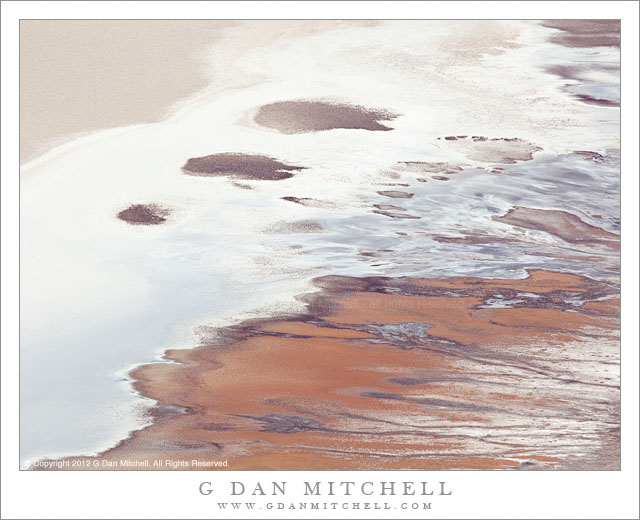
Salt Flat Patterns. Death Valley National Park, California. March 30, 2011. © Copyright 2012 G Dan Mitchell – all rights reserved.

Detail of a section of Death Valley salt flats as seen from Dantes View

Death Valley is often not quite what it seems to be. Repeat visits and views from different perspectives – far away, very close up, from above – begin to reveal things that you might not see at first. From next to and on the salt flats in the lowest section of the Valley, you see a very desolate terrain – one of the most non-human terrains I know. Here, well below sea level, there are places that seem completely inhospitable and alien, landscapes of caked salt, worked and sharp-edged salt and dried mud, seeps of shallow water, occasional odd plants, and landscape that often seems to go on almost endlessly the same way. But just as looking more closely reveals surprises (such as living creatures in those millimeters-deep pools of salty water), the view from overhead shows patterns that cannot be readily seen up close.

This photograph was made from the summit of Dantes View. This high point along the eastern side of the valley is close to a mile above the Valley floor. The view can often be panoramic, stretching for tremendous distances in almost all directions, blocked only by the higher peaks of the Panamint Range to the west and a few other high points nearby. Although Dantes View is one of the best known “iconic” locations in the park, I have a complicated relationship with the place. First of all, I seem to attract awful weather when I go there, perhaps because I tend to do so in the season that is winter elsewhere in the state. Not too long ago I attempted to drive to the summit on a winter day and was turned back by a snow storm perhaps a half mile from the end of the road. In addition, it has been hard for me to warm up to the place as a photographic subject. In some ways, there is almost just too much in the view for me to see how to isolate a photograph out of that detailed immensity. I dealt with that here by using a very long lens and restricting my view to a small section of the valley floor, without much context of surrounding terrain, which I think produces a photograph that allows the features in this frame to be seen as abstractions.

G Dan Mitchell is a California photographer and visual opportunist whose subjects include the Pacific coast, redwood forests, central California oak/grasslands, the Sierra Nevada, California deserts, urban landscapes, night photography, and more.
Blog | About | Flickr | Twitter | FacebookGoogle+ | 500px.com | LinkedIn | Email

Text, photographs, and other media are © Copyright G Dan Mitchell (or others when indicated) and are not in the public domain and may not be used on websites, blogs, or in other media without advance permission from G Dan Mitchell.