Tag Archives: burn

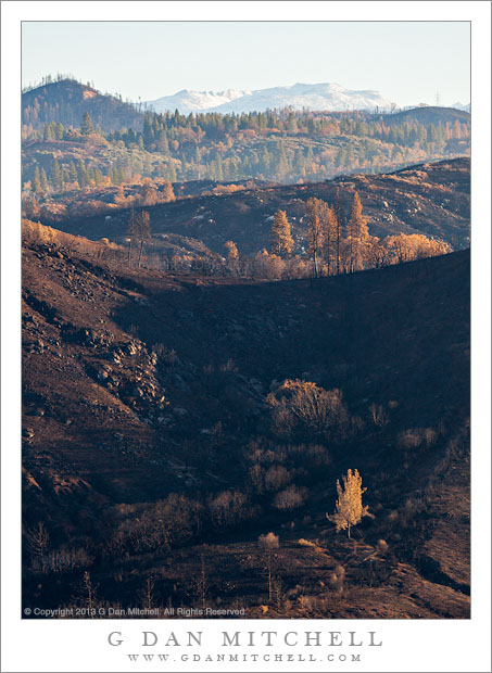
Rim Fire Burn Zone, Morning

Rim Fire Burn Zone, Morning

Rim Fire Burn Zone, Morning. Near Yosemite National Park, California. October 30, 2013. © Copyright 2013 G Dan Mitchell – all rights reserved.

An area near “Rim of the World” recently burned by the Rim Fire

Late this past summer one of the worst wildfires in the Sierra burned extensive areas near and within the northwest “corner” of Yosemite National Park. The “Rim Fire,” as it has come to be known (since it started near the “Rim of the World” overlook) came at a time of very bad conditions – in hot and dry weather, late in the season, and at the end of a second drought year in California. The first spread very quickly, and it took tremendous efforts to contain it – and full suppression took many, many weeks.

Since the fire burned in areas that I know very well from decades of travel through this part of the Sierra, I was anxious to see the extent of the damage. At first I thought I might get a chance in early September, when I traveled back and forth to the eastern Sierra to photograph fall colors. However, weather interfered – snow closed Tioga Pass Road and I ended up taking different routes across the range. Finally, at the very end of October, on a drive to Yosemite Valley I passed this way early in the morning. Overall, from what little I could observe, several things seem clear: the fire burned a very large area, some sections were very badly damaged and it will be a long time before trees grow there again, other sections were only lightly burned and a few were skipped over. This view, from the “Rim of the World” overlook, rises from the close charred hills above the Tuolumne River Canyon, across more distant ridges, and culminates at far peaks with a light dusting of early season snow. All of the conditions I described above are visible here – serious destruction in the foreground, a bit further in there are some trees that were burned by not killed, and far beyond there is forest that appears to have not been burned.

G Dan Mitchell is a California photographer and visual opportunist whose subjects include the Pacific coast, redwood forests, central California oak/grasslands, the Sierra Nevada, California deserts, urban landscapes, night photography, and more.
Blog | About | Flickr | Twitter | FacebookGoogle+ | 500px.com | LinkedIn | Email

Text, photographs, and other media are © Copyright G Dan Mitchell (or others when indicated) and are not in the public domain and may not be used on websites, blogs, or in other media without advance permission from G Dan Mitchell.

About the Yosemite “Rim” fire… and more

UPDATE and a NOTE:

Update: Shortly after I posted this, my reports on highway 120 through the park via the Tuolumne Meadows area  were rendered incorrect/outdated by way of an updated announcement from the park service as follows:

“Beginning at 12:00pm on Wednesday, August 28th, Tuolumne Meadows and the High Sierra will only be accessible via Highway 120 East through Lee Vining.  The Tioga Rd/Hwy 120 East will be temporarily closed between White Wolf Lodge and the Big Oak Flat Rd./Hwy 120 West at Crane Flat; the closure is estimated to be 3 to 4 days.  Tuolumne Meadows Lodge, the High Sierra Camps, and Tuolumne Meadows and Porcupine Flat campgrounds all remain open.”

Basically, this means that you will not be able to use highway 120 as a route across the Sierra until further notice. I’m not surprised – in fact, I’ve been somewhat surprised that the road remained open this long. Apparently the following URL is also a good source of updates from the park: http://www.yosemitepark.com/yosemite-fire-update.aspx

Note: All of which brings me back to my original statement that I don’t have inside information on this fire, and that anyone traveling to the area needs to check official sources for conditions updates. I will likely not update this page as things change, so the information posted here should be regarded as potentially being out of date!

My original post follows…

A few people have asked me for information about the “Rim” fire which started not far from Groveland near highway 120, and which is currently burning along the northwest boundary of Yosemite National Park, generally moving east and north toward the highway 108 area. While I know much of this area fairly well from many years (decades, actually) of visits, I do not have any inside information about the fire itself, nor am I an expert on wildfires. One good source of (limited but objective) information is the Stanislaus National Forest Rim Fire Incident web page. A map on this page is a quite amazing source of information, especially when combined with some familiarity with the area and a reading of various written reports. (The version on the main page seems to be based on Google Maps, and allows you to scroll around and zoom in.) Lots of folks who live and work in the area are sharing updates on the usual social media sites. The Mariposa Gazette is another local news source.

The fire started on August 17 more or less midway between Groveland and the  northwest park entrance and not far off of the highway 120 corridor near the Rim of the World area overlooking the canyon of the Tuolumne River. (Highway 120 is a common route for entry to the park from the west and northwest, and it connects via Tuolumne Meadows and Tioga Pass to the east side of the Sierra at the town of Lee Vining.) The spread of the fire at first was somewhat quick, which is no surprise given the extremely dry conditions in the Sierra following a second very dry winter and almost no real precipitation since late 2012. Then, between about August 20 and 23, the fire exploded, expanding  very quickly to cover a huge area generally to the east and north of the starting point, with the fire generally racing northeast but also spreading to the north and south. Continue reading About the Yosemite “Rim” fire… and more

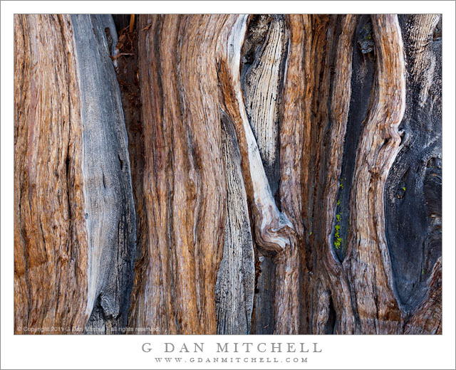
Juniper Tree Trunk, Detail

Juniper Tree Trunk, Detail

Juniper Tree Trunk, Detail. Yosemite National Park, California.August 12, 2011. © Copyright 2011 G Dan Mitchell – all rights reserved.

The heavily weathered and contorted trunk of juniper trees near Olmsted Point, Yosemite National Park.

These Sierra juniper trees grow in the most improbable places – on top of granite domes and slabs, with roots somehow finding sustenance in cracks and bits of gravel, and no doubt exposed to the full force of mountain storms. This is actually a group of trees that take advantage of the same crack in the otherwise solid granite, and which have grown together into what almost appears to be one very wide tree at first.

Because of their toughness, the way they grow almost into the rock, and the fact that the trees continue to live even when portions have died, it sometimes seems to me that these trees can have a character that is closer to that of the rock itself than just about any other living thing in the Sierra. The oldest branches and roots grow into the rock and have been shaped so much by their relationship to it that they can almost take on a rock-like character themselves.

These particular specimens happen to be growing part way up a dome-like granite slab above Tioga Pass Road as it passes through Yosemite’s high country. It appears that part of the treed may have been affected by fire, and dead sections have been worn and eroded by the tough sub-alpine environment. The only obvious signs of life in this close up image are the bits of moss or lichen growing in a few cracks in the wood.

G Dan Mitchell Photography
About | Flickr | Twitter | FacebookGoogle+ | 500px.com | LinkedIn | Email

Text, photographs, and other media are © Copyright G Dan Mitchell (or others when indicated) and are not in the public domain and may not be used on websites, blogs, or in other media without advance permission from G Dan Mitchell.
(Basic EXIF data may be available by “mousing over” large images in posts. Leave a comment if you want to know more.)

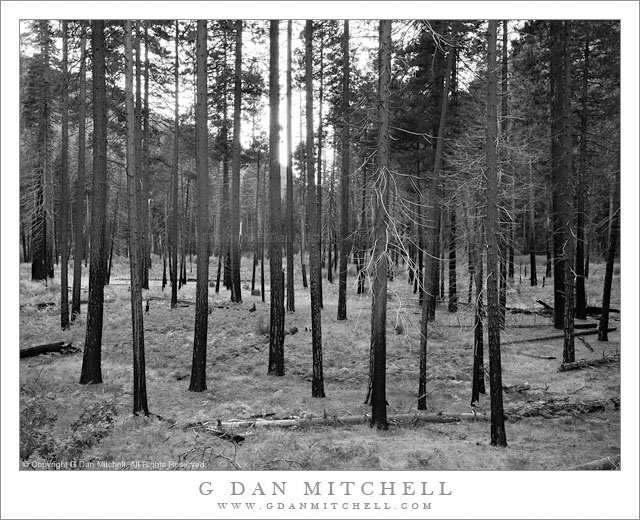
Burned Forest, Yosemite Valley, Autumn

Burned Forest, Yosemite Valley, Autumn

Burned Forest, Yosemite Valley, Autumn. Yosemite National Park, California. October 31, 2010. © Copyright G Dan Mitchell – all rights reserved.

Evening light in a burned section of the forest on the floor of Yosemite Valley.

I’ve been sitting on this photograph for a while, so I figure I’ll post it now. I made it last fall – on Halloween, actually! – during a fall color trip to the Valley. Late on my final evening I finally stopped and walked out across the old terminal moraine that crosses the lower Valley not far upstream from Pohono Bridge. (When you drive into the Valley, the road splits, and before long you’ll see the south end of this feature to your left as you go up a short climb.) I started at the north end and as I walked south looking for a photograph it was a very quite, still, and cold evening.

I finally found a spot where I could go down the lower side of the hill just a bit and find a relatively clear shot through the trees that wasn’t blocked by foliage closer to my position. This area has been burned, and I assume that it is the result of one of the management burns that often occur late in the season. These fires attempt to strengthen the forest by reintroducing the natural process and cycles of fire. The result is interesting charring patterns along the lower portions of the trees, temporary burned undergrowth, and then as the recovery takes place a much more open and airy sort of forest as you see in this photograph.

G Dan Mitchell Photography | Flickr | Twitter (follow me) | Facebook (“Like” my page) | LinkedIn | Email
Text, photographs, and other media are © Copyright G Dan Mitchell (or others when indicated) and are not in the public domain and may not be used on websites, blogs, or in other media without advance permission from G Dan Mitchell.