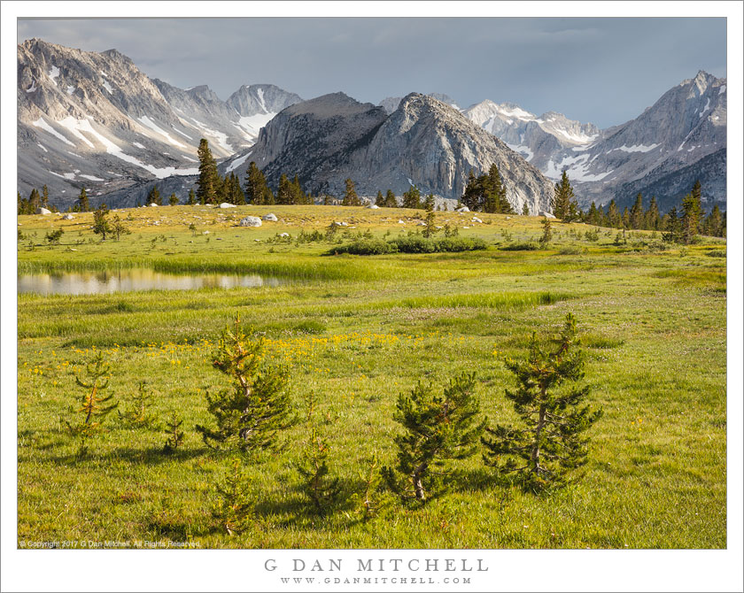
Tag Archives: capped

McGee Canyon and Mount Morgan

McGee Canyon and Mount Morgan

McGee Canyon and Mount Morgan. Owens Valley, California. October 10, 2010. © Copyright G Dan Mitchell – all rights reserved.

Snow crested Mount Morgan rises above McGee Canyon and the sagebrush-covered hills of Owens Valley in the eastern Sierra Nevada.

I’ve been traveling to the Sierra for many years. My first recollection of the range is a faint mental image of a shoreline park at Lake Tahoe when my family moved to California – I was four years old. My next memory is of staying at a small motel in El Portal next to the high water of the Merced River back in the days before the current mega-hotels were erected. One thing that all of my early Sierra experiences had in common is that I always approached the range from the west since I lived (and still live) in the San Francisco Bay Area. For the person whose orientation to the range is from the west, the Sierras are a range that begins almost imperceptibly in the Central Valley. Although you can see distant peaks from the Valley on clear days, it is hard to say where the range begins. As you head east you encounter some very small and rounded hills which gradually get larger. Eventually you are going up more than up and down as you  travel through oak and grass lands. At some point the road rises into forest, but the mountain tops are mostly rounded and forest covered. Keep going and a few rocky prominences begin to appear along the ridges and some distant granite peaks become visible. Only after a lot of driving do you find yourself in the higher reaches of the range, and this only in the few areas where roads cross from west to east. In most places you cannot even see the summit of the range close up from the west without walking a long ways.

It was only many years later that I first went over the summit of the range and saw it from the east side. The Sierra is (are?) completely different when approached this way. Instead of a long, gradual, and relatively gentle rise to high valleys and forests and meadows, the eastern escarpment of the Sierra rises abruptly – one might say violently – and directly, in most places, from the high desert sagebrush country of Owens Valley and similar places. This wall of peaks seems almost inaccessible, and I imagine that many people who only drive past on highway 395 must regard it that way.

This photograph was made from a spot just a mile or two east of highway 395, out an a gravel road that I know. I have photographed this shadowed foreground ridge and the peaks beyond in the past, so I had a fairly good idea of what I would find at this location before I made the photograph on an early October morning when fall storms had dusted the highest peaks with snow. I used a somewhat long lens and tight framing to emphasize the rise from the foreground desert to the very high peaks beyond.

This photograph is not in the public domain and may not be used on websites, blogs, or in other media without advance permission from G Dan Mitchell.

G Dan Mitchell Photography
Flickr | Twitter | Facebook Fan Page | Facebook | Friendfeed | Email

Mount Morrison and Desert Hills, Morning

Mount Morrison and Desert Hills, Morning

Mount Morrison and Desert Hills, Morning. Owens Valley, California. October 10, 2010. © Copyright G Dan Mitchell – all rights reserved.

Early morning light on sagebrush covered Owens Valley hills and the Sierra crest near Mount Morrison.

I was out in this section of Owens Valley early on this October morning, initially to photograph at a small lake further out in the valley. However, knowing parts of this area pretty well from past visits, I wanted to try a photograph that included the foreground tree-covered ridge in morning light with the Sierra peaks in the background – so I headed back on a gravel road that travels a bit north of the paved road I had taken earlier in the morning. I found this scene with the early light illuminating the crest of the Sierra and the sagebrush-covered foreground hills, but with morning shadows still lying across the lower eastern face of the Sierra just south of Convict Lake.

The dusting of early season snow was left over from a week of early autumn storms. Mt. Morrison is the huge and impressive summit at the right end of the ridge. Mt. Baldwin is the small but very high summit near the left end. In between is a vertical rock face that appears to be split by a crack – I think it is called “the Great White Fang.”

This photograph is not in the public domain and may not be used on websites, blogs, or in other media without advance permission from G Dan Mitchell.

G Dan Mitchell Photography
Flickr | Twitter | Facebook Fan Page | Facebook | Friendfeed | Email

Morning Fog on Hot Creek, Mount Morrison

Morning Fog on Hot Creek, Mount Morrison

Morning Fog on Hot Creek, Mount Morrison. Owens Valley, California. October 9, 2010. © Copyright G Dan Mitchell – all rights reserved.

Morning fog rises above Hot Creek with the Sierra crest and Mount Morrison in the distance.

Finding this shot was just about as random a process as I can imagine. I was in the eastern Sierra to photograph aspens, and staying in Mammoth Lakes. I woke up very early without a really solid idea of where I’d shoot that morning, but started out heading for Rock Creek, where I had seen great aspen color a week earlier. As I left Mammoth and headed south on highway 395 I noticed low fog out in Owens Valley – Crowley Lake was pretty much covered and it appeared that there were bits of fog here and there above creeks and springs in the valley. This started to look more interesting to me than photographing aspens again, so I changed plans and headed out into Owens Valley, not knowing precisely where or what I might find but thinking it would involve fog and mist and early morning light.

I first stopped and photographed near a small pond along side the road. After shooting here a bit – mostly shots pointing back toward the Sierra crest – I recalled that I had been on some gravel roads a bit further north of my position, and I decided to do a bit of exploring. I turned off on the first road going north and followed it until I found another interesting road that dropped down into a small valley and crossed a creek on an old rickety bridge – I later figured out that this was Hot Creek. A cloud of mist and fog was lying above the path of the creek, periodically thickening and thinning, and because it was not deep the morning sun was still somewhat lighting the scene through the fog. At times the peaks of the Sierra crest would gradually resolve through the fog. I set up and waited and made some exposures as the fog rose and fell, increased and decreased.

This photograph is not in the public domain and may not be used on websites, blogs, or in other media without advance permission from G Dan Mitchell.

G Dan Mitchell Photography | Twitter | Friendfeed | Facebook | Facebook Fan Page | Email

Mount Morgan and Slopes of McGee Mountain, Morning

Mount Morgan and Slopes of McGee Mountain, Morning

Mount Morgan and Slopes of McGee Mountain, Morning. Owens Valley, California. October 10, 2010. © Copyright G Dan Mitchell – all rights reserved.

Morning light on the lower slopes of McGee Mountain, the McGee Creek Canyon area and snow-capped Mount Morgan, with Owens Valley sagebrush and hills in the foreground.

I began my early morning shoot in Owens Valley near a small lake further to the east where I wanted to photograph dawn light. I had a plan to shoot a few other subjects in the valley and back toward the Sierra crest as the sun rose and the light changed, and part of this plan included driving along a gravel road I know to a spot where I had photographed before to try to combine the high desert sagebrush and rolling hills with some of the tall and rugged, snow-topped peaks along the escarpment of the eastern Sierra. I found a spot in the general area of where I wanted to photograph and then wandered off down a small dirt track to find a location that would put the foreground shadow across the lower part of the frame.

The area of the Sierra in this photograph includes the sunlit lower slopes of McGee Mountain on the right, McGee Creek Canyon beyond that, and ridges leading to the snow-capped summit of Mount Morgan. I’m not certain whether they are visible in this photograph, but beyond that lies Pioneer Basin (on the other side of the crest) and a group of four peaks named for the “Railroad Barons” of the 1800s: Crocker, Stanford, Huntington, and Hopkins.

This photograph is not in the public domain and may not be used on websites, blogs, or in other media without advance permission from G Dan Mitchell.

G Dan Mitchell Photography | Twitter | Friendfeed | Facebook | Facebook Fan Page | Email

keywords: owens, valley, sage, sagebrush, hills, high, desert, mount, morgan, snow, capped, peak, ridg