Tag Archives: fold

Utah Backroad

Utah Backroad
“Utah Backroad” — A Utah backroad ascends into a steep canyon at Capitol Reef National Park.

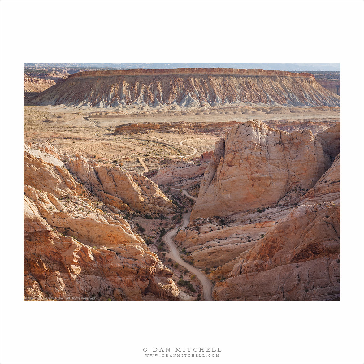
This track turns off from another gravel backcountry road and then winds its way into the high sandstone mountains of Capitol Reef National Park. There are roads like this all over Utah, and they lead to some incredible country. This one is in a national park, but many are not — yet they traverse country that would be worthy of such a designation. Fortunately the rough (sometimes very rough) routes minimize tourist impact.

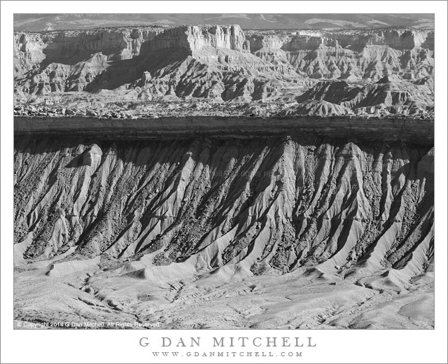
This one rises in a huge Utah feature called the Waterpocket Fold, a long line of rising strata that form a valley and adjacent mountains. The scene has most of the typical Utah backcountry features — a large butte, dry flatland, sandstone towers, and even some nearby canyons.


Leave a comment or question using the form. (If you are reading this on the home page, click the article title to see the full article and the comment form.

G Dan Mitchell is a California photographer and visual opportunist. His book, “California’s Fall Color: A Photographer’s Guide to Autumn in the Sierra” (Heyday Books) is available directly from him. Blog | Bluesky | Mastodon | Substack Notes | Flickr | Email

All media © Copyright G Dan Mitchell and others.

Sand Patterns

Sand Patterns
Varied sand patteres on a fold in dunes at Death Valley National Park.

Sand Patterns. © Copyright 2022 G Dan Mitchell.

Varied sand patterns on a fold in dunes at Death Valley National Park.

One of the myths about sand dunes is that their features are in motion, being blown across the landscape by winds. The fact that so many features — ripples, waves — remind us of water reinforces the illusion. But here the fluidity is of a largely static sort, and these features tend to remain in much the same place over long periods of time.

The reasons that dunes come into existence begin to be obvious when ou get to know them. They tend to be in windy places where natural features obstruct, divert, and slow the winds, causing them to drop their load of airborne dust and sand. While these broad features are easy to understand, I remain mystified by the smaller scale features like those seen in this “intimate landscape” photograph — the waves, ridges, valleys, drop-offs that also tend to remain fixed.


G Dan Mitchell is a California photographer and visual opportunist. His book, “California’s Fall Color: A Photographer’s Guide to Autumn in the Sierra” is available from Heyday Books, Amazon, and directly from G Dan Mitchell.

Blog | About | Flickr | FacebookEmail

Links to Articles, Sales and Licensing, my Sierra Nevada Fall Color book, Contact Information.

Scroll down to leave a comment or question. (Click this post’s title first if you are viewing on the home page.)


All media © Copyright G Dan Mitchell and others as indicated. Any use requires advance permission from G Dan Mitchell.

Strata and Folds, Evening

Strata and Folds, Evening
Desert terrain of contorted and folded strata

Strata and Folds, Evening. Death Valley National Park, California. March 30, 2015. © Copyright 2015 G Dan Mitchell – all rights reserved.

Desert terrain of contorted and folded strata

It has been well over a year since I made this photograph, but I remember the evening well. I had arrived in Death Valley earlier in the day, by way of a detour through the Los Angeles area, found a place to camp, and was now starting several days of intensive photography in the area. In the evening I headed south in the park to a particular knoll that I have photographed from before, with the idea of photographing a particular subject in some light that I had in mind.

I found and photographed that subject, though conditions weren’t quite what I expected. A combination of evening haze and strong winds presented some challenges — and I’ll need to return to the spot to make that photograph that I originally envisioned. However, from this elevated position there was a spectacular view of arid and rugged desert terrain in the opposite direction, so as the light on my original subject faded I turned my attention in this direction. There are many things to think about and say about terrain like this, but I’ll mention one thing. When we look at such a place our first impression is of the rugged dryness. But when we look again we see evidence of water everywhere in such a landscape — in those valleys, and in the gullies tracing twisting lines down the faces of the formations.


G Dan Mitchell is a California photographer and visual opportunist. His book, “California’s Fall Color: A Photographer’s Guide to Autumn in the Sierra” is available from Heyday Books and Amazon.
Blog | About | Flickr | Twitter | FacebookGoogle+ | LinkedIn | Email


All media © Copyright G Dan Mitchell and others as indicated. Any use requires advance permission from G Dan Mitchell.

Waterpocket Fold Terrain

Waterpocket Fold Terrain
Deep erosion gullies below an uplifted rock band empty into the valley below, with rugged terrain extending into the distance

Waterpocket Fold Terrain. Capitol Reef National Park, Utah. October 22, 2014. © Copyright 2014 G Dan Mitchell – all rights reserved.

Deep erosion gullies below an uplifted rock band empty into the valley below, with rugged terrain extending into the distance

Until a few years ago, although I had heard the term “waterpocket fold” before, I was almost completely unaware of what this geological feature is. Since that time I have visited it several times. On the first occasion I visited the area, but I still did not understand the geology. I “got it” that there was some sort of uplift — the land rising to the west of Capitol Reef was a pretty good clue — but I did not understand or really see any of the connections. I recall stopping at one road side pullout and seeing a sign about it, registering that it is something important, but not really understanding.

On more recent visits the reality of this huge and striking feature has finally sunk in. I began to see it a few years ago on a trip that took we away from main roads and way up on a rocky ridge from which I could look down into the eastern valley and clearly see some of the larger patterns — sinuous lines of angled rock, the valley twisting gently into the distance in the south. On the most recent visit it began to make a lot more sense, as I noticed features like the shadowed cliff band across the center of this photograph, which more or less represents the remaining underside of a layer that long ago continued on up into what today would be the sky. Its edge overhangs the softer material below, though it still erodes into the bottom of the valley. Further to the east in this photograph the impossibly rugged terrain of arid strata continues, eventually rising to a mountain range in the far distance.


G Dan Mitchell is a California photographer and visual opportunist. Blog | About | Flickr | Twitter | FacebookGoogle+ | 500px.com | LinkedIn | Email


All media © Copyright G Dan Mitchell and others as indicated. Any use requires advance permission from G Dan Mitchell.