Tag Archives: highway

Panamint Valley, Wash

Panamint Valley, Wash
A large desert wash curves towards the Panamint Valley

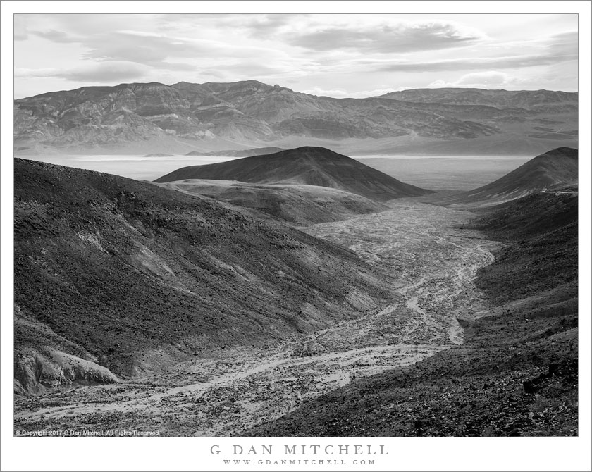
Panamint Valley, Wash. Death Valley National Park, California. April 7, 2017. © Copyright 2017 G Dan Mitchell – all rights reserved.

A large desert wash curves towards the Panamint Valley

I always associate this view, of this canyon and the valley and mountains beyond, with leaving Death Valley. For many years I always access the park via the road up from Ridgecrest that passes through the desolate town of Trona, coming up the Panamint Valley before entering the park, either over Towne Pass or via Emigrant Pass and Wildrose Canyon. At some point I decided to take what I later determined to be the route favored by many other visitors, route 190 across to highway 395 at Olancha near the dry desolation of Owens Lake.

This view lies along that route. Shortly after leaving Panamint Valley the road passes up a bit of a canyon, crosses a ridge, and then tracks along the slopes paralleling this wash that runs out into Panamint Valley. The wash itself has a beautiful quality, curving gracefully around toward its arrival in the larger valley between the two dark, rounded hills. Across the Panamint Valley, at the base of the far mountains, there are sandy stretches which develop into full-blown dunes just a bit to the left of the area shown in the photograph. On this morning a weather from was coming in, producing some dramatic clouds above the Panamint Range.


G Dan Mitchell is a California photographer and visual opportunist. His book, “California’s Fall Color: A Photographer’s Guide to Autumn in the Sierra” is available from Heyday Books and Amazon.
Blog | About | Flickr | Twitter | FacebookGoogle+ | LinkedIn | Email


All media © Copyright G Dan Mitchell and others as indicated. Any use requires advance permission from G Dan Mitchell.

Big Sur, Winter

Big Sur, Winter
Sediment from flowing streams and landslides colors the water along the Big Sur Coast near Julia Pfeiffer Burns State Park

Big Sur, Winter. Big Sur Coast, California. January 5, 2017. © Copyright 2017 G Dan Mitchell – all rights reserved.

Sediment from flowing streams and landslides colors the water along the Big Sur Coast near Julia Pfeiffer Burns State Park

Some viewers who know this coast very, very well might understand why this photograph could have been titled, “Not McWay Fall.” In an example of looking the “wrong” direction, this photograph looks north along the Big Sur coast in the afternoon, when the light comes in from the west and perhaps begins to warm a bit, and on a beautiful winter day, on the heels of a big storm, when the air is very, very clear and the water is intensely blue.

Looking closely you probably also notice some other colors in the water. Various things can color the coastal waters — seasonal or time of day variations, the quality of the light, reflections, algae, and much more. There are a few spots along this coast where the water is always a surprising color, for example where sandy shoals in shallow, protected water lighten it. Several things were at work here on this day. Coastal creeks were in full flow, carrying their sediment loads down to the coast and emptying into the ocean. In this particular location there was a very large and probably still active landslide that had delivered a lot of earth to the beach, where the surf was gradually pulling it into the water and staining the ocean brown.


G Dan Mitchell is a California photographer and visual opportunist. His book, “California’s Fall Color: A Photographer’s Guide to Autumn in the Sierra” is available from Heyday Books and Amazon.
Blog | About | Flickr | Twitter | FacebookGoogle+ | LinkedIn | Email


All media © Copyright G Dan Mitchell and others as indicated. Any use requires advance permission from G Dan Mitchell.

Elephant Seals, Stream

Elephant Seals, Stream
Elephant seals cavort in a fresh water stream flowing across a beach

Elephant Seals, Stream. California Coast. January 5, 2017. © Copyright 2017 G Dan Mitchell – all rights reserved.

Elephant seals cavort in a fresh water stream flowing across a beach

During the first week of the new year we travelled to Southern California for a family event. These days we are more likely to take the plane or train for such things, but since our oldest son and his wife were visiting from New York and also were headed that direction we decided to drive and take the Pacific Coast Highway — not fast but certainly scenic. That plan also fell through. We didn’t check road conditions before departing and right around Carmel we saw a sign announcing that the route was closed some miles to the south. Normally that would mean turning around, but since one in our group had never seen the area at all we decided to at least go to Big Sur for lunch before turning around and using highway 101 instead. After lunch I happened to check my phone, and I discovered that the route had been cleared literally minutes earlier — and the Big Sur Coast drive was back on!

Below the most rugged section of the route (roughly south of Ragged Point) the terrain flattens out and becomes much more gentle. In this area there is a well-known elephant seal rookery, where these huge animals haul out and give birth each year. The elephant seal population was once endangered, but protections have brought them back and they are now becoming much more common along California’s coast. These animals had split off from the larger group to enter the fresh water of a coastal stream where it crossed the beach to join the ocean, with the water backlit by the late afternoon sun.


G Dan Mitchell is a California photographer and visual opportunist. His book, “California’s Fall Color: A Photographer’s Guide to Autumn in the Sierra” is available from Heyday Books and Amazon.
Blog | About | Flickr | Twitter | FacebookGoogle+ | LinkedIn | Email


All media © Copyright G Dan Mitchell and others as indicated. Any use requires advance permission from G Dan Mitchell.

Clearing Storm, Pacific Coast

Clearing Storm, Pacific Coast
An autumn storm clears along the Northern California cost above Fort Bragg

Clearing Storm, Pacific Coast. North of Fort Bragg, California. November 19, 2016. © Copyright 2016 G Dan Mitchell – all rights reserved.

An autumn storm clears along the Northern California cost above Fort Bragg

On this November day, the light along the Pacific coast north of Fort Bragg, California was mostly spectacular and in a constant state of change. In rained, occasionally hard and more than once taking us by surprise, there was fog, the sun appeared, clouds were dark one moment and luminously bright the next.

We paused at this overlook, where the meeting of land and water is less steep. The nearly level coastal bluffs run along the water at the base of low coastal mountains, and the underwater slope is also apparently not very steep, judging from the distance from the shoreline that the waves begin to rise and break. The atmosphere was semi-opaque, filled with a combination of fog and light rain, and the glow of light on clouds was diffused and soft. To the west, sun broke through the clouds and lit the water brilliantly in patterns that curved toward the horizon. The waves broke against the seaward side of the huge sea stack — more of an island, really — that stood in front of us just off from the shoreline.


G Dan Mitchell is a California photographer and visual opportunist. His book, “California’s Fall Color: A Photographer’s Guide to Autumn in the Sierra” is available from Heyday Books and Amazon.
Blog | About | Flickr | Twitter | FacebookGoogle+ | LinkedIn | Email


All media © Copyright G Dan Mitchell and others as indicated. Any use requires advance permission from G Dan Mitchell.