
Tag Archives: Mountain

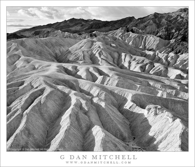
Eroded Gullies at Zabriskie Point, Morning

Eroded Gullies at Zabriskie Point, Morning

Eroded Gullies at Zabriskie Point, Morning. Death Valley National Park, California. April 6, 2006. © Copyright 2011 G Dan Mitchell – all rights reserved.

Low angle morning light illuminates a tortured landscape of eroded gullies at Zabriskie Point, Death Valley National Park.

I recently “rediscovered” this photograph while undertaking a major review of the past eight years of my raw files. (And, yes, that task is just about as much fun as you might imagine. It would actually be pretty unbearable except that every so often I find some photographs that I had perhaps forgotten or overlooked, and I also come across images that remind me of experiences that took place some time ago.)

This photograph was made, as virtually anyone who has visited the spot recognizes, by pointing my camera about 90 degrees to the left of the classic Zabriskie Point views. Timing was important, as the early light is just skimming across the tops of these tortuously eroded gullies, picking out the ridges between them but leaving the lower sections in shadow. But good fortune also played a role here. Death Valley is usually a clear blue sky kind of place, but on this morning I had clouds! At dawn, if I recall correctly, the clouds actually interfered with the light a bit. But as the sun rose the clouds provided a more dramatic background than plain blue sky and created some softer and diffused light that gave just the right sort of dynamic range for photographs.

On a technical note, if you are viewing this in the right web browser you can mouse over the image and see a summary of basic EXIF data. (Sorry, but this feature only works in web browsers – if you are viewing email, etc. you’ll need to visit the version at my blog to see the EXIF.) If you do check the EXIF you might notice that this photograph was made with a very humble example of photographic technology, the Canon Digital Rebel XT. This camera is a 8MP cropped sensor “consumer” camera that I acquired when I first tested the waters of DSLR photography. (I had actually used digital cameras back in the 1990s, but not for serious photographic work.) Those who wonder which of today’s current DSLRs might enable them to produce interesting and effective images might consider what could be done with such a humble camera. ;-)

G Dan Mitchell Photography
About | Flickr | Twitter | Facebook | Google+ | 500px.com | LinkedIn | Email

Text, photographs, and other media are © Copyright G Dan Mitchell (or others when indicated) and are not in the public domain and may not be used on websites, blogs, or in other media without advance permission from G Dan Mitchell.

(Basic EXIF data may be available by “mousing over” large images in posts. Leave a comment if you want to know more.)
Owens Valley Sky

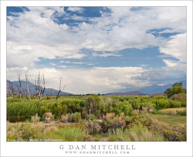
Owens Valley Sky
Owens Valley Sky

Owens Valley Sky. Owens Valley, California. August 6, 2005. © Copyright 2011 G Dan Mitchell – all rights reserved.

Dramatic thunderstorms begin to build above Owens Valley, flanked by the White Mountains and the eastern Sierra Nevada range.

If there is any good news about starting to run out of space on my hard drive, it might be that it encourages me to begin the process of reviewing my tens of thousands of archived raw image files, and that leads me to look through files that I haven’t revisited in a long time – and during this process I find photographs that I had forgotten about. Not only is it worthwhile to rediscover these photographs that ended up buried in the archive, but it is also a chance to recall some of the trips on which the photographs were made.

This photograph is yet another (of many!) that wouldn’t have happened at all if it were not for a whole unpredictable series of events and circumstances. I’ll make the story as short as I can, but it is still a bit involved. Almost every summer I share a long pack trip with a group of my friends. In 2005 we had come up with a 14-day trip along a good portion of the John Muir Trail between roughly the Ediza Lake area and Bishop Pass, which included one of the very few sections of the JMT that I had not hiked. We started at Agnew Meadow, headed up past Shadow Lake, turned south on the JMT, stopped at Reds Meadow, continued on to the Duck and Purple Lakes area… where I started to feel like I might be coming down with some sort of bug. Discretion being the better part of valor and all that, I decided that the prudent thing was to bail out of the trip and exit to Mammoth Lakes since the idea of getting sick on the fourth day of a 14-day hike with a large group was not appealing.

So I hiked out. Ironically, once I crossed the pass to head down to the Mammoth area, I recovered – but it was now too late to rejoin my group since they would be two days ahead of me on the trail at this point. Since I was back at my car now and feeling just fine I figured that I might as well do something else before heading home, so I decided to drive up into the White Mountains and visit the Bristlecone Pine forest. On the way back down from the Whites I just happened to pull out at this spot where the high desert terrain was extra green around a creek, on an afternoon when monsoon conditions were leading to a buildup of afternoon clouds above the Sierra, the Whites, and Owens Valley between the two ranges.

G Dan Mitchell Photography
About | Flickr | Twitter | Facebook | Google+ | 500px.com | LinkedIn | Email

Text, photographs, and other media are © Copyright G Dan Mitchell (or others when indicated) and are not in the public domain and may not be used on websites, blogs, or in other media without advance permission from G Dan Mitchell.

(Basic EXIF data may be available by “mousing over” large images in posts. Leave a comment if you want to know more.)

Boulders, Shoreline Reflections

Boulders, Shoreline Reflections

Boulders, Shoreline Reflections. Yosemite National Park, California. July 29, 2011. © Copyright 2011 G Dan Mitchell – all rights reserved.

Granite boulders lie in shallow waters of a sub-alpine lake reflecting shoreline trees, Yosemite National Park.

This quiet little lake lies unobtrusively just off of highway 120 across the Sierra Nevada in Yosemite National Park. I’ve posted a few photographs from here before and noted that, as far as I know, the lake doesn’t even have an official name. There is just a small parking loop where you can pull out and then wander down to the lake, typically in complete solitude.

The light is a bit tricky here since the lake is in a depression where ridges to the east block the morning light. However, the wonderful rocks scattered along the shoreline make up for this! I made this photograph, and several others in the sequence, by shooting with a long lens from the other side of the lake. The low camera angle and still water created some very interesting reflections above the barely visible underwater logs and rocks.

G Dan Mitchell Photography
About | Flickr | Twitter | Facebook | Google+ | 500px.com | LinkedIn | Email

Text, photographs, and other media are © Copyright G Dan Mitchell (or others when indicated) and are not in the public domain and may not be used on websites, blogs, or in other media without advance permission from G Dan Mitchell.

(Basic EXIF data may be available by “mousing over” large images in posts. Leave a comment if you want to know more.)

Pond with Boulders and Trees

Pond with Boulders and Trees

Pond with Boulders and Trees. Yosemite National Park, California. July 28, 2011. © Copyright 2011 G Dan Mitchell – all rights reserved.

A small pond reflects trees and glaciated boulders, Yosemite National Park.

This is a little location that I’ve returned to since I first discovered it a few years ago when I made a random stop along Tioga Pass Road to photograph some fog, looked away from the road, and saw a faint trail leading off into a little valley that looked to be full of rocks. Later I returned and wandered out on the trail and discovered a surprising landscape with glaciated granite, small pools, open forest, and small meadows. The first time I photographed there I had little time, so it ended up being more of a scouting visit than a shoot. However, this summer I planned to reserve part of a morning to wander back up this trail during the time when the light would still be good.

The pools here are almost completely still. The water is flowing, but not much, especially in the small granite rimmed pools like this one. The light was just barely beginning to filter down through the trees, so I had to be a bit careful to avoid hot spots where the sun shone. I’d share where this spot is, except that if you think about what you are passing as you drive along Tioga Pass Road, and occasionally stop and look around, you can probably find your own little spots like this one.

G Dan Mitchell Photography
About | Flickr | Twitter | Facebook | Google+ | 500px.com | LinkedIn | Email

Text, photographs, and other media are © Copyright G Dan Mitchell (or others when indicated) and are not in the public domain and may not be used on websites, blogs, or in other media without advance permission from G Dan Mitchell.

(Basic EXIF data may be available by “mousing over” large images in posts. Leave a comment if you want to know more.)