Tag Archives: overlook

Sunset, Chessman Point, Cedar Breaks

Sunset, Chessman Point, Cedar Breaks
S”Sunset, Chessman Point, Cedar Breaks” — unset light at Chessman Point, Cedar Breaks National Monument

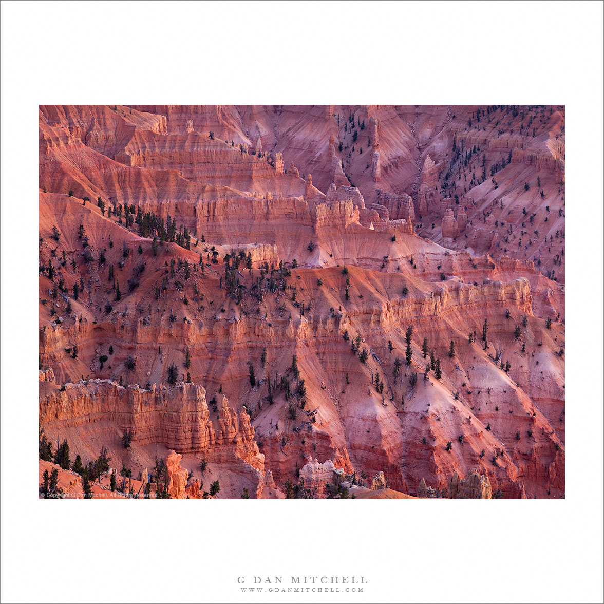
This was my first visit to Cedar Breaks National Monument in Utah. On my previous trip though Utah we had driven past the roads leading to Cedar Breaks and – doing what one does while driving these days! – we looked it up on the iPhone, and it sounded quite interesting. The descriptions suggested a high elevation bowl with Bryce Canyon-like features that would be open to the west and sunset light. With this in mind, we decided to end our cross-Nevada drive with an overnight at Brian Head, the seasonally dormant ski area where rooms were both relatively inexpensive and quite nice! After checking in we drove on up the road to the National Monument.

The terrain is very interesting and very “not California” to this Sierra Nevada guy. On one side of the ridge is a gently rolling high terrain of alternative forest and meadows, just the sort of place to find lots of deer in the evening and an altogether quiet and peaceful sort of place. On the other side of the ridge, however, things are quite different. The mountain simply drops away to the west, with brightly colored and complex fluted canyons of red rock and soil. Far below and in the distance we could see large groves of aspen trees. A strong wind was blowing up the west-side canyons, but I managed to stabilize things enough to make a few photographs of this spectacular terrain in near-dusk light.


Leave a comment or question using the form. (If you are reading this on the home page, click the article title to see the full article and the comment form.

G Dan Mitchell is a California photographer and visual opportunist. His book, “California’s Fall Color: A Photographer’s Guide to Autumn in the Sierra” (Heyday Books) is available directly from him. Blog | Bluesky | Mastodon | Substack Notes | Flickr | Email

All media © Copyright G Dan Mitchell and others.

Murphy Point, Sunset

Murphy Point, Sunset - Sunset light on Murphy Point, photographed from Green River Overlook, Canyonlands National Park
Sunset light on Murphy Point, photographed from Green River Overlook, Canyonlands National Park

Murphy Point, Sunset. Canyonlands National Park, Utah. April 6, 2012. © Copyright 2012 G Dan Mitchell – all rights reserved.

Sunset light on Murphy Point, photographed from Green River Overlook, Canyonlands National Park.

We spent the better part of a day scouting around the “Island in the Sky” section of Canyonlands National Park, partly with the goal of figuring out where to be for golden hour light. In the end, the very first place we had really considered ended up being the place we came back to – the Green River Overlook. While quite a few landscape photographs can be somewhat spontaneous and a matter of quickly taking advantage of ephemeral conditions, the decision to photograph at the Green River Overlook was quite the opposite. Not only had I decided that I wanted to shoot at this location, but I had even worked out the composition of the shot that I wanted.

With that in mind, we came back here almost an hour before actual sunset, confident that the photograph I had in mind would be waiting for me. And it was! That photograph was shot looking roughly west or a bit south of west and across the canyons dropping into the Green River. But I also had quite a bit of time to look around at other possible subjects as the light slowly transformed. The steep upper cliffs of (what I believe to be) Murphy Point stood to my south and the sunset light began to intensely color their red rocks during the final few minute of sunlight. So I took a moment away from the shot I had come for, pivoted the tripod this direction, and made a few exposures. The geology seen in this area is amazing. Layer upon layer build from the bottoms of the river canyon, through the side canyons and onto the lower plateaus. Then shattered rock stacks up against the tall upper sandstone cliffs that are topped by the relative flatlands of the “Island in the Sky” area. Here the low angle side-light from the setting sun reveals a lot of the more subtle details of this landscape.

G Dan Mitchell is a California photographer whose subjects include the Pacific coast, redwood forests, central California oak/grasslands, the Sierra Nevada, California deserts, urban landscapes, night photography, and more.
Blog | About | Flickr | Twitter | FacebookGoogle+ | 500px.com | LinkedIn | Email

Text, photographs, and other media are © Copyright G Dan Mitchell (or others when indicated) and are not in the public domain and may not be used on websites, blogs, or in other media without advance permission from G Dan Mitchell.

Cliff, Green River Overlook

Cliff, Green River Overlook - The canyon of the Green River beyond a band of sandstone cliffs, Canyonlands National Park, Utah
The canyon of the Green River beyond a band of sandstone cliffs, Canyonlands National Park, Utah

Cliff, Green River Overlook. Canyonlands National Park, Utah. April 6, 2012. © Copyright 2012 G Dan Mitchell – all rights reserved.

The canyon of the Green River beyond a band of sandstone cliffs, Canyonlands National Park, Utah.

I was in this spot primarily to photograph the late afternoon and evening light on the canyons, cliffs, plateaus, and mesas around the Green River. (I’ve recently posted a couple of other photographs of that subject.) One of the many striking aspects of the geology in this park is the sudden cliffs that drop from the edges of large flat areas. The upper portion of Canyonlands park, called the “Island in the Sky” is such a place. It is a large and relatively flat plateau, and if you disregard the more distant surroundings it seems like a prairie or perhaps a high desert grassland. But when you venture to its edges you most often find, on at least three of its sides, that there is a sudden drop off where the river systems below have eroded the surrounding terrain up to the edges of giant sandstone strata. I’m not an expert on the area, but one thing I read pointed out, if I recall correctly, that there is an upper plateau (the island in the sky), a 1000 foot drop, another plateau marked by the White Rim, and then another sudden drop into the depths of the surrounding river canyons.

So this bit of vertical sandstone is the upper portion of part of that first 1000-foot drop-off, in this case with the White Rim plateau and then some additional canyons beyond. Shooting late in the day, I was pointing the camera almost straight into the light – something that I often like to do. This allowed me to capture the faint shadow in the atmospheric haze formed as the light passed between two buttes at the upper edge of the frame. It also created a bit of a challenge in retaining detail in the fully shaded dark-colored cliff face! I was able to capture this in a single exposure that tested the dynamic range of my camera, and then bring back a bit of the cliff detail in post. Now, if I had just had someone stand, or better yet, dance on that cliff edge… Any volunteers for my next visit? ;-)

G Dan Mitchell is a California photographer whose subjects include the Pacific coast, redwood forests, central California oak/grasslands, the Sierra Nevada, California deserts, urban landscapes, night photography, and more.
Blog | About | Flickr | Twitter | FacebookGoogle+ | 500px.com | LinkedIn | Email

Text, photographs, and other media are © Copyright G Dan Mitchell (or others when indicated) and are not in the public domain and may not be used on websites, blogs, or in other media without advance permission from G Dan Mitchell.

Turks Head, Green River

Turks Head, Green River - The green river curves around Turks Head and through deep canyons in hazy evening light, Canyonlands National Park, Utah
The green river curves around Turks Head and through deep canyons in hazy evening light, Canyonlands National Park, Utah

Turks Head, Green River. Canyonlands National Park, Utah. © Copyright 2012 G Dan Mitchell – all rights reserved.

The green river curves around Turks Head and through deep canyons in hazy evening light, Canyonlands National Park, Utah.

I made several photographs Canyonlands National Park’s Green River Overlook on this beautiful early April evening. The upper portion of this area of the park is a high, flat area at about 6000′ of elevation that tends to drop off steeply, especially on the east, south, and west sides which lead to the canyons of the Colorado and Green Rivers just above their confluence. Below this upper plateau there is a second plateau at the level of the White Rim about 1000′ lower, with yet another drop-off into the bottoms of the river canyons and their tributaries.

This photograph is looking roughly southwest into the canyon of the Green River, which is barely visible between the foreground White Rim area and the solitary butte of “Turks Head” just beyond. (At least I hope it is Turks Head! That looks to be the only feature in this area that would fit that description, but I’m now to this geography.) At this early evening time the light was slanting nearly horizontally across the scene from the right and hitting a few of the west-facing slopes and glancing along the top of the White Rim. Haze filled the air, softening the light, muting the colors of the scene, and accentuating the grand scale of this landscape.

G Dan Mitchell is a California photographer whose subjects include the Pacific coast, redwood forests, central California oak/grasslands, the Sierra Nevada, California deserts, urban landscapes, night photography, and more.
Blog | About | Flickr | Twitter | FacebookGoogle+ | 500px.com | LinkedIn | Email

Text, photographs, and other media are © Copyright G Dan Mitchell (or others when indicated) and are not in the public domain and may not be used on websites, blogs, or in other media without advance permission from G Dan Mitchell.