
Tag Archives: peak

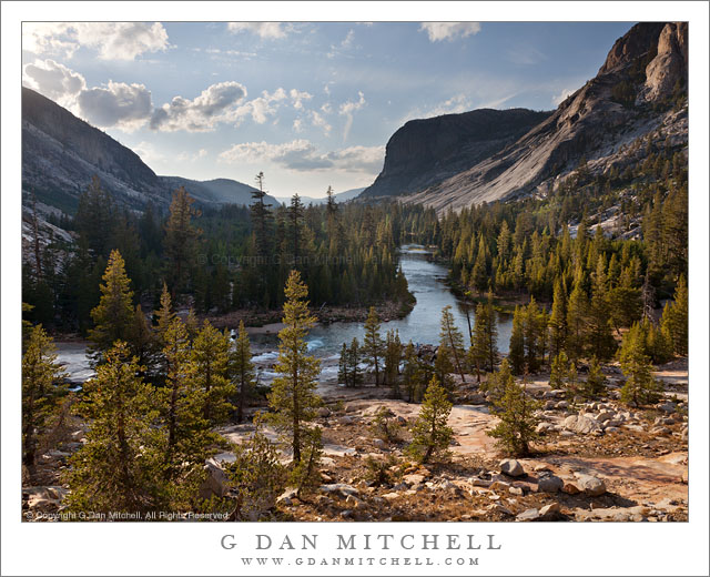
Tuolumne River Canyon Below Glen Aulin

Tuolumne River Canyon Below Glen Aulin

Tuolumne River Canyon Below Glen Aulin. Yosemite National Park, California. September 15, 2011. © Copyright 2011 G Dan Mitchell – all rights reserved.

The Tuolumne River enters Tuolumne River Canyon below the Glen Aulin High Sierra Camp.

This photograph looks west from a rocky point along the Tuolumne River just below Glen Aulin in the Yosemite National Park back-country. In September I spent a total of four nights in this specific area and photographed in and around the granite bowl that rises from the river near the foreground rocks and spreads to the right of the area shown here. The photograph was made very late in the afternoon – it had been raining when I arrived at Glen Aulin but, as often happens in the Sierra, the clouds dissipated later in the day and the skies were starting to clear before sunset.

While my favorite Sierra landscape is at the elevations where the last small trees give way to alpine tundra meadows and the rocky slopes of the highest peaks, there is also something very compelling about these lower (from my point of view) elevation areas, and especially about this particular spot along the Tuolumne. Looking west from this point along the river I had the distinct feeling that I was standing more or less on a boundary between the higher and more alpine zones (exemplified by the Tuolumne Meadows area) and the beginnings of the lower areas in which I feel like I’m heading towards the Central Valley. Here, all of the really tall peaks are behind me (OK, some are to my right…) and before me the land overall drops towards the Valley, the slightly hazy light and air of which is in the far distance in this photograph.

Making this feeling even stronger for me is the fact that very close to Glen Aulin, the Tuolumne abruptly changes from a generally meandering river that descends very gradually for the most part past large meadows and forests to one that drops precipitously into an increasingly narrow and steep canyon surrounded by granite slabs and domes and peaks that begin to take on an appearance that reminds me of Yosemite Valley.

G Dan Mitchell is a California photographer whose subjects include the Pacific coast, redwood forests, central California oak/grasslands, the Sierra Nevada, California deserts, urban landscapes, night photography, and more.
Blog | About | Flickr | Twitter | FacebookGoogle+ | 500px.com | LinkedIn | Email

Text, photographs, and other media are © Copyright G Dan Mitchell (or others when indicated) and are not in the public domain and may not be used on websites, blogs, or in other media without advance permission from G Dan Mitchell.

First Light on Zabriskie Point Hills

First Light on Zabriskie Point Hills

First Light on Zabriskie Point Hills. Death Valley National Park, California. April 3, 2009. © Copyright 2009 G Dan Mitchell – all rights reserved.

The first morning light touches hills at Zabriskie Point with ridges of the Panamint Range visible in the distance, Death Valley National Park, California.

When I visit Death Valley – typically, at least once each year – I usually try to seek out some of the less iconic scenes. However, I still do visit the icons, too. And Zabriskie Point at dawn may be the best known and perhaps the most photographed “icon” in the park. When I do go to Zabriskie it is usually for one of two reasons. First, if the light or conditions are truly special, I’ll be there with everyone else when the sun comes up! Second, I have a vague project to try to photograph aspects of Zabriskie that are different from the icon views across Gower Gulch or of Manley Beacon. This photographs sort of fits into that second category.

Those who have photographed here more than once become acquainted with the way that the morning light typically unfolds at Zabriskie. The pre-dawn light begins to softly light the entire scene, and before long the very first dawn light strikes the highest ridges of the Panamint Range on the opposite side of the Valley to the west. This light works its way down the face of that range, gradually illuminating the ridges and valleys of the range and spreading horizontally. It then begins to hit the Valley floor and works its way east and closer to Zabriskie and the rest of the ranges along the east side of the Valley. Although the closest hills are in shadow, one can almost sense the beams of light over head that are reaching into the Valley and sense that the angle of this light is gradually working down toward the closest ridges. Then the first light appears on the higher features around Zabriskie Point, at first soft but quickly increasing in intensity.

This photograph was made at this moment when that firs light arrives. The subject is a darker and rugged ridge that rises between the usual vantage points and the backdrop of the distant Panamint range, which in this photograph is somewhat obscured by the hazy atmosphere on a day when giant dust storms were just beginning to develop further north in the Valley.

G Dan Mitchell is a California photographer whose subjects include the Pacific coast, redwood forests, central California oak/grasslands, the Sierra Nevada, California deserts, urban landscapes, night photography, and more.
Blog | About | Flickr | Twitter | Facebook | Google+ | 500px.com | LinkedIn | Email

Text, photographs, and other media are © Copyright G Dan Mitchell (or others when indicated) and are not in the public domain and may not be used on websites, blogs, or in other media without advance permission from G Dan Mitchell.

Trees and Granite Cliffs

Trees and Granite Cliffs

Trees and Granite Cliffs. Yosemite National Park, California. September 15, 2011. © Copyright 2011 G Dan Mitchell – all rights reserved.

Trees ascend rocky slopes to the base of steep granite cliffs, Tuolumne River Canyon, Yosemite National Park.

There are still a few more photographs to be found among those I made during my weeklong mid-September backpack into the Yosemite back-country. I spent several days photographing in the Glen Aulin area and this is one more of the photographs from that area. In the evening the sun sets down canyon from Glen Aulin, and we had travelled to a spot where we could see down into the upper reaches of the canyon as the sun set. While I was photographing some closer subjects, I looked up and saw the light from the west back- and side-lighting trees at the upper edge of the forest before it gives way to steep granite cliffs.

One of the great pleasures of this trip was having the opportunity to spend a number of days in each location. We spent three days in this area at the start of the trip and I had the better part of two additional days on the way back to my car. In many cases, I might initially wonder how I could possibly spend that many days shooting one small area within walking distance of my camp. But many days later I had discovered more and more potential subjects… and I almost felt like I was running out of necessary time!

G Dan Mitchell is a California photographer whose subjects include the Pacific coast, redwood forests, central California oak/grasslands, the Sierra Nevada, California deserts, urban landscapes, night photography, and more.
Blog | About | Flickr | Twitter | FacebookGoogle+ | 500px.com | LinkedIn | Email

Text, photographs, and other media are © Copyright G Dan Mitchell (or others when indicated) and are not in the public domain and may not be used on websites, blogs, or in other media without advance permission from G Dan Mitchell.

Frozen Pond and Sierra Nevada Range, Owens Valley

Frozen Pond and Sierra Nevada Range, Owens Valley

Frozen Pond and Sierra Nevada Range, Owens Valley. Long Valley Area, California. October 9, 2011. © Copyright 2011 G Dan Mitchell – all rights reserved.

The snow-dusted eastern escarpment of the Sierra Nevada reflected in the surface of a frozen pond on the high desert of Owens Valley, California.

On a very cold early October morning this year I ended up driving out into Owens Valley toward the Owens River after I spotted some interesting morning fog while driving out of Mammoth Lakes on highway 395. Although I had started out with the intention of photographing aspens, when I saw the fog I changed my plans and decided to leave the aspen photography for later. I first drove to a small lake where I have photographed several times in the past, a lake that provides very still water at sunrise and great reflections of the peaks of the Sierra crest which were covered with the snow from a series of early season storms.

After sunrise I decided that I was finished at that lake, so I got back in the vehicle and went exploring on some gravel roads that wander around in the general area of Hot Creek and Owens River. At first I aimed for some ground fog-covered areas that I had spotted earlier, and for a section of creek where the warm water seems to frequently create interesting fog on cold mornings. I arrived at this creek, took a look around, and decided that it wasn’t quite what I wanted to photograph, so I kept driving, ending up on some roads I had not visited before. As I crossed one long flat area of rangeland I passed this mall frozen pond, drove a bit further, and then turned around to come back and photograph it with the early morning – but no longer dawn – like on the snow-covered peaks just south of Mammoth.

G Dan Mitchell is a California photographer whose subjects include the Pacific coast, redwood forests, central California oak/grasslands, the Sierra Nevada, California deserts, urban landscapes, night photography, and more.
Blog | About | Flickr | Twitter | FacebookGoogle+ | 500px.com | LinkedIn | Email

Text, photographs, and other media are © Copyright G Dan Mitchell (or others when indicated) and are not in the public domain and may not be used on websites, blogs, or in other media without advance permission from G Dan Mitchell.