Tag Archives: slope

Thunderstorm Over Barney Lake

Thunderstorm Over Barney Lake

Thunderstorm Over Barney Lake. Near Mammoth Lakes, California. August 5, 2005. © Copyright 2005 G Dan Mitchell – all rights reserved.

Rain from an afternoon thunderstorm begins to fall above Barney Lake, in the eastern Sierra Nevada near Mammoth Lakes, California.

This is yet another older photograph that I found again while reviewing nearly a decade of raw files recently. I actually have previously posted another similar photograph of this scene in the past, but I think this one is also effective and is somewhat different.

I came to this lake when I had to leave a group of friends with whom I was about four days into a 14-day backpacking trip in the central Sierra back in 2005. On day four I woke up feeling less that great and thought I might be coming down with some sort of “bug” that I didn’t want to deal with in the back-country, partly because we were about to enter a section of trail with no quick and easy way out, and also because I didn’t want to take a chance on slowing down or halting the rest of my party. So I bailed out on the morning of day five. The rest of the gang went south on the John Muir Trail while I backtracked to the north and exited over Duck Pass.

I recall the day fairly well – perhaps because I travelled the trail twice in two days! It was easy hiking back along the JMT to the turnoff to the pass, where I paused to enjoy the view of Duck Lake. As I began the ascent to the pass above the lake, thunderstorms quickly developed, and I recall being surprised when the rain started much more quickly and much sooner than I had predicted. I believe I had to duck (no pun intended) beneath a nearby tree and quickly take out rain gear and pack cover before moving on in the rain. After I crossed the pass and started the descent towards Mammoth Lakes, the storm moved elsewhere and rays of light broke over Barney Lake below the pass where I paused to make a few photographs of this light against the backdrop of more distant peaks and falling rain.

G Dan Mitchell Photography
About | Flickr | Twitter | FacebookGoogle+ | 500px.com | LinkedIn | Email

Text, photographs, and other media are © Copyright G Dan Mitchell (or others when indicated) and are not in the public domain and may not be used on websites, blogs, or in other media without advance permission from G Dan Mitchell.

(Basic EXIF data may be available by “mousing over” large images in posts. Leave a comment if you want to know more.)

Flooded Meadow Near Greenstone Lake

Flooded Meadow Near Greenstone Lake

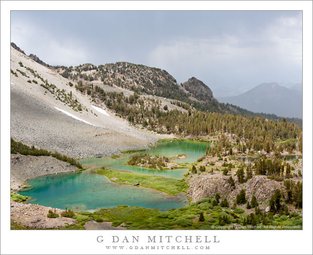
Flooded Meadow Near Greenstone Lake. Sierra Nevada, California. August 11, 2011. © Copyright 2011 G Dan Mitchell – all rights reserved.

Late-season snow fields are reflected in the pond of a flooded alpine meadow near Greenstone Lake, Sierra Nevada.

During this year of heavy and late winter snowfall, there is still a surprising amount of snow in the Sierra Nevada high country. In the upper portion of this image you can see large snow fields (with much larger ones higher on the slope and out of the frame) at that base of this talus slope at around 10,000+ feet of elevation. During a more typical year, there would still be a few scattered snow fields, but nothing like we see this year. And because there is still so much snow, the plants that would normally be well-developed by now are still just emerging, and the creeks and ponds are overflowing, the meadows are flooded… and the mosquitos are having a field day!

This little pond among the boulder-filled meadows near Greenstone Lake at the far end of Saddlebag Lake was still overflowing with snowmelt water that reflected the extensive snow fields still on the talus field beyond. To get to this spot – in mid-August! – I had to cross a number of still frozen snow fields, follow trails that were flooded in places, and pick my way carefully across waterlogged meadows. It is going to be a short summer season in the high Sierra, but as a compensatory bonus we may still see wildflowers all the way into September.

G Dan Mitchell Photography
About | Flickr | Twitter | FacebookGoogle+ | 500px.com | LinkedIn | Email

Text, photographs, and other media are © Copyright G Dan Mitchell (or others when indicated) and are not in the public domain and may not be used on websites, blogs, or in other media without advance permission from G Dan Mitchell.

(Basic EXIF data may be available by “mousing over” large images in posts. Leave a comment if you want to know more.)

Red Rock and Desert Hills

Red Rock and Desert Hills

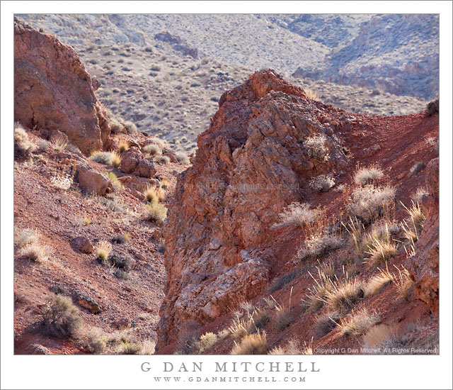
Red Rock and Desert Hills. Death Valley National Park, California. March 29, 2011. © Copyright G Dan Mitchell – all rights reserved.

A red rock gully among the desert hills of the Panamint Range, Death Valley National Park.

This is anything but an iconic image, but I think that it is emblematic of a certain type of scene that is often seen in Death Valley National Park once you get out of the main Valley and up into the hills, especially during the brief spring season when the light can be a bit softer and the plants a bit (relatively speaking!) greener.

The photograph looks up a broad valley that is visible from along the road that rises from the main road through the Valley and climbs toward the Wildrose Canyon area. Here the elevation is high enough that the dry, sun-baked flat land of the Valley is nowhere to be found. Instead this is a country of large valleys and plateaus, cut in places (mostly at the bottom of canyons) but rocky outcroppings and gullies. This red rock gully is easily visible from the road, though the odds are that most people just drive right by. I had seen it on several drives past this spot before I thought to stop and photograph it, and I was fortunate to be there when the light seemed just right.

G Dan Mitchell Photography | Flickr | Twitter | Facebook | Email
Text, photographs, and other media are © Copyright G Dan Mitchell (or others when indicated) and are not in the public domain and may not be used on websites, blogs, or in other media without advance permission from G Dan Mitchell.

Lower Slopes of Tucki Mountain, Dawn

Lower Slopes of Tucki Mountain, Dawn

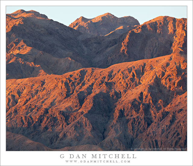
Lower Slopes of Tucki Mountain, Dawn. Death Valley National Park, California. March 31, 2011. © Copyright G Dan Mitchell – all rights reserved.

Dawn light on the faces and gullies of the lower slopes of Tucki Mountain, Death Valley National Park.

On the final morning of my recent (March, 2011) visit to Death Valley I decided to go to a spot not far from my campsite at Stovepipe Wells where I know of a bit of raised terrain that provides large-scale views of big chunks of this part of the Valley. I arrived before dawn and lugged my gear to the top of this rise with the primary plan of using a long lens to photograph across the Mesquite Dunes toward the Cottonwood Mountains at sunrise.

However, when standing in a spot like this one there are so many interesting effects of light all around that it is impossible, for me anyway, to just shoot that one thing. Far up the Valley to the north light starts to hit the highest peaks of several mountain ranges, to the east the light comes through and illuminates morning haze and layers of low hills, and to the southwest of my position the light began to reach the top of Tucki Mountain. So, between photographs of my intended subject to the west, I swung the camera though the entire 360 degrees to photograph many of these other subjects.

Tucki Mountain has fascinated me since I “discovered” it one morning while shooting on the “back side” of the Mesquite Dunes. At dawn I had been photographing the low dunes and other features on the side of the dunes that cannot be seen from the usual roadside viewpoints. As the light changed I worked my way up into the dunes a bit to photograph the shapes and textures of the sand, and I saw a composition that included this massive mountain to the south with it dark and jagged features. It was only later that I found out that it was Tucki Mountain. (If you have visited Stovepipe Wells, you have been right below the mountain.) It is a huge, sprawling peak – almost more of its own small range than a simple peak, or so it seems to me.

On this morning I first saw a big of the deep red first dawn light hitting the top of the peak and noticed lower ridges starting to pick up traces of this light. I swung that tripod head around to point this direction and decided to tightly frame some images of the overlapping ridges and valleys ascending toward the peak as the light worked its way down toward the Valley floor.

G Dan Mitchell Photography | Flickr | Twitter | Facebook | Email
Text, photographs, and other media are © Copyright G Dan Mitchell (or others when indicated) and are not in the public domain and may not be used on websites, blogs, or in other media without advance permission from G Dan Mitchell.