Tag Archives: storm

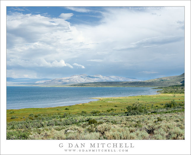
Mono Lake, Thunderstorm

Mono Lake, Thunderstorm

Mono Lake, Thunderstorm. Mono Lake, California. July 23, 2007.© Copyright 2007 G Dan Mitchell – all rights reserved.

Eastern Sierra Nevada thunderstorms build over Mono Lake, Mono Craters, and Lee Vining, California.

Mono Lake can be an unforgiving place in which to try to make photographs during the day, but sometimes one gets lucky! It is a wonderful place, but if you only know it from photographs – which, of course, tend to be made at the most appealing times – you might not know that it is often hot and hazy and dry during the day. These are among the reasons that it is a place often photographed at dawn or at sunset on days when the clouds are interesting. (The latter poses its own set of problems, since the Sierra Nevada range begins to block the light well before actual sunset.)

But I did get lucky on this late July afternoon. It was thunderstorm weather, so there were some very impressive clouds floating around. However, the clouds did not completely fill the sky, so patches of light were moving across the landscape – in this photograph one illuminates the green area at far right along the shore and, more importantly, the Mono Craters beyond the far shore of the lake. And the vegetation around the lake was still green, or at least green enough to look alive in this light.

G Dan Mitchell Photography
About | Flickr | Twitter | FacebookGoogle+ | 500px.com | LinkedIn | Email

Text, photographs, and other media are © Copyright G Dan Mitchell (or others when indicated) and are not in the public domain and may not be used on websites, blogs, or in other media without advance permission from G Dan Mitchell.

(Basic EXIF data may be available by “mousing over” large images in posts when this page is viewed on the web. Leave a comment if you want to know more.)

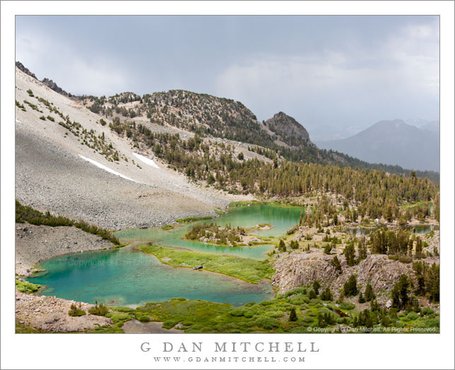
Thunderstorm Over Barney Lake

Thunderstorm Over Barney Lake

Thunderstorm Over Barney Lake. Near Mammoth Lakes, California. August 5, 2005. © Copyright 2005 G Dan Mitchell – all rights reserved.

Rain from an afternoon thunderstorm begins to fall above Barney Lake, in the eastern Sierra Nevada near Mammoth Lakes, California.

This is yet another older photograph that I found again while reviewing nearly a decade of raw files recently. I actually have previously posted another similar photograph of this scene in the past, but I think this one is also effective and is somewhat different.

I came to this lake when I had to leave a group of friends with whom I was about four days into a 14-day backpacking trip in the central Sierra back in 2005. On day four I woke up feeling less that great and thought I might be coming down with some sort of “bug” that I didn’t want to deal with in the back-country, partly because we were about to enter a section of trail with no quick and easy way out, and also because I didn’t want to take a chance on slowing down or halting the rest of my party. So I bailed out on the morning of day five. The rest of the gang went south on the John Muir Trail while I backtracked to the north and exited over Duck Pass.

I recall the day fairly well – perhaps because I travelled the trail twice in two days! It was easy hiking back along the JMT to the turnoff to the pass, where I paused to enjoy the view of Duck Lake. As I began the ascent to the pass above the lake, thunderstorms quickly developed, and I recall being surprised when the rain started much more quickly and much sooner than I had predicted. I believe I had to duck (no pun intended) beneath a nearby tree and quickly take out rain gear and pack cover before moving on in the rain. After I crossed the pass and started the descent towards Mammoth Lakes, the storm moved elsewhere and rays of light broke over Barney Lake below the pass where I paused to make a few photographs of this light against the backdrop of more distant peaks and falling rain.

G Dan Mitchell Photography
About | Flickr | Twitter | FacebookGoogle+ | 500px.com | LinkedIn | Email

Text, photographs, and other media are © Copyright G Dan Mitchell (or others when indicated) and are not in the public domain and may not be used on websites, blogs, or in other media without advance permission from G Dan Mitchell.

(Basic EXIF data may be available by “mousing over” large images in posts. Leave a comment if you want to know more.)
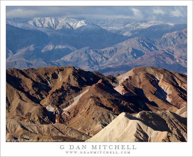
Zabriskie Point Badlands, Morning Snow on the Panamint Range

Zabriskie Point Badlands, Morning Snow on the Panamint Range

Zabriskie Point Badlands, Morning Snow on the Panamint Range. Death Valley National Park, California. February 20, 2010. © Copyright G Dan Mitchell – all rights reserved.

Morning light on fresh snow on the summit of the Panamint Range with Zabriskie Point Badlands in the foreground, Death Valley National Park.

After getting being frustrated by falling snow earlier in the morning when I tried to photograph dawn at Dantes View I headed back down to lower terrain. (Although I was not successful in photographing at Dantes View and, in fact, turned back before the summit in dense clouds and falling snow, it was quite an interesting visit!) I stopped along the way and made some photographs before arriving at Zabriskie Point.

At this point I no longer reflexively photograph at Zabriskie, though I will if something special or unusual is happening with the conditions. Having been frustrated in my original plans, I figured I might as well take a look around since I was there. I left the camera gear in my car and walked up the hill to the famous overlook to see what I could see. The dawn light – if there had even been any on this cloudy morning – was long gone, though a few photographers were still hanging out. As I looked about I noticed two things. First, the clouds were just beginning to thin over the Panamint range. While the summit of Telescope Peak was still socked in – it appeared to be snowing there – light was beginning to break through gaps in the clouds above the east side of the range and interesting shadows were appearing below the snow line. Second, the partially cloudy conditions were softening the light right in the Zabriskie/Gower Gulch area and the light in some of my favorite small gullies to the right of the observation area was looking somewhat interesting. (I have made a project of photographing them with a long lens.)

With no other specific plan, and two potential subjects right here, I followed one of those “laws of photography” that says shoot the thing you see now rather than continuing to wander around hoping that some other miracle crops up. (Sometimes this is great advice. Other times it is dead wrong!) I walked back down the hill to my car, grabbed my gear, and walked back up. I first spent some time photographing the nearby gullies. (I think I have a couple of interesting images of them that will appear here eventually.) But I quickly turned my attention to the interesting weather and light across the Valley, thinking about how I might photograph this wild and rugged scene without making it look like another Zabriskie Point image. I decided to use a relatively long focal length lens – which was already on the camera for shooting the gullies anyway – and try to fill the entire frame with a combination of close and far mountains and snow and clouds in the morning light.

G Dan Mitchell Photography | Flickr | Twitter | Facebook | Email
Text, photographs, and other media are © Copyright G Dan Mitchell (or others when indicated) and are not in the public domain and may not be used on websites, blogs, or in other media without advance permission from G Dan Mitchell.

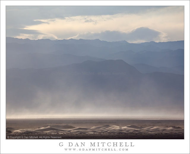
Dunes, Cottonwood Mountains, and Dust Storm

Dunes, Cottonwood Mountains, and Dust Storm

Dunes, Cottonwood Mountains, and Dust Storm. Death Valley National Park, California. February 19, 2011. © Copyright G Dan Mitchell – all rights reserved.

Afternoon winds whip up a dust storm over Death Valley between sand dunes and the high ridges of the Cottonwood Mountains.

Following my typical routine of “get up ridiculously early and shoot until I can’t stand it any longer, hang out during the middle of the day, and then head out for late afternoon and evening shooting,” I had been watching some interesting clouds developing far to the north of Stovepipe Wells during the day and decided that I might head up that way in the evening if they continued to hold promise. After crossing the Valley to the Scotty’s Castle road junction I could see a curtain of virga falling from those clouds to the north, so I decided to head that way.

The wind had been picking up from the south during the afternoon as another weather front approached. As I headed up along the edge of the main valley I could see that this wind was starting to pick up dust and sand from the Mesquite Dunes area near Stovepipe and from areas just north of that. I’m more familiar with the dust being carried south by winds out of the north, so this was a bit of a different site as sand/dust were being picked up from the dunes rather than being deposited there.

The dunes at the bottom of this photograph are not the familiar “main” dunes near Stovepipe, but are instead smaller dunes running north/south up the Valley. While a larger version of the photograph shows some blowing dust on these foreground dunes, the main cloud is coming from further south down the Valley. Beyond the dust and across the Valley are the hills of the Cottonwood range ascending to a ridge that still holds a bit of snow from storms over the previous couple of days, with building clouds above that would bring another dusting on this evening.

G Dan Mitchell Photography | Flickr | Twitter | Facebook | Email
Text, photographs, and other media are © Copyright G Dan Mitchell (or others when indicated) and are not in the public domain and may not be used on websites, blogs, or in other media without advance permission from G Dan Mitchell.