Tag Archives: terrain

Sandstone Formations, Morning

Sandstone Formations, Morning - Early morning light illuminates fins, towers, cliffs and ridges in Arches National Park, Utah
Early morning light illuminates fins, towers, cliffs and ridges in Arches National Park, Utah

Sandstone Formations, Morning. Arches National Park, Utah. April 7, 2012. © Copyright 2012 G Dan Mitchell – all rights reserved.

Early morning light illuminates fins, towers, cliffs and ridges in Arches National Park, Utah.

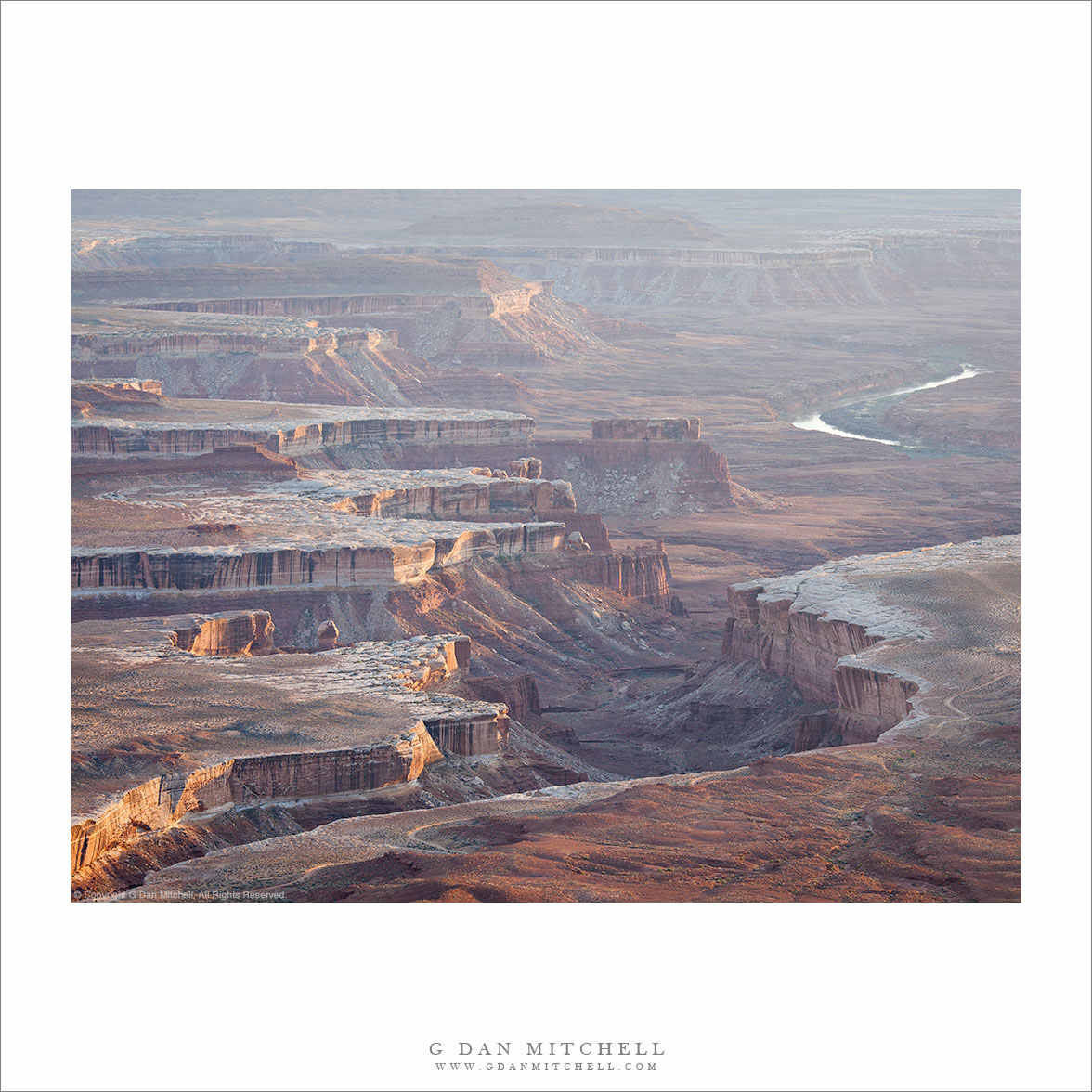
After the better part of a week photographing in Utah in early April, the day came to start the long drive back to California. But on the last morning I rose very early and made one last trip up from Moab into Arches National Park to photograph in the morning light. I started up on the ridge around the Windows area, looking for suitable sandstone formations to frame the setting full moon. (Still not sure whether or not the photographs of that subject are going to be share-able or not – we’ll see!) From there I headed back toward the Petrified Dunes area from which a panoramic view of many subjects is available – the towers and spires and arches up on the ridge near the Windows, the La Salle Mountains in the distance, and the huge sandstone formations down in the Wall Street area.

This photograph includes a more distant view of the latter area. Most often I think we view these features from close up, and look up at them from below. And when we are close to them we are more likely to consider one or perhaps a couple of them at once. However, from this elevated and more distant vantage point, the individual features and formations are seen more clearly as part of the larger landscape. From front to back there are first some isolated sandstone features standing alone and apart. Beyond them are the walls of the, well, Wall Street area, which are largely intact but have eroded away in some areas. Next there is a narrow canyon, in shadow in this photograph, and beyond that a wider and more solid wall running down from left to right. This one is thicker and there is a bit of a plateau on top where it appears that plants grow. Then there is yet another valley, another ridge, and the sequence continues on beyond the upper edge of the photograph.

G Dan Mitchell is a California photographer whose subjects include the Pacific coast, redwood forests, central California oak/grasslands, the Sierra Nevada, California deserts, urban landscapes, night photography, and more.
Blog | About | Flickr | Twitter | FacebookGoogle+ | 500px.com | LinkedIn | Email

Text, photographs, and other media are © Copyright G Dan Mitchell (or others when indicated) and are not in the public domain and may not be used on websites, blogs, or in other media without advance permission from G Dan Mitchell.

Murphy Point and Murphy Hogback, Evening

Murphy Point and Murphy Hogback, Evening - Evening light on the brow of Murphy Point, with Murphy Hogback leading to the right and the areas of the Green and Colorado Rivers confluence and the Needles beyond, Canyonlands National Park.
Evening light on the brow of Murphy Point, with Murphy Hogback leading to the right and the areas of the Green and Colorado Rivers confluence and the Needles beyond, Canyonlands National Park.

Murphy Point and Murphy Hogback, Evening. Canyonlands National Park, Utah. April 6, 2012. © Copyright 2012 G Dan Mitchell – all rights reserved.

Evening light on the brow of Murphy Point, with Murphy Hogback leading to the right and the areas of the Green and Colorado Rivers confluence and the Needles beyond, Canyonlands National Park.

When I photographed from the Green River Overlook in Canyonlands National Park back in early April, I arrived there in the evening with one shot definitely planned out ahead of time (though the conditions were, as they often are, a bit of a pleasant surprise once I arrived) and one sort of half planned. The first was a shot across the rugged terrain to the west and southwest through which the Green River has carved a deep and twisting canyon. The second was of more or less the same subject, but shot in vertical format with a longer lens and tracking some of the formations out toward the horizon.

Once there, I quickly figured out my shooting location – to be honest, there are quite a few options and unless you include cliff-top foreground subjects you don’t have to be terribly particular. I composed the first, landscape-orientation shot and then sort of went back and forth between that image and the vertical shot as the light evolved. As I did this and the low angle light began to cut through some of the haze a bit more, the terrain to my south that I had not really thought about earlier started to look a bit more interesting. From the Green River Overlook, the upper sandstone cliffs first curve back away from the river canyon, then run south, and once again extend a bit out into the canyon at Murphy Point, the impressive prominence at the left side of this photograph. One thousand feet below, Murphy Hogback – a flat-topped ridge – extends further toward the Green River. Beyond that the terrain extends into the distance, full of features that were unfamiliar to me but still very impressive – a series of plateaus, often with white rock edges, steep drop-offs into deep canyons, more distant and barely visible towers and other formations. From what I’ve read since then, I’m pretty certain that beyond the shoulder of Murphy Point, I am seeing the area roughly where the Green and Colorado Rivers meet and beyond that the area known as The Needles.

G Dan Mitchell is a California photographer whose subjects include the Pacific coast, redwood forests, central California oak/grasslands, the Sierra Nevada, California deserts, urban landscapes, night photography, and more.
Blog | About | Flickr | Twitter | FacebookGoogle+ | 500px.com | LinkedIn | Email

Text, photographs, and other media are © Copyright G Dan Mitchell (or others when indicated) and are not in the public domain and may not be used on websites, blogs, or in other media without advance permission from G Dan Mitchell.

White Rim Canyons

White Rim Canyons - Rugged canyon and plateau landscape of the White Rim area, photographed from Grand View, Canyonlands National Park.
Rugged canyon and plateau landscape of the White Rim area, photographed from Grand View, Canyonlands National Park.

White Rim Canyons. Canyonlands National Park, Utah. April 6, 2012. © Copyright 2012 G Dan Mitchell – all rights reserved.

Rugged canyon and plateau landscape of the White Rim area, photographed from Grand View, Canyonlands National Park.

I made this photograph on a day when we visited the “sky island” section of Canyonlands National Park, a high plateau fronted on many sides by steep cliffs and giant drop-offs. Since this was my first time in Canyonlands, I had a lot of reconnaissance to do before my planned evening shoot. We drove around sections of this part of the park, pausing at many overlooks to enjoy the view and consider the potential evening views. At one point we stopped at an overlook near the southern end of this section of the park to look and photograph.

The area in the photograph is the “white rim” area, where whitish colored rocks form a sort of tough terrace into which creeks have begun to carve canyons. The scale of the formations is tremendous, and the fact that two mighty rivers, the Colorado and the Green meet not too far from this point. This photograph was made well before the “ideal” golden hour time, but the low and slanting side-light and the rugged terrain of canyons and buttes seemed to compensate for that.

G Dan Mitchell is a California photographer whose subjects include the Pacific coast, redwood forests, central California oak/grasslands, the Sierra Nevada, California deserts, urban landscapes, night photography, and more.
Blog | About | Flickr | Twitter | FacebookGoogle+ | 500px.com | LinkedIn | Email

Text, photographs, and other media are © Copyright G Dan Mitchell (or others when indicated) and are not in the public domain and may not be used on websites, blogs, or in other media without advance permission from G Dan Mitchell.

Green River Canyon, Evening

Green River Canyon, Evening
“Green River Canyon, Evening” — Soft evening light on the canyon of the Green River as it winds through the desert terrain of Canyonlands National Park, Utah

I recently returned from a week in Utah which, perhaps surprisingly, was completely new to me as a photographic subject. More about that in a moment, but first a description of the photograph. It was made in Canyonlands National Park in the “Island in the Sky” area, looking west from a high viewpoint above the canyon containing the winding Green River, not far above its confluence with the Colorado River. The “Island” is a high and relatively flat plateau at around 6000+’ of elevation, surrounding on many sides by deep canyons, cliffs, and then several levels of lower plateaus. There are “edges” everywhere, and all of them provide stunning vistas into the vast spaces below and beyond. We ended up at this spot largely due to a photograph I had seen an a park brochure that included a view of receding mesas and canyons in evening light. We scouted it in the middle of the afternoon as we visited several places in this area of the park, and it seemed inevitable that I would end up at sunset. I initially imagined a scene with brighter colors from the sunset and the post-sunset sky, but instead I ended up with something that I think I like even more, namely softer light with haze in the atmosphere and somewhat gentler colors.

As I mentioned above, I have not photographed in Utah before. I had been through the state several times many years ago, but I think we more or less sped through on interstate highways – which don’t tend to follow the most scenic routes – and I had a very limited view of the place. While it is too bad that I waited so long to go there, it gave me the opportunity to have an experience that I don’t have nearly as often in California where I do most of my shooting. Because I live within a short drive of redwood forests, the Pacific coast, and places like Yosemite Valley and the Sierra and visit all of them frequently, I have to admit that I sometimes forget how extraordinary they are. I can drive right past Yosemite’s Tunnel View if the view is just a typical Yosemite Valley view. But on this trip, I more or less intentionally avoided investigating our destinations before we left. Consequently, I had opportunities to be surprised and astonished — like any good tourist! — by things that I was seeing for the first time. For example, I really had no idea what I would see at Arches National Park when we drove into it at just about the “golden hour” – and I was completely stunned by impossible structures and juxtapositions of sandstone columns and arches and towers and cliffs. I just got a quick taste on this trip… but I’ll be back.

G Dan Mitchell is a California photographer and visual opportunist. His book, “California’s Fall Color: A Photographer’s Guide to Autumn in the Sierra” (Heyday Books) is available directly from him. Blog | Bluesky | Mastodon | Substack Notes | Flickr | Email

Join the discussion — you are welcome to leave a comment or question. (Comments are moderated and may not appear immediately.)

This site uses Akismet to reduce spam. Learn how your comment data is processed.

(All media © Copyright G Dan Mitchell and others.)