Tag Archives: tuolumne

Evening Clouds, Tuolumne Meadows

Evening Clouds, Tuolumne Meadows

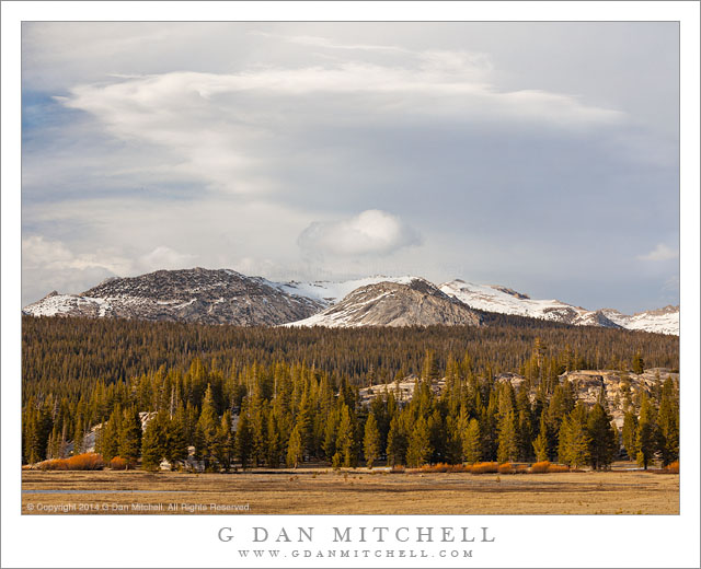
Evening Clouds, Tuolumne Meadows. Yosemite National Park, California. May 4, 2014. © Copyright 2014 G Dan Mitchell – all rights reserved.

Early season evening clouds above Tuolumne Meadows and snow-capped peaks, Yosemite National Park

Another orbit around the sun; another cycle of summer, autumn, winter, and spring; another Sierra Nevada high country summer season begins to come into view. This year’s seems to come early and leaves me with an uneasy feeling—it never really did feel like we had a winter, aside from a few stray storms here and there. But every season is different and who knows what this one will bring. Regardless, Tioga Pass Road through the Yosemite high country opened this past weekend and the high country once again became accessible, as did the eastern slopes of the Sierra. Every year when that happens, the mountains call and I must go. Sometimes, especially when the pass opens later in the season, I may have a few days and I can stay up there and explore a bit more. Other years, like the one, I have to squeeze in a quick visit between other responsibilities. But I virtually always go during the first weekend when the pass opens, and this event marks the beginning of another season that will likely stretch at least into October, when the snows fall again and the aspens change color.

The pass opened on Friday, but I had other plans and responsibilities. I had other things to do on Saturday, too, so that left Sunday. One of those Saturday activities had me returning home at about midnight, and I managed to get to bed at about 12:30… leaving just enough time for three hours of sleep before my 3:30 alarm went off. I was up, stumbling around the house in the dark to dress and make coffee, and in a half hour or so I was on the road to the Sierra. The sun rose as I entered the foothills, where I stopped to photograph some spring oak trees and green grasses, and while it was probably 7:30 or earlier when I reached the park entrance it already seemed like the day was quite far along. I turned east onto the very familiar highway 120, and eagerly watched for special places I know, looking to see how they were developing this year. Was there water in that pond? Early signs of corn lilies? Water flowing in that creek? The Sierra certainly does look dry, but this was masked a bit by the remains of a snow storm from past week, which covered the ridges with white. Eventually I made it across the range and dropped down to Mono Lake and then drove up a quiet east side canyon to sit and listen to the wind for a while before starting back. I made this photograph during the last hour of daylight in Tuolumne Meadows, as the color of the light changed and the clouds of a passing weather front assembled above the crest.

G Dan Mitchell is a California photographer and visual opportunist whose subjects include the Pacific coast, redwood forests, central California oak/grasslands, the Sierra Nevada, California deserts, urban landscapes, night photography, and more.
Blog | About | Flickr | Twitter | FacebookGoogle+ | 500px.com | LinkedIn | Email

Text, photographs, and other media are © Copyright G Dan Mitchell (or others when indicated) and are not in the public domain and may not be used on websites, blogs, or in other media without advance permission from G Dan Mitchell.

Rim Fire Zone, Morning

Rim Fire Zone, Morning

Rim Fire Zone, Morning. Rim of the World, California. October 30, 2013. © Copyright 2013 G Dan Mitchell – all rights reserved.

Hazy morning light filters across the burned hillsides in the area of the Rim Fire, California

In photographic terms this is perhaps not the most spectacular photograph, and the location is not quite a scenic icon – though it is a place that many stop and take a look on their way to Yosemite, the “Rim of the World” overlook along highway 120 between Groveland and the northern park entrance. However, this view is loaded with implications and connected to many stories.

Late this past summer, the state of California was tremendously dry after a second drought season. It wasn’t a question of whether there would be big wildfires, but more of where, when, and how many. Perhaps the biggest one of all started very near the Rim of the World overlook, and in the hot and dry conditions it quickly – some might say explosively – spread to the north, east, and south. While many think of it as “the Yosemite fire” – and it did burn a lot of terrain inside the park – it really was more of a “Yosemite area” fire. Because of the conditions – the long-term conditions of drought and the immediate conditions of heat and wind – the fire apparently did very serious damage to the forests in the are.

Shortly after the fire was contained, I thought that I might drive through the park on Tioga Pass Road to get to and from the eastern Sierra in early October. In fact, the roads had opened up again by that time, but snow closed Tioga Pass on my trip to the west and we ended up coming back over Sonora Pass. So the post-fire conditions of this area, which is very familiar to me after years of visits, were still an unknown when I drove to The Valley on October 30 for a few days of autumn photography. Passing into the first fringes of the burned areas along highway 120 things didn’t look all that different than they do after any wildfire – some areas badly burned, some singed, and others that mostly escaped the fire. I decided to stop at the Rim of the World overlook, which was pretty much the only place where stopping was allowed, and get out and take a look. I was floored by the scale of the fire. It had come from behind my position, burned down and across the deep canyon of the Tuolumne River, up the canyon walls on the far side, and then across a vast series of receding ridges. Some smoke and haze still seemed to be coming from the area, and early morning light glanced across the ridges, with their dead trees. In the far distance there is a low peak with a bit of early season snow.

I have seen quite a few fires in the park over the past few decades. One not far from here destroyed a large area of forest a few decades ago – and on this trip, ironically, I was noting that new evergreen trees are finally taking hold there. Later several very bad fires blew up from near Foresta, doing terrible damage to the section of Crane Flat Road descending towards The Valley. There have been others. In most of these cases – though I wondered in the case of the most recent Foresta fire, too – it seemed that I could watch the forest recover and return to something resembling what I remember. However, given the intensity and scale of this fire, I wonder if I’ll have that opportunity where the Rim Fire burned?

To end on a cheerier note, a couple of other observations. Even near badly burned areas, I did see sections where this fire only burned some of the vegetation and a few that seemed to have been completely spared. And when I got to a spot inside the park along highway 120 where I often stop to photography dogwood trees in the spring and fall, a spot that seemed like it might have been within the burn zone on the maps, I found my little spot completely intact, with the dogwoods turning to fall colors.

G Dan Mitchell is a California photographer and visual opportunist whose subjects include the Pacific coast, redwood forests, central California oak/grasslands, the Sierra Nevada, California deserts, urban landscapes, night photography, and more.
Blog | About | Flickr | Twitter | FacebookGoogle+ | 500px.com | LinkedIn | Email

Text, photographs, and other media are © Copyright G Dan Mitchell (or others when indicated) and are not in the public domain and may not be used on websites, blogs, or in other media without advance permission from G Dan Mitchell.

Dome and Meadow Trees

Dome and Meadow Trees

Dome and Meadow Trees. Yosemite National Park, California. August 7, 2013. © Copyright 2013 G Dan Mitchell – all rights reserved.

Beams of sunset light, shining through breaks in clouds, momentarily illuminate Tuolumne Meadows trees and the granite slopes of Lembert Dome

This is a sort of companion photograph to one I posted earlier that was taken at about the same time, but more tightly composed and focusing on just the shoulder of Lembert Dome and the slopes of Mount Dana beyond. This was one of those Sierra evenings that started out with very mediocre light, but which also held the potential for something special to happen if things were to play out just the right way. Due to a wildfire over the crest near Mammoth Lakes, the sky was quite hazy. A high layer of clouds added to the gloom. I had spent the early evening trying to find some way to photograph these conditions, but was coming up short.

Not too long before I made this photograph, I had seen the gray murk suddenly lit by the warm glow of light coming underneath the edge of the high clouds far to the west as the sun dropped toward the horizon. This is not an uncommon event when the conditions line up correctly in the high Sierra, but this time it was a bit different due to the haze. The light, which might otherwise have been so colorful and bright as to almost be beyond belief, was instead muted and softened, though no less warm. A few minutes before I shot this image, the scene had been quite different – the sun had been behind those high clouds. But as I watched this it looked to me like the sun might find its way through a gap in the clouds, so I was ready to swing my camera to the east and capture Lembert Dome and other features in this light. Here that warm evening light glances across the face of the dome and softly lights some trees at the edge of the forest around Tuolumne Meadows.

G Dan Mitchell is a California photographer and visual opportunist whose subjects include the Pacific coast, redwood forests, central California oak/grasslands, the Sierra Nevada, California deserts, urban landscapes, night photography, and more.
Blog | About | Flickr | Twitter | FacebookGoogle+ | 500px.com | LinkedIn | Email

Text, photographs, and other media are © Copyright G Dan Mitchell (or others when indicated) and are not in the public domain and may not be used on websites, blogs, or in other media without advance permission from G Dan Mitchell.

About the Yosemite “Rim” fire… and more

UPDATE and a NOTE:

Update: Shortly after I posted this, my reports on highway 120 through the park via the Tuolumne Meadows area  were rendered incorrect/outdated by way of an updated announcement from the park service as follows:

“Beginning at 12:00pm on Wednesday, August 28th, Tuolumne Meadows and the High Sierra will only be accessible via Highway 120 East through Lee Vining.  The Tioga Rd/Hwy 120 East will be temporarily closed between White Wolf Lodge and the Big Oak Flat Rd./Hwy 120 West at Crane Flat; the closure is estimated to be 3 to 4 days.  Tuolumne Meadows Lodge, the High Sierra Camps, and Tuolumne Meadows and Porcupine Flat campgrounds all remain open.”

Basically, this means that you will not be able to use highway 120 as a route across the Sierra until further notice. I’m not surprised – in fact, I’ve been somewhat surprised that the road remained open this long. Apparently the following URL is also a good source of updates from the park: http://www.yosemitepark.com/yosemite-fire-update.aspx

Note: All of which brings me back to my original statement that I don’t have inside information on this fire, and that anyone traveling to the area needs to check official sources for conditions updates. I will likely not update this page as things change, so the information posted here should be regarded as potentially being out of date!

My original post follows…

A few people have asked me for information about the “Rim” fire which started not far from Groveland near highway 120, and which is currently burning along the northwest boundary of Yosemite National Park, generally moving east and north toward the highway 108 area. While I know much of this area fairly well from many years (decades, actually) of visits, I do not have any inside information about the fire itself, nor am I an expert on wildfires. One good source of (limited but objective) information is the Stanislaus National Forest Rim Fire Incident web page. A map on this page is a quite amazing source of information, especially when combined with some familiarity with the area and a reading of various written reports. (The version on the main page seems to be based on Google Maps, and allows you to scroll around and zoom in.) Lots of folks who live and work in the area are sharing updates on the usual social media sites. The Mariposa Gazette is another local news source.

The fire started on August 17 more or less midway between Groveland and the  northwest park entrance and not far off of the highway 120 corridor near the Rim of the World area overlooking the canyon of the Tuolumne River. (Highway 120 is a common route for entry to the park from the west and northwest, and it connects via Tuolumne Meadows and Tioga Pass to the east side of the Sierra at the town of Lee Vining.) The spread of the fire at first was somewhat quick, which is no surprise given the extremely dry conditions in the Sierra following a second very dry winter and almost no real precipitation since late 2012. Then, between about August 20 and 23, the fire exploded, expanding  very quickly to cover a huge area generally to the east and north of the starting point, with the fire generally racing northeast but also spreading to the north and south. Continue reading About the Yosemite “Rim” fire… and more