Category Archives: Photographs: Utah

Cracked Mud, Canyon Light

Photo of dried mud, Utah.
“Cracked Mud, Canyon Light” — Reflected red canyon light illuminates cracked mud in a Utah wash

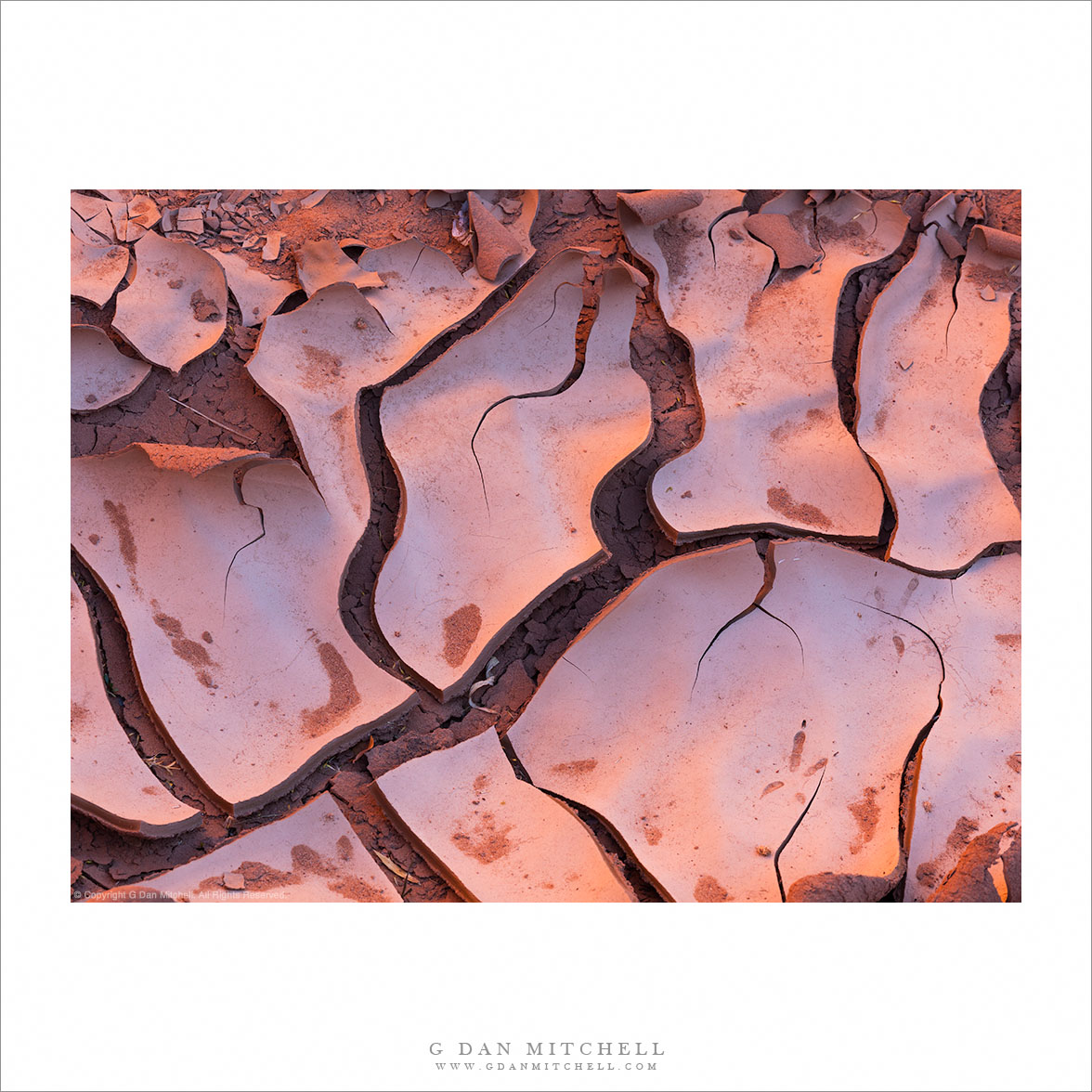
I had thought of titling this photograph “More Mud,” given that it certainly was not the only photograph I made of this subject recently. The group of us — 6 landscape/nature photographers — had set off down into a beautiful canyon, but before we dropped into the deeper section we came across this patch of trying and curling mud… and ended up stopping for a half hour or more to photograph this seemingly mundane subject.

But actually, it turns out that desert mud is often anything but mundane. When it is found in a narrow canyon with red rock walls, the mud takes on the colors of the reflected light and even a bit of the blue color from overhead open sky. In many cases, you might miss this if you were not tuned in to the light and color… but if you do see it, soon such places provide a wild range of colors. A highlight comes from overhead light reflected down into the canyon as it bounces off the red rock and takes on a very warm and red coloration.


G Dan Mitchell is a California photographer and visual opportunist whose subjects include the Pacific coast, redwood forests, central California oak/grasslands, the Sierra Nevada, California deserts, urban landscapes, night photography, and more.
Blog | About | Flickr | Twitter | FacebookGoogle+ | 500px.com | LinkedIn | Email

Text, photographs, and other media are © Copyright G Dan Mitchell (or others when indicated) and are not in the public domain and may not be used on websites, blogs, or in other media without advance permission from G Dan Mitchell.

Evening, Near Fruita

Evening, Near Fruita
“Evening, Near Fruita” — Evening light on the cliffs and hills of Capitol Reef National Park near Fruita

I had just arrived at Fruita (pronounced “Fruit-ah”) at Capital Reef National Park in the afternoon, after driving from near Kanab via a long gravel back road. After meeting a friend here and setting up camp it was late afternoon, and there was just time to head out and do some brief photography nearby before the day ended. We had an idea about heading into one of the west side canyons that are accessible by the popular (mostly) paved road, but we didn’t get nearly that far before we saw this beautiful evening light. Actually, we were probably not even a quarter-mile from the campground!

The light in this part of the park often poses a bit of a challenge late in the day. While one might look for late golden hour sun on these west-facing sandstone cliffs and peaks, the land rises from here toward the west, causing the sun to disappear from this area earlier than you might expect. But we got lucky, as broken clouds softened and warmed the light as the last sun touched these rocks just as we arrived at this spot. It is the kind of place I might usually drive past, as it is almost too obvious of a photographic location. However, I readily admit to stopping at iconic locations when the light is special, as it surely was on this evening.


Leave a comment or question using the form. (If you are reading this on the home page, click the article title to see the full article and the comment form.

G Dan Mitchell is a California photographer and visual opportunist. His book, “California’s Fall Color: A Photographer’s Guide to Autumn in the Sierra” (Heyday Books) is available directly from him. Blog | Bluesky | Mastodon | Substack Notes | Flickr | Email

All media © Copyright G Dan Mitchell and others.

Burr Trail, Strike Valley

Burr Trail, Strike Valley

Burr Trail, Strike Valley. Capitol Reef National Park, Utah. October 22, 2014. © Copyright 2014 G Dan Mitchell – all rights reserved.

The Burr Trail route as it ascends from Strike Valley towards the ridge of Capitol Reef National Park

The Burr Trail is one of the back routes through this section of Utah. It ranges from some decent paved sections to portions that are gravel and somewhat “rustic.” This is one of the latter section, at least for a short distance, as it climbs from the valley seen in the photograph to the top of a ridge behind my camera position inside Capitol Reef National Park before heading west toward Boulder.

This climb exposes some amazing geology, most of which I can only understand in the most basic of terms. This is the Waterpocket Fold area, where the strata are inclined steeply upwards as they rise to the west, and almost everywhere the evidence of these ancient layers of rock is abundant. Here the road enters a narrow canyon at the edge of the valley and soon climbs steeply up to the ridge that runs north-south for a good distance inside the national park. The view here is across the valley — with its central ridge “rib” — toward the steep cliffs on the opposite side of the valley and then rough terrain rising to mountains beyond.


G Dan Mitchell is a California photographer and visual opportunist whose subjects include the Pacific coast, redwood forests, central California oak/grasslands, the Sierra Nevada, California deserts, urban landscapes, night photography, and more.
Blog | About | Flickr | Twitter | FacebookGoogle+ | 500px.com | LinkedIn | Email

Text, photographs, and other media are © Copyright G Dan Mitchell (or others when indicated) and are not in the public domain and may not be used on websites, blogs, or in other media without advance permission from G Dan Mitchell.

Two From the Waterpocket Fold Area

I’m going to double-up here and share two photographs in a single post — both are from the Waterpocket Fold (Strike Valley) area just to the east of Capitol Reef National Park.

Waterpocket Fold, Utah

Waterpocket Fold, Utah. Capitol Reef National Park, Utah. October 22, 2014. © Copyright 2014 G Dan Mitchell – all rights reserved.

Utah’s Waterpocket fold, viewed from high in the southern part of Capitol Reef National Park

The “Waterpocket Fold” is a gigantic geologic formation in Utah, a good portion of which runs the length of Capitol Reef National Park and beyond. As I understand it, the formation is a monocline, where strata change depth at a fairly steep angle, and subsequent erosion has worn away and exposed these strata in amazing ways, especially where the up-trending layers end. This photograph, made from a high point along the ridge of Capitol Reef, looks south into the waterpocket valley as it bends and continues to head south.

Canyon with Cottonwood Trees

Canyon With Cottonwood Trees. Waterpocket Fold, Utah. October 22, 2014.© Copyright 2014 G Dan Mitchell – all rights reserved.

Cottonwood trees with autumn foliage follow a wash up a canyon toward Waterpocket Fold area cliffs

This photograph looks to the east across the strike valley of the Waterpocket Fold feature from along the ridge of Capitol Reef. A wash (which may be Bitter Creek?) winds away and upwards toward the giant cliffs along the east side of the Valley. The scene illustrates, I think, quite a few common features of this terrain. It is quite arid and rugged — except that along the bottom of the wash, which periodically floods, a long grove of cottonwood trees and other vegetation has taken hold and seems to thrive.


G Dan Mitchell is a California photographer and visual opportunist whose subjects include the Pacific coast, redwood forests, central California oak/grasslands, the Sierra Nevada, California deserts, urban landscapes, night photography, and more.
Blog | About | Flickr | Twitter | FacebookGoogle+ | 500px.com | LinkedIn | Email

Text, photographs, and other media are © Copyright G Dan Mitchell (or others when indicated) and are not in the public domain and may not be used on websites, blogs, or in other media without advance permission from G Dan Mitchell.