
Category Archives: Photographs: Utah

Sandstone Tower, Fruita District

Sandstone Tower, Fruita District

Sandstone Tower, Fruita District. Capitol Reef National Park, Utah. October 8, 2012. © Copyright 2012 G Dan Mitchell – all rights reserved.

A sandstone tower stands above the Fruita District orchards in early evening light, Capitol Reef National Park

These sandstone plateaus and mesas seem characteristic of this front-country area of Capitol Reef National Park, and they are perhaps the most striking visual icon of your approach to the park from the town of Torrey, Utah, to the west. The Fruita District is the most accessible area of the park, being right alongside the main east-west highway that passes through the park. It features some picturesque sites and sights that are enough to make almost anyone pull over and look, including the old orchards that apparently gave the area its name and the accessible petroglyphs on low cliffs that run along the road. (Although this portion of the park is quite accessible once you are out here and driving across Utah, most of the park is anything but easily accessible, and getting to other places within its boundaries can involve some very long drives on some fairly bad roads, plus some hiking. I’m fine with that! ;-)

I made this photograph late in the day, after we had done a bit of exploring along the main tourist route into the park, the largely paved road towards Capitol Gorge and other nearby points. Late in the day I happened to spot this little conjunction of creek and fall-color tree and green grass and red rock cliffs as we were about to leave the park.

G Dan Mitchell is a California photographer and visual opportunist whose subjects include the Pacific coast, redwood forests, central California oak/grasslands, the Sierra Nevada, California deserts, urban landscapes, night photography, and more.
Blog | About | Flickr | Twitter | FacebookGoogle+ | 500px.com | LinkedIn | Email

Text, photographs, and other media are © Copyright G Dan Mitchell (or others when indicated) and are not in the public domain and may not be used on websites, blogs, or in other media without advance permission from G Dan Mitchell.

Fiery Furnace, Arches National Park

Fiery Furnace, Arches National Park

Fiery Furnace, Arches National Park. Arches National Park, Utah. October 11, 2012. © Copyright 2012 G Dan Mitchell – all rights reserved.

Ridges and mesas recede into the distance beyond Fiery Furnace formations, Arches National Park.

These formations are part of a much larger set of similar structures along the road toward the Devil’s Garden area of Arches National Park. They overlook a large section of the park and beyond. The distant plateau in the sunlight is along the Colorado River, and though they are not visible in this photograph the La Sal Mountains tower even further off. Between there is a lot of rough country full of valleys and ridges and other formations.

The Fiery Furnace area contains sandstone with layers of contrasting color, as see here. This material has been eroded it all sorts of fantastical ways. On this particular day, the light conditions were both interesting and challenging. There were quite a few high clouds and a good portion of the time the sun was blocked by them and the light was somewhat dismal. But as the clouds moved along, the sun light occasionally broke through gaps and cast beams of light that traversed the landscape. When we first stopped here and saw the overcast conditions I almost decided to just move on. But I saw a few hints of this changeable light and decided to try patience first! It took a while, but eventually some of the clear areas in the overcast lined up with our position and we had moments of nice light.

G Dan Mitchell is a California photographer and visual opportunist whose subjects include the Pacific coast, redwood forests, central California oak/grasslands, the Sierra Nevada, California deserts, urban landscapes, night photography, and more.
Blog | About | Flickr | Twitter | FacebookGoogle+ | 500px.com | LinkedIn | Email

Text, photographs, and other media are © Copyright G Dan Mitchell (or others when indicated) and are not in the public domain and may not be used on websites, blogs, or in other media without advance permission from G Dan Mitchell.
Striped Rock, Grass, and Sand

Striped Rock, Grass, and Sand

Striped Rock, Grass, and Sand. Grand Staircase-Escalante National Monument, Utah. October 23, 2012. © Copyright 2012 G Dan Mitchell – all rights reserved.

A striped rock atop grasses flattened against the sand in the bottom of a slot canyon, Grand Staircase-Escalent National Monument.

I made this photograph in the first canyon we investigated during my late-October 2012 visit to Utah with photographer friends. We drove up a long gravel road and pulled off at a wide spot to find the creek that came out of this canyon, which we followed a good distance upstream. Believe it or not, this was the first time that I had hiked such a canyon and it was exciting to move from imagining the experience to actually doing it! We started out by essentially walking up the creek bed though the flats below where it left the canyon, wading through shallow water and little sand bars. Soon we entered the canyon itself and the “path” involved walking alongside the creek, frequently crossing from one side of the stream to the other to avoid obstacles, and sometimes just walking right up the stream bed, as that often provided the clearest path.

In the location where I made this photograph, the light became very red as it reflected between the upper sandstone canyon walls, and although I was shooting in the shade I had unusually warm toned light to work with. The sand here comes from – no surprise! – sandstone, and was very red in places. This bit of sand had been smoothed by the passage of higher water which had also flattened the grasses and wrapped them around this small rock with its bright red stripe.

G Dan Mitchell is a California photographer and visual opportunist whose subjects include the Pacific coast, redwood forests, central California oak/grasslands, the Sierra Nevada, California deserts, urban landscapes, night photography, and more.
Blog | About | Flickr | Twitter | FacebookGoogle+ | 500px.com | LinkedIn | Email

Text, photographs, and other media are © Copyright G Dan Mitchell (or others when indicated) and are not in the public domain and may not be used on websites, blogs, or in other media without advance permission from G Dan Mitchell.

Red Rock at Dusk

Red Rock at Dusk
Red Rock at Dusk

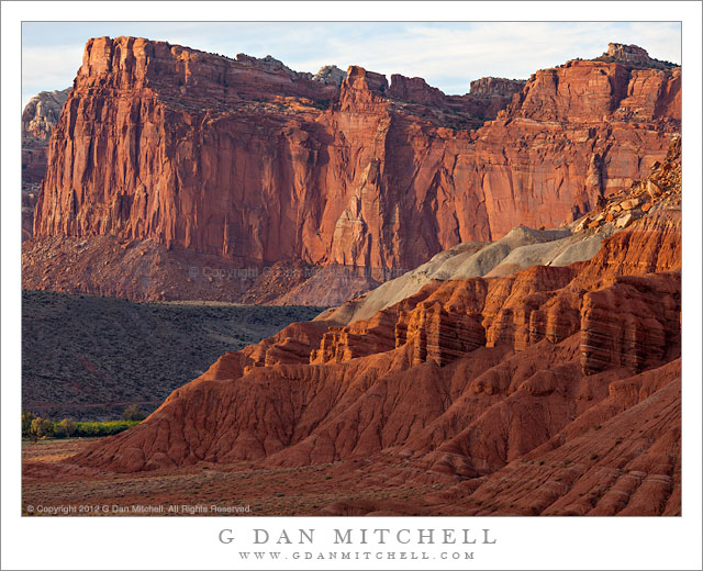
Red Rock at Dusk. Capitol Reef National Park, Utah. October 8, 2012. © Copyright 2012 G Dan Mitchell – all rights reserved.

Red rock sandstone cliffs at dusk in the Fruita area of Capitol Reef National Park, Utah.

The farther mesa or tableland is a prominent feature of the Fruita District area of Capitol Reef National Park as seen when approaching from the west – though here it is photographed from a slightly different point of view that is more to the south. There is a prominent feature – not seen in this photograph – along the upper rim of these cliffs that is known as “The Organ,” and which is pointed out in guides and maps to the area. However, I’m surprise that the spectacular cliff and mesa itself seems to either not have a name or else have a name that is not widely known. I asked about this when I was there, and several people who should know did not know of a name for it, and one suggested a name that comes from another feature that is more general.

Nonetheless, these cliffs certainly impress me, named or not! The photograph was made rather late in the day, as the sun was just about to drop above the edge of the higher country to the left/west of here. Thin clouds somewhat diffused and softened the evening light, but not so much as to remove the warm coloration of the light. Among the strata visible here is one along the low ridge at front right that contains starkly differentiated layers of lighter and darker rock. Near the far lower left corner is a small area of trees that is not far from the campgrounds of the Fruita area.

G Dan Mitchell is a California photographer and visual opportunist whose subjects include the Pacific coast, redwood forests, central California oak/grasslands, the Sierra Nevada, California deserts, urban landscapes, night photography, and more.
Blog | About | Flickr | Twitter | FacebookGoogle+ | 500px.com | LinkedIn | Email

Text, photographs, and other media are © Copyright G Dan Mitchell (or others when indicated) and are not in the public domain and may not be used on websites, blogs, or in other media without advance permission from G Dan Mitchell.