Tag Archives: afternoon

Trees and Boulders, Artist Point

Trees and Boulders, Artist Point

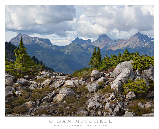
Trees and Boulders, Artist Point. Mt. Baker-Snoqualmie National Forest, Washington. August 28, 2010. © Copyright G Dan Mitchell – all rights reserved.

Ridgetop trees and boulders along the trail catch the afternoon light at Artist Point, Mt. Baker-Snoqualmie National Forest, Washington.

I had been admiring this steep, rugged, and distant ridge all afternoon, starting with our first shooting location down lower on the mountain. As we hiked up the Artist Point trail, we took a detour to the right and I noticed this low rocky ridge covered with trees and the ridge in the distance. At first I couldn’t quite see a shot and I looked elsewhere, but soon I came back to this spot and thought that something with the foreground rocks and trees along with the clouds and more distant ridge might be interesting – but as soon as I saw this a large cloud floated over and blocked the sun from my position, leaving the nearby trees and rocks in shade!

Sometimes when this happens it makes more sense to move on and look for a photograph that works with the conditions you have, but other times it can be worth waiting. It is hard to know for sure which is right, but I decided to set up and sit tight, waiting to see if the light would improve. The light shining around the edge of the cloud was tantalizingly close, but the cloud was stubborn about moving. At one point the light increased a bit for perhaps 15-20 seconds, but then quickly went away. I continued to wait. Finally, the light began to gradually increase, and I got about one minute or less of sun before the cloud again blocked the light – but this was long enough to make a few exposures of this scene.

I have a favor to ask of anyone who is familiar with this area – help in identifying the trees and, even more, help in identifying/naming the distant ridge and the peaks that sit on it. I’m not great at plant identification, but I’m really out of my league in the Cascades. One person walking by as I made the shot seemed to think that the trees are mountain hemlock – but I’d be grateful if anyone can confirm this… or set me straight. Although I was impressed with the peaks on the ridge in the distance in this photograph… I do not have any Washington topographical maps or guide books, so I’m completely in the dark about what to call this ridge or the peaks. Here, too, I would be grateful if anyone can help me identify the ridge, the peaks, and any other important features in the photograph.

Update: A Facebook reader shared information about the peaks on the distant ridge in this photograph…

Alan Majchrowicz writes: “From left to right, Tomyhoi Peak, Canadian and American Border Peaks, Larrabee Mountain. Nice photo Dan, hope I can break away this week and spend some time up there!”

This photograph is not in the public domain and may not be used on websites, blogs, or in other media without advance permission from G Dan Mitchell.

G Dan Mitchell Photography | Twitter | Friendfeed | Facebook | Facebook Fan Page | Email

Afternoon, Upper Bubbs Creek

Afternoon, Upper Bubbs Creek

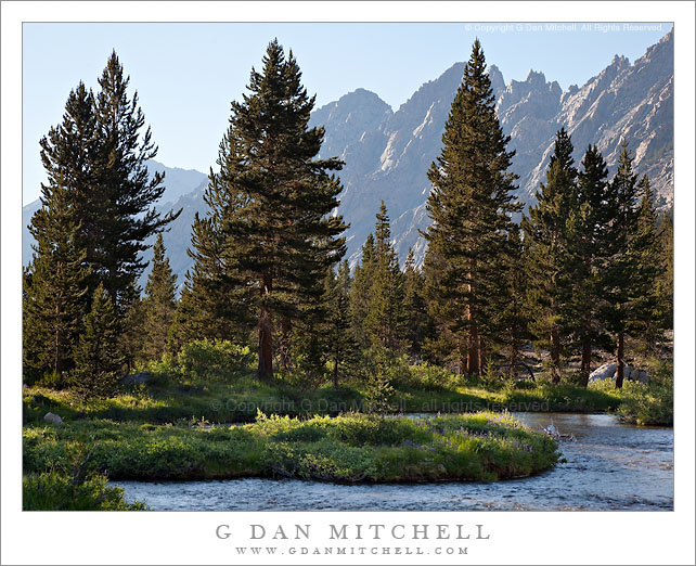
Afternoon, Upper Bubbs Creek. Kings Canyon National Park, California. July 31, 2010. © Copyright G Dan Mitchell – all rights reserved.

Late afternoon light on the forest and distant peaks on Upper Bubbs Creek, Kings Canyon National Park.

Since this photograph comes from an entirely different adventure, a bit of background information is probably in order. Among my summer pack trips, each year I join my friends from the talusdancers, a loosely connected group of folks who like to backpack, for at least one “big trip” in the Sierra. I’ve been doing this for nearly 15 years now. This year’s trip revisited some familiar spots (Tyndall Creek in the upper Kern), some that I had not visited for quite a few years (Forrester Pass), and one area that I have never before visited despite thinking about it for over 30 years (Milestone Basin and the Lake South America area). Near the end of July we headed out of Onion Valley to cross Kearsarge Pass, turned south to enter the Upper Kern River drainage via Forrester Pass, explored there for a few day, and then exited by way of brutal Shepherd Pass.

Forrester Pass is the second-highest point on the John Muir Trail (or “the JMT,” as most refer to it) at 13,200′, and we planned to cross it from north to south on the third day of our trip. At the end of day two we dropped down to Vidette Meadow and then headed up canyon to upper Bubbs Creek where the old Center Basin trail splits off from the main JMT where we made camp. This photograph was made in the late afternoon as we lazed about, doing a bit of laundry and thinking about the big climb ahead of us the next day. The view beyond the foreground and the closer trees is back down the canyon of Bubbs Creek, with the lowering sun lighting the canyon walls.

This photograph is not in the public domain and may not be used on websites, blogs, or in other media without advance permission from G Dan Mitchell.

G Dan Mitchell Photography | Twitter | Friendfeed | Facebook | Facebook Fan Page | Email
Blue Ice, Alpine Lake

Blue Ice, Alpine Lake

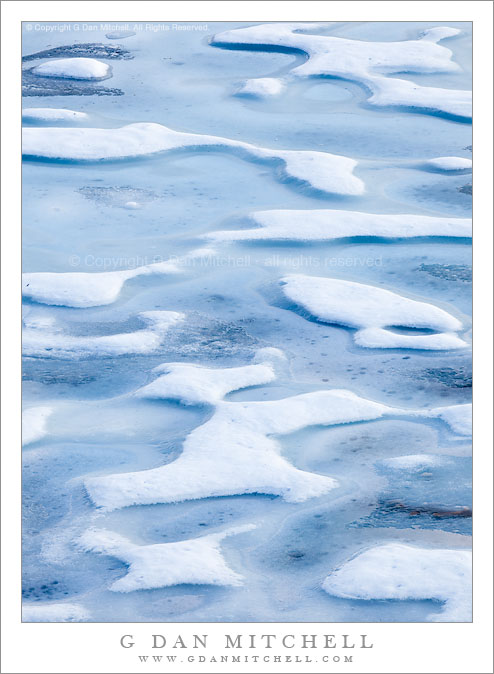
Blue Ice, Alpine Lake. Yosemite National Park, California. © Copyright G Dan Mitchell – all rights reserved.

Patterns of blue and white ice emerge as the frozen surface of an alpine lake begins to melt, Yosemite National Park.

Yes, I’m still working the series of photographs from my late June visit to a frozen alpine lake in the Tioga Pass area of Yosemite National Park – and there still may be one or two more to come. This is a tightly cropped detail of a section of the ice on the surface of this lake that was still mostly frozen, albeit in a somewhat slushy form. (Other photographs in this series play with the juxtaposition of ices and meltwater floating on the surface of the ice.) The very blue tone comes from the fact that the illumination was entirely from the very blue sky, with no direct sunlight hitting the ice at all.

This photograph is not in the public domain and may not be used on websites, blogs, or in other media without advance permission from G Dan Mitchell.

G Dan Mitchell Photography | Twitter | Friendfeed | Facebook | Facebook Fan Page | Email
Technical Data:
Canon EOS 5D Mark II
Canon EF 70-200mm f/4 L USM at 200mm
ISO 100, f/18, 1/8 second

keywords: gaylor, lake, basin, yosemite, national, park, california, usa, north america, tioga, pass, road, sierra, nevada, crest, mountain, range, alpine, blue, white, ice, frozen, melt, pattern, surface, landscape, nature, scenic, stock, tuolumne, evening, late, afternoon

Cascade, Afternoon Light

Cascade, Afternoon Light

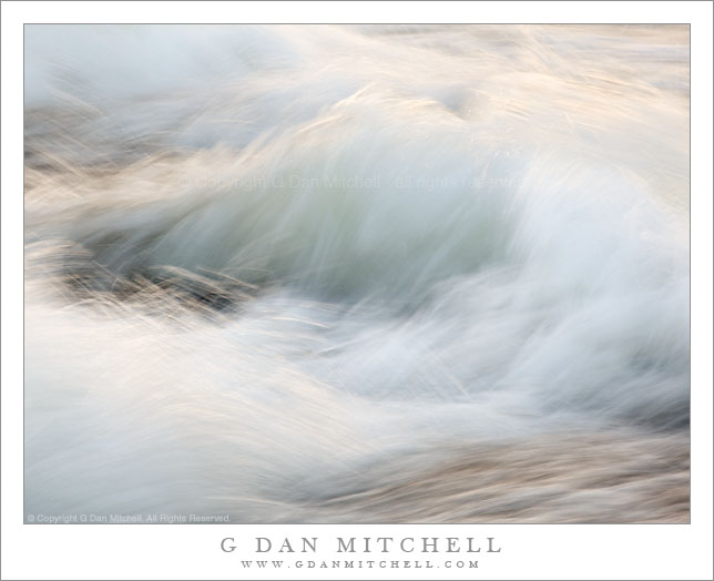
Cascade, Afternoon Light. Yosemite National Park, California. June 28, 2010. © Copyright G Dan Mitchell – all rights reserved.

A back-country creek cascades across granite in afternoon light reflected from nearby rock faces, Yosemite National Park, California.

In places where a fast-moving stream drops rapidly down a glaciated granite slope (such places are found in various locations in the Yosemite high country) and the late afternoon sunlight reflects on the far side of the stream, the water can pick up the golden color of the reflected light. In this photograph I found a standing wave in the middle of turbulent section of water, and I positioned myself so that the reflected light was directly opposite my location.

G Dan Mitchell Photography
About | Flickr | Twitter | Facebook | Google+ | 500px.com | LinkedIn | Email

Text, photographs, and other media are © Copyright G Dan Mitchell (or others when indicated) and are not in the public domain and may not be used on websites, blogs, or in other media without advance permission from G Dan Mitchell.

(Basic EXIF data may be available by “mousing over” large images in posts. Leave a comment if you want to know more.)