
Tag Archives: alpine

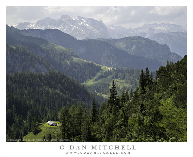
Alpine Valley, Bavaria

Alpine Valley, Bavaria

Alpine Valley, Bavaria. Near Königssee, Germany. July 18, 2013. © Copyright 2013 G Dan Mitchell – all rights reserved.

Sun dappled alpine scenery in the Bavarian Alps above Königssee, Germany

We have been traveling. After a week in London, we spent two weeks in Germany, one of which was in the Königssee area of Bavaria, Germany, where we stayed in an old farm-house. I’ll have more to say about this trip as I post more photographs over the coming days and weeks, both landscape and distinctly urban photographs. But for now, something from the Bavarian Alps.

As some of you know, I’m a long-time “Sierra Nevada guy,” who is very accustomed to hiking long distances in somewhat undeveloped areas in order to do photography. The landscape here is no less spectacular, but the experience is in many ways quite different. Take this day’s hike for example… It began with a ride on the Jennerbahn (ski lift) up to a point high up in the mountains, with scenery that reminded me in some ways of parts of “my” Sierra, but even more of some places I have visited in the Pacific Northwest. From there we hiked downhill for a kilometers, first across the top of a high ridge and then dropping down into a beautiful alpine Valley – complete with the Mahlerian sound of a chorus of cowbells. Halfway down we stopped for (fellow Sierrans, eat your heart out!) a lunch of bier und käsebrot before continuing on down to where we began at the base of the lift. The light in this part of Bavaria, at least during our visit, was very different from the clarity that I often seen in the Sierra – here the atmosphere was often thick with moisture, creating a soft quality. On this day, this was enhanced to a gradual build-up of thunderclouds that led to a spectacular evening lightning show, which we enjoyed outdoors at a picnic table back at our lodgings.

G Dan Mitchell is a California photographer and visual opportunist whose subjects include the Pacific coast, redwood forests, central California oak/grasslands, the Sierra Nevada, California deserts, urban landscapes, night photography, and more.
Blog | About | Flickr | Twitter | FacebookGoogle+ | 500px.com | LinkedIn | Email

Text, photographs, and other media are © Copyright G Dan Mitchell (or others when indicated) and are not in the public domain and may not be used on websites, blogs, or in other media without advance permission from G Dan Mitchell.

Beaver Pond, McGee Creek

Beaver Pond, McGee Creek - A beaver pond floods a low area of McGee Creek below the peaks at the edge of Pioneer Basin.
A beaver pond floods a low area of McGee Creek below the peaks at the edge of Pioneer Basin.

Beaver Pond, McGee Creek. Eastern Sierra Nevada, California. September 16, 2012. © Copyright 2012 G Dan Mitchell – all rights reserved.

A beaver pond floods a low area of McGee Creek below the peaks at the edge of Pioneer Basin.

Unlike some so-called beaver ponds in the Sierra, this one really does appear to be the home  of beavers. If you look closely near the far bank of the pond, just left of center, you can see the distinctive peaked beaver den.

This spot was a bit of a landmark on the trail up McGee Canyon on my mid-September backpack trip to Steelhead Lake. Before this the trail mostly crossed relatively dry and open terrain, but starting at this point there was more forest cover, and the valley gradually began to become more rocky and narrower. There is just a bit of early fall color in this photograph. The plants around the pond have obviously gone brown, and  some of the aspens and other brush ascending the slopes of the canyon are just barely beginning to change – what I sometimes call the “lime green” stage where it starts to become clear that the real color change is not far away. The distant tall ridge marks the boundary between the McGee Creek drainage and Pioneer Basin. I’m not positive, but I think that the two high points on the ridge might be Mounts Stanford and Crocker,  part of a group of four peaks ringing Pioneer Basin that are named after the four “railroad barons, the other two being Huntington and Hopkins.

Unlike most of my mountain photographs, this was essentially a handheld “snap” – though made with a good camera and lens. When I’m hiking I carry my camera and two lenses in a chest strap mounted front carrier so that I can make some photographs while on the move without having to remove my pack. This sort of shot, made at a time of less than optimum light, is an example of the sort of thing that I’ll occasionally shoot that way.

G Dan Mitchell is a California photographer whose subjects include the Pacific coast, redwood forests, central California oak/grasslands, the Sierra Nevada, California deserts, urban landscapes, night photography, and more.
Blog | About | Flickr | Twitter | FacebookGoogle+ | 500px.com | LinkedIn | Email

Text, photographs, and other media are © Copyright G Dan Mitchell (or others when indicated) and are not in the public domain and may not be used on websites, blogs, or in other media without advance permission from G Dan Mitchell.
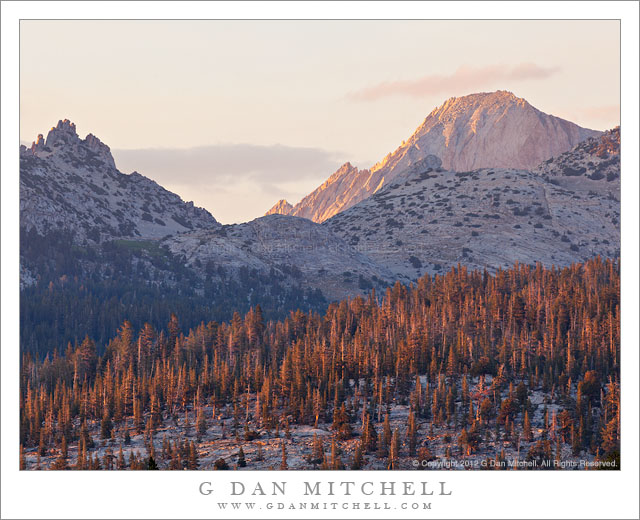
Mount Conness and Ragged Peak, Forest

Mount Conness and Ragged Peak, Forest - Evening light slants across forest below Ragged Peak and Mount Conness, Yosemite National Park, California.
Evening light slants across forest below Ragged Peak and Mount Conness, Yosemite National Park, California.

Mount Conness and Ragged Peak, Forest. Yosemite National Park, California. July 11, 2012. © Copyright 2012 G Dan Mitchell – all rights reserved.

Evening light slants across forest below Ragged Peak and Mount Conness, Yosemite National Park, California.

This photograph was made from the Tuolumne Meadows area with a long lens, and it includes the heights of Mt. Conness at the far right, the lesser prominence of Ragged Peak at the left, a shaded ridge running above the Young Lakes basin, and a closer bit of typical Yosemite forest mixed with a bit of dome-like granite, with sunset light slanting across from the left. By the way, I wondered for some time where the name “Mt. Conness” came from. I finally looked it up during the past year, and I found out that the namesake was Senator Conness, one of the two California senators during roughly the Civil War period – Conness was responsible for the legislation that initially set parts of the current Yosemite National Park aside for protection and preservation. All in all, a person deserving of a peak with his name.

Although photographed here from some distance, I know parts of the landscape encompassed by this photograph quite well, including the visible portions and some that are hidden from sight in this photo. For a number of years I have made a habit of visiting the Young Lakes area at least once each season, often late in the season when the summer crowds have dissipated – though I have also visited very early in the season, and I have the mosquito stories to prove it! Young Lakes lie on the other side of the shaded ridge traversing the center of the photograph, and I’ve often looked up at that ridge from the lakes. I have also hiked up into the valley on this side of the ridge. The trail to Young Lakes crosses the wooded area beyond the sunlit trees and passes through a beautiful semi-meadow area below Ragged Peak, a place where beautiful lupine flowers may be found at the right time of the year and from where one can obtain some panoramic views of a lot of high Yosemite Peaks. On one of my first visits to Young Lakes, it was so late in the season that the backcountry ranger who was patrolling the area apparently had little to do, and one morning we ended up having a very long conversation along the shore of one of the lakes. I remarked that a particular little gully in roughly the area of Ragged Peak looked like it might be interesting, and he shared enough information about the route that I chose to use it rather than the regular trail on my return to the trailhead. Mt. Conness, here the only peak or ridge still fully in sunlight, towers above everything else in this area. I have not climbed it, though I have investigated some trail less areas around its base and I’ve looked at it from almost every side.

G Dan Mitchell is a California photographer whose subjects include the Pacific coast, redwood forests, central California oak/grasslands, the Sierra Nevada, California deserts, urban landscapes, night photography, and more.
Blog | About | Flickr | Twitter | FacebookGoogle+ | 500px.com | LinkedIn | Email

Text, photographs, and other media are © Copyright G Dan Mitchell (or others when indicated) and are not in the public domain and may not be used on websites, blogs, or in other media without advance permission from G Dan Mitchell.

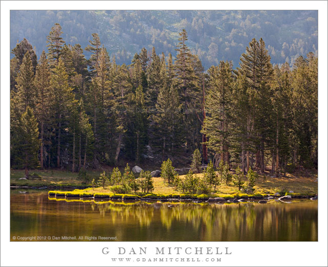
Morning Light, Tioga Tarn

Morning Light, Tioga Tarn - Morning light, shining over the shoulder of Mount Dana, strikes a shoreline meadow along one of the Tioga tarns, Yosemite National Park.
Morning light, shining over the shoulder of Mount Dana, strikes a shoreline meadow along one of the Tioga tarns, Yosemite National Park.

Morning Light, Tioga Tarn. Yosemite National Park, California. July 13 2012. © Copyright 2012 G Dan Mitchell – all rights reserved.

Morning light, shining over the shoulder of Mount Dana, strikes a shoreline meadow along one of the Tioga tarns, Yosemite National Park.

I’m pretty much completely unable to resist making photographs of trees back-lit by morning light, especially when they are in meadowy areas along the shorelines of sub-alpine or alpine lakes. The condition is even worse when the water reflects the backlit trees, and almost unbearable when the light also illuminates some of the shapes below the water’s surface. It is a personal weakness. I freely admit it! ;-)

I made this photograph early one morning, but not too early, in the general area of Tioga Pass. The high country on both sides of the pass contains quite a few small seasonal ponds filled by snow-melt water. Many are shallow and many, but not all, are partially to completely surrounded by meadow. Often small trees may grow in the meadow areas along the banks of the tarns, with the old explanation being that they are “gradually filling in the meadows,” though I’ve also heard that they find it harder to grow in these areas because of the higher water table. I made this photograph with a rather long lens. In some ways it might have been better to work closer to the trees and use a shorter lens, but here it was also a better idea to use the long lens to protect the area surrounding the tarn, an area that is perhaps just a bit too accessible to visitors and which needs a bit of additional care and protection. By the way, if you want to see green high country scenes like this one, you’ll have to go very soon this year! After a very dry winter, much of the water is already drying up in the high country and the meadows that would typically be at their height of green right about now are already turning brown quickly.

G Dan Mitchell is a California photographer whose subjects include the Pacific coast, redwood forests, central California oak/grasslands, the Sierra Nevada, California deserts, urban landscapes, night photography, and more.
Blog | About | Flickr | Twitter | FacebookGoogle+ | 500px.com | LinkedIn | Email

Text, photographs, and other media are © Copyright G Dan Mitchell (or others when indicated) and are not in the public domain and may not be used on websites, blogs, or in other media without advance permission from G Dan Mitchell.