Tag Archives: Cloud

Migration

Migration
Migration

Migration. San Joaquin Valley, California. March 9, 2013. © Copyright 2013 G Dan Mitchell – all rights reserved.

Ross’s geese fly across a cloud-filled late winter sky, San Joaquin Valley

By all of the usual standards, this was a spectacularly beautiful weekend here in the San Francisco Bay Area of Northern California. Yesterday the temperature reached into the low seventy-degree range as I drove up US-5 from one photography location to another. People were wearing shorts. Daylight savings time began today (and I’ll complain about that elsewhere! ;-) and the light feels like it lasts an hour longer. The weeds are coming up in our garden, but that means that we’ll have a vegetable garden again before long.

I imagine that anyone reading this who lives in a place with real winter won’t understand this, but I have mixed feelings about the end of winter. I’m much more interested in the extremes of winter weather, and every spring I realize that it will likely be months until I again see 30+ foot waves along the Pacific coast, new snow in the Sierra, a good rain storm, or the arrival of migratory birds in the Central Valley. The main purpose of this weekend’s drive around the San Joaquin Valley, the lower Sacramento Valley, and areas of the delta was to visit those birds one more time before the marshes dry up and the birds head back to the north. I made this photograph in the morning when, to my surprise, what started out looking like a clear spring-like day turned foggy and more like winter. The birds were still there – and in large numbers in many places – and at one point lines of them flew in front of this cloud for several minutes.

G Dan Mitchell is a California photographer and visual opportunist whose subjects include the Pacific coast, redwood forests, central California oak/grasslands, the Sierra Nevada, California deserts, urban landscapes, night photography, and more.
Blog | About | Flickr | Twitter | FacebookGoogle+ | 500px.com | LinkedIn | Email

Text, photographs, and other media are © Copyright G Dan Mitchell (or others when indicated) and are not in the public domain and may not be used on websites, blogs, or in other media without advance permission from G Dan Mitchell.

Morning Haze, Death Valley

Morning Haze, Death Valley

Morning Haze, Death Valley. Death Valley National Park, California. March 30, 2011. © Copyright 2013 G Dan Mitchell – all rights reserved.

Distant snow-covered peaks are barely visible across the vast space of Death Valley in hazy morning light

This photograph was made from Dantes View, high in the mountains along the eastern border of Death Valley itself, and with a commanding, panoramic view of a huge portion of the surrounding terrain and especially down into Death Valley and the Badwater area almost right beneath the peak. The view here looks roughly north or northwest, past the location of Furnace Creek and beyond the Mesquite Dunes area to the far northern end of the Valley and then beyond to distant snow-covered peaks.

I have written before that Dantes View has been a difficult place for me to photograph. At first glance, the location has a lot going for it. At about a mile above the Valley floor below, the views encompass a huge area of interesting terrain, ranging from the lowest reaches of Death Valley itself to the 11,000+” Telescope in the Panamint Range to other features so distant that they often fade into the haze. But for me these same features make it very difficult to pick out anything that can draw the larger components of the scene together. There have been times when I have gone there with the intention of photographing, gotten out, looked around, been impressed by the location, and made no photographs at all. This time I mostly shot details of the Valley using a very long lens, but I thought that the shadows of the passing clouds brought enough relieve to the uniformity of the Valley to make this photograph, which I hope conveys some sense of the scale of the place.

G Dan Mitchell is a California photographer and visual opportunist whose subjects include the Pacific coast, redwood forests, central California oak/grasslands, the Sierra Nevada, California deserts, urban landscapes, night photography, and more.
Blog | About | Flickr | Twitter | FacebookGoogle+ | 500px.com | LinkedIn | Email

Text, photographs, and other media are © Copyright G Dan Mitchell (or others when indicated) and are not in the public domain and may not be used on websites, blogs, or in other media without advance permission from G Dan Mitchell.

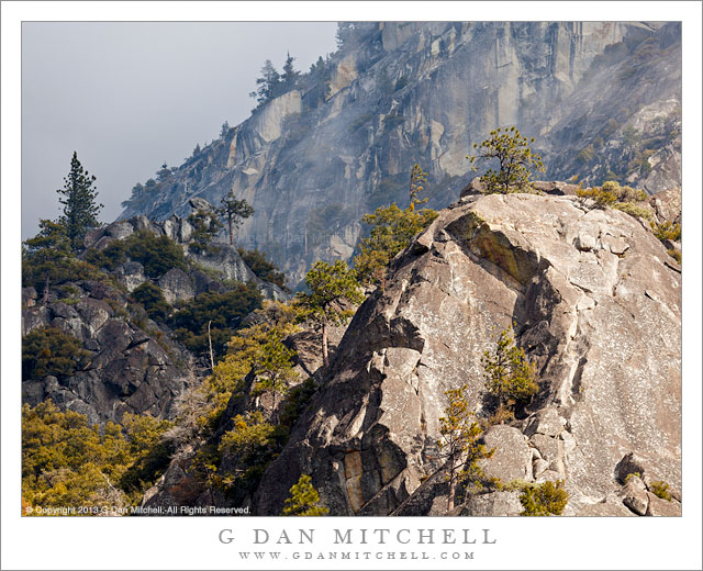
Granite, Mist, and Trees

Granite, Mist, and Trees

Granite, Mist, and Trees. Yosemite Valley, California. February 23, 2013. © Copyright 2013 G Dan Mitchell – all rights reserved.

A momentary beam of sunlight illuminates a granite outcropping and trees against a backdrop of clouds surrounding the upper cliffs of Yosemite Valley

We had one day in the Valley and despite challenging weather conditions were determined to make photographs. I knew that it was likely to be cloudy, but there was also light rain (and snow at slightly higher elevations), making it a rather gray day. However, in some ways these can be among my favorite conditions to photograph here. When it is cloudy or stormy in the Valley, clouds can drift among the feature high up on the surrounding cliffs and peaks, and sometimes there can be fog and other kinds of interesting atmosphere right down in the Valley – and I feel that these conditions are both more interesting and more challenging that a classic “beautiful day” in the Valley. (Not that I won’t take one of those, too, if it turns out to be available.)

Looking for interesting subjects we headed west on Northside Drive and found clouds obscuring the face of El Capitan, blowing enough that they would momentarily reveal sections of the giant granite face. We stopped at one of the locations from which hordes of photographers would attempt to photograph Horsetail Fall later that evening and I made a few photographs of this foggy sight, but then I turned a long lens towards other sections of the steep terrain above the Valley, looking for sections where interesting things might happen as the clouds drifted around and occasional sun broke through. As I lined up a composition that included various diagonals from rocky prominences and cliffs rising above, the sun began to shine weakly through the clouds and light up the closest rock while those beyond remained mostly gray.

G Dan Mitchell is a California photographer and visual opportunist whose subjects include the Pacific coast, redwood forests, central California oak/grasslands, the Sierra Nevada, California deserts, urban landscapes, night photography, and more.
Blog | About | Flickr | Twitter | FacebookGoogle+ | 500px.com | LinkedIn | Email

Text, photographs, and other media are © Copyright G Dan Mitchell (or others when indicated) and are not in the public domain and may not be used on websites, blogs, or in other media without advance permission from G Dan Mitchell.
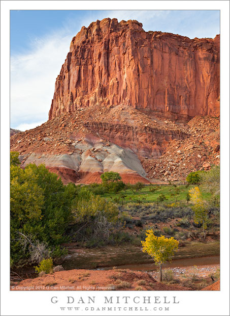
Sandstone Tower, Fruita District

Sandstone Tower, Fruita District

Sandstone Tower, Fruita District. Capitol Reef National Park, Utah. October 8, 2012. © Copyright 2012 G Dan Mitchell – all rights reserved.

A sandstone tower stands above the Fruita District orchards in early evening light, Capitol Reef National Park

These sandstone plateaus and mesas seem characteristic of this front-country area of Capitol Reef National Park, and they are perhaps the most striking visual icon of your approach to the park from the town of Torrey, Utah, to the west. The Fruita District is the most accessible area of the park, being right alongside the main east-west highway that passes through the park. It features some picturesque sites and sights that are enough to make almost anyone pull over and look, including the old orchards that apparently gave the area its name and the accessible petroglyphs on low cliffs that run along the road. (Although this portion of the park is quite accessible once you are out here and driving across Utah, most of the park is anything but easily accessible, and getting to other places within its boundaries can involve some very long drives on some fairly bad roads, plus some hiking. I’m fine with that! ;-)

I made this photograph late in the day, after we had done a bit of exploring along the main tourist route into the park, the largely paved road towards Capitol Gorge and other nearby points. Late in the day I happened to spot this little conjunction of creek and fall-color tree and green grass and red rock cliffs as we were about to leave the park.

G Dan Mitchell is a California photographer and visual opportunist whose subjects include the Pacific coast, redwood forests, central California oak/grasslands, the Sierra Nevada, California deserts, urban landscapes, night photography, and more.
Blog | About | Flickr | Twitter | FacebookGoogle+ | 500px.com | LinkedIn | Email

Text, photographs, and other media are © Copyright G Dan Mitchell (or others when indicated) and are not in the public domain and may not be used on websites, blogs, or in other media without advance permission from G Dan Mitchell.