Tag Archives: death valley

Salt Flats and Sunset Clouds – Near Badwater

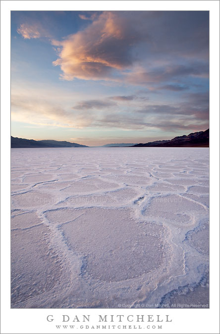
Salt Flats and Sunset Clouds - Near Badwater

Salt Flats and Sunset Clouds – Near Badwater. Death Valley National Park, California. March 29, 2010. © Copyright G Dan Mitchell – all rights reserved.

Sunset clouds above the patterned salt flats near Badwater, Death Valley National Park, California.

This photograph was made in the evening at the “secret” spot on the salt flats just south of Badwater. Reports and photographs from this location a couple weeks ago indicated that it had been flooded by earlier heavy rains, but by the time of my visit there was little standing water left here, with the exception of a few open spots (one seen in the middle distance on the salt flats) – though it did appear that the flats might still be wet beneath the salt crust. Walking on this was an odd experience that reminded me a bit of walking on newly frozen winter ice. The appearance of the salt flats was quite changed by the water. Typically the ridges between the flat “polygon” sections of the salt are more distinct, being as tall as a few inches and sometimes almost seeing to break over one another like the edges of ice floes. But at this stage the flats are almost, well, flat.

Shooting this scene in the evening often provides a few technical challenges. In the past I’ve shot from a lower camera position in order to get a closer view of the salt. This time I decided to place the camera bit higher so that I could capture a larger expanse of the salt flat texture. Another issue is the color of the salt. We “know” that salt is white, and when one walks on the playa it registers as white to the eyes/mind. But if you observe carefully – or look at a photograph later – you find out that this salt is anything but white, mostly because it is illuminated entirely by the open sky and therefore picks up the sky coloration. When the sky is clear the salt can become so blue that corrections are needed, in my opinion, during post-processing. On this evening the blue was not as pronounced since the colorful clouds balanced it out to some extent. A third issue is the tremendous dynamic range of the scene, ranging from some very bright sky below the clouds near the left side of the frame, through the much less brightly-lit salt flat, to the very dark foothills on the horizon at the right. In order to manage this I had to do two things. First, instead of using a graduated neutral density filter to lighten the foreground and control sky brightness, I made two exposures one stop apart and combined them in post. Secondly, I used layers to separately adjust sections of the image, primarily differentiating between the salt (which need to be lightened up a bit) and the sky (where the brightest areas needed to be controlled).

This photograph is not in the public domain and may not be used on websites, blogs, or in other media without advance permission from G Dan Mitchell.

G Dan Mitchell Photography | Twitter | Friendfeed | Facebook | Facebook Fan Page | Email

Technical Data:
Canon EOS 5D Mark II
Canon EF 17-40mm f/4 L at 17mm
ISO 100, f/16, composite: 1/6 second and 0.3 second

keywords: badwater, salt, flats, polygon, pattern, playa, death valley, national, park, california, usa, north america, evening, dusk, sunset, cloud, colorful, pink, orange, blue, sky, landscape, nature, light, travel, scenic, geology, mountains, stock

Amargosa Range and Transverse Dunes, Sunset

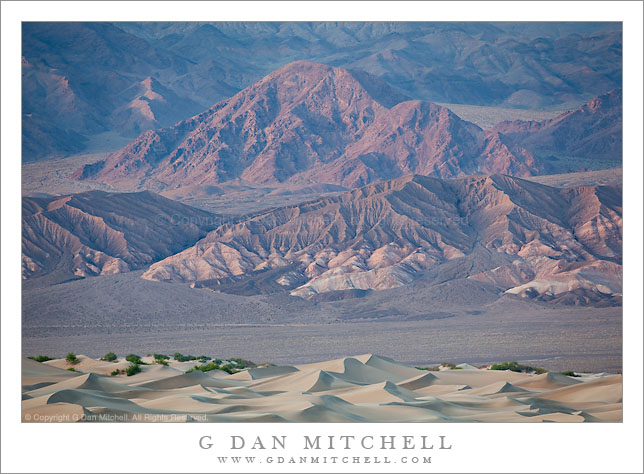
Amargosa Range and Transverse Dunes, Sunset

Amargosa Range and Transverse Dunes, Sunset. Death Valley National Park, California. March 26, 2010. © Copyright G Dan Mitchell – all rights reserved.

Sunset light on lower reaches of the Amargosa Range and the Kit Fox Hills above the Transverse Dunes, Death Valley National Park, California.

The Amargosa Range lies east of Death Valley and the Death Valley Dunes, and its foothills (called the “Kit Fox Hills,” if I’m not mistaken) here from a backdrop for the “transverse dunes,” the lower eastern portion of the Death Valley Dunes near Stovepipe Wells. The dunes turn all sorts of interesting colors at and just after sunset on evenings when the light is just right, and the evening light brings out colors in the further hills and gullies that are generally washed out in the harsh midday light.

To get an idea of the scale of the scene consider that the photograph was made with a rather long focal length of nearly 400mm and that the very subtle line along the base of the hills is the roadway running north towards Scotty’s Castle. Walking out to the dunes along the lower edge of the photograph might take a half hour or so.

This photograph is not in the public domain and may not be used on websites, blogs, or in other media without advance permission from G Dan Mitchell.

G Dan Mitchell Photography | Twitter | Friendfeed | Facebook | Facebook Fan Page | Email

Technical Data:
Canon EOS 5D Mark II
Canon EF 100-400mm f/4.5-5.6 L IS USM at 370mm
ISO 200, f/8, 1/50 second

keywords: kit fox, hills, mountains, amargosa, range, alluvial, fan, desert, transverse, dunes, mesquite, gully, geology, grapevine, foothills, shadow, sunset, dusk, wash, evening, death valley, national, park, california, usa, north america, travel, scenic, wilderness, landscape, nature, barren, light, stock

Moving Rock, Overcast Morning Sky – Racetrack Playa

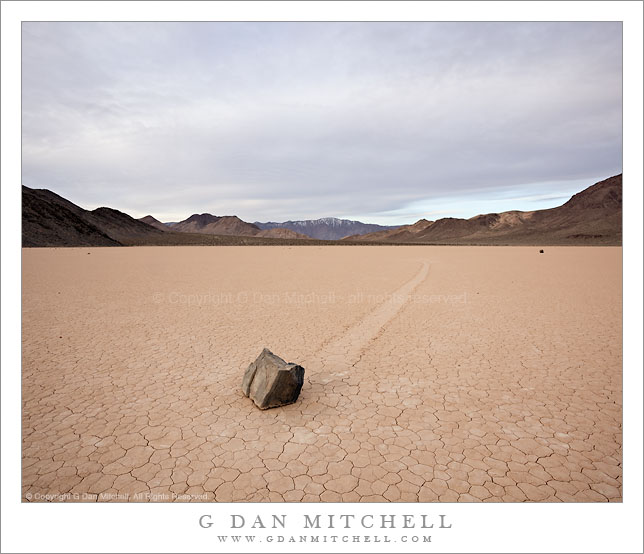
Moving Rock, Overcast Morning Sky - Racetrack Playa

Moving Rock, Overcast Morning Sky – Racetrack Playa. Death Valley National Park, California. March 29, 2010. © Copyright G Dan Mitchell – all rights reserved.

A “moving rock” beneath overcast morning skies at the Racetrack Playa, Death Valley.

First a bit of background about “the Racetrack,” the location of the famous “moving rocks” in Death Valley National Park. About 25 miles out in the desert back-country of the park on a very bad gravel road there is an isolated and desolate playa known as “the Racetrack.” (For those considering a visit, getting to the Racetrack is no trivial matter. The drive takes nearly two hours one-way and the road is awful, with some of the worst wash-board surface I’ve ever encountered. There are absolutely no services along the road or at the Racetrack – no water is available and your cell phone won’t work.) The name of the place comes, in some circuitous way, from the mysterious rocks that have clearly traveled across the playa, sometimes many hundreds of yards, and left tracks gouged into the playa surface. The most likely explanation for the phenomenon involves a combination of a periodically flooded playa, extremely high winds, and rare occasions when it is cold enough to freeze the surface of collected water, locking the rocks in place and allowing the wind to move them. I’ve never heard anything concrete about the frequency of this alignment of conditions, but as far as I know no one has ever observed the rocks actually moving, nor is there any indication that they have moved recently.

I’ve been out there three times in the past, and had great conditions for doing photography. On this visit I had plans to photograph in sunset and sunrise light and to attempt night photography of the rocks under the full moon. (I did the latter once before, but was less familiar than I am now with how to best do this with a DSLR.) Since I’ve had such good luck with weather and lighting conditions in the past, I suppose I was due for less than optimum conditions… and that is what I encountered. Shortly after arriving at the playa the sky was covered by high, thin clouds. Except for a brief moment close to sunset this made late day photography difficult. The overcast stuck around until I left then next morning, making the planned full moon night photography an impossibility, and the morning light was also challenging.

That said, I’m still glad I went. Standing in the middle of this empty playa completely alone as the day ends or begins is an amazing experience that few people get to have. And I did manage to bring back a few photographs that I think will “work.” This one was shot fairly early in the morning at what might have been around sunrise, if a sunrise had actually occurred.

This photograph is not in the public domain and may not be used on websites, blogs, or in other media without advance permission from G Dan Mitchell.

G Dan Mitchell Photography | Twitter | Friendfeed | Facebook | Facebook Fan Page | Email

Technical Data:
Canon EOS 5D Mark II
Canon EF 17-40mm f/4 L at 17mm
ISO 200, f/16, 1/8 second

keywords: moving, sliding, rock, race, track, racetrack, playa, death valley, national, park, california, usa, north america, morning, cloudy, sky, earth, cracked, dry, arid, desert, mountain, snow, covered, inyo, landscape, nature, travel, scenic, mystery, track, trail, phenomenon, lippencott, mine, road, stock

Rock Patterns, Mosaic Canyon

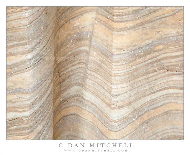
Rock Patterns, Mosaic Canyon

Rock Patterns, Mosaic Canyon. Death Valley National Park, California. March 27, 2009. © Copyright G Dan Mitchell – all rights reserved.

Folded and twisted rock forms in Mosaic Canyon, Death Valley National Park, California.

Although this formation is found very near the entrance to the canyon, on this visit I also managed to wander further up the canyon than I have in the past, discovering very different and far more open terrain that what I had seen before. Mosaic Canyon, a short drive up the hill from Stovepipe Wells, is known for its very narrow and twisty lower section, its access to higher regions of the Mount Tucki area, and the striking and unusual rock formations laid bare by erosion from water traveling down the canyon in past floods.

In the lower canyon there is a section where this beautifully banded rock runs alongside the trail. Sometimes that patterns are a bit hard to see, but this time it appeared that recent rains and the soft afternoon shaded light brought them out a bit more. This section featured ribbon-like folds in the surface of the rock that must have been created by water erosion.

This photograph is not in the public domain and may not be used on websites, blogs, or in other media without advance permission from G Dan Mitchell.

G Dan Mitchell Photography | Twitter | Friendfeed | Facebook | Facebook Fan Page | Email

Technical Data:
Canon EOS 5D Mark II
Canon EF 24-105mm f/4 L IS USM at 105mm
ISO 100, f/11, 1/8 second

keywords: death valley, national, park, california, usa, north america, scenic, travel, nature, desert, mosaic, canyon, trail, rock, pattern, fold, twist, geology, groove, curve, crack, pink, abstract, texture, nature, erosion, travel, scenic, stock