Tag Archives: exposed

A Photograph Exposed: A Tale of Light

(“A Photograph Exposed” is a series exploring some of my photographs in greater detail.)

On the weekend of June 18-19 of this year I made a point of getting to Yosemite so that I could photograph the high country on the first day that Tioga Pass Road was open for the season. On a shoot like this, my subjects range from some that I planned to shoot ahead of time to some that were completely unanticipated. Among the many things that might affect my decisions is the light itself, and this is a story about that light… and perhaps a few other things, too.

I had driven to the park very early on Saturday morning and after photographing straight through the morning I finally made it over the pass and headed down to Lee Vining Canyon to find a campsite for that night. After getting up at 3:30 a.m. and driving to the Sierra from the SF Bay Area and then shooting all morning, I was exhausted! I pulled into the first available site, paid my fee, and promptly fell asleep in the car for perhaps an hour. When I woke up I set up my camp and at about 3:00 or so headed down to Lee Vining to get some “dinner” – on “photographer time,” dinner tends to either be very early or very late, and on this day I made it early so that I could be back up in the park well before the “good light” started.

Heading back up to Tioga Pass after my mid-afternoon dinner, I had a few subject ideas in mind. Tuolumne Meadows itself was one possibility, and I knew that I wanted to watch for any cascades or creeks that would be flowing in the spring snow-melt conditions. Tenaya Lake was another possibility, and a client’s interest in photographs of Mount Conness had me thinking about the possibility of a photograph from Olmsted Point that included ice-covered Tenaya Lake and this peak. Continue reading A Photograph Exposed: A Tale of Light

Black Point and Negit Island, Mono Lake Shoreline

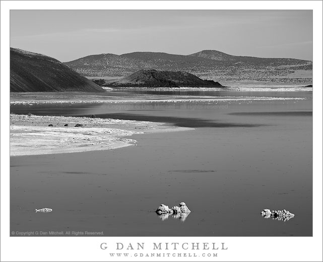
Black Point and Negit Island, Mono Lake Shoreline

Black Point and Negit Island, Mono Lake Shoreline. Mono Lake, California. October 10, 20120. © Copyright G Dan Mitchell – all rights reserved.

The north shoreline of Mono Lake leads from foreground offshore tufa past the base of Black Point to Negit Island and beyond.

You would never know it from this black and white photograph of the austere desert landscape around Mono Lake, but I was there to photograph… fall aspen color! Earlier in the day I had photographed further south along the eastern slopes of the Sierra, gradually working my way north with a plan of heading back to the “west side” over Tioga Pass at the end of the day after doing a last bit of  fall color photography near Conway Summit and Dunderberg Road in late-afternoon light. By mid-afternoon I had made it to Lee Vining for an espresso stop at Latte Da and a break to check some email and so forth. Soon it was time to get into position for the low angle sun that would light the aspens a bit later, so I headed north out of town.

The road north from Lee Vining skirts the west shore of Mono Lake. Before leaving the lake there is a turn-off to another road that passes along the north shore of Mono Lake and can take you to places such as Black Point. I often stop at this turn-off since it provides a slightly elevated view of the larger terrain around the lake including the low hills to the east and Mono Craters and higher mountains to the south. On a typical blue sky mid-afternoon I might not make any photographs, but something about the light and the forms of the shoreline, Black Point, and Negit Island leading into the distance convinced me to make a few exposures, using a long lens to compress the distance.

This photograph is not in the public domain and may not be used on websites, blogs, or in other media without advance permission from G Dan Mitchell.

G Dan Mitchell Photography
Flickr | Twitter | Facebook Fan Page | Facebook | Friendfeed | Email

A Photograph Exposed: “Submerged Boulders, Lake, and Cliffs”

(“A Photograph Exposed” is a series exploring some of my photographs in greater detail.)

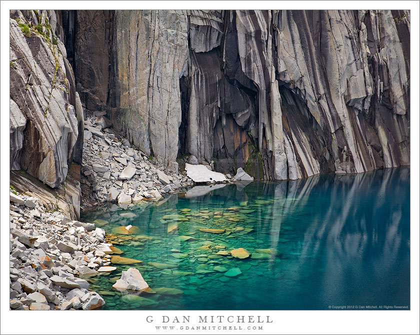
Submerged Boulders, Lake, and Cliffs
Sunlight illuminates submerged boulders near the cliff face along the High Sierra Trail – Sequioa National Park.

Submerged Boulders, Lake, and Cliffs. Sequoia National Park, California. August 6, 2008. © Copyright G Dan Mitchell – all rights reserved.

I have backpacked in California’s Sierra Nevada range for quite a few decades. A number (a large number!) of years ago my wife and I went on a two-week trans-Sierra backpack trip that traversed the range from west to east between Crescent Meadow and Whitney Portal,  following a route known as the “High Sierra Trail.” On the third morning we left our camp and began the stiff ascent toward the pass we had to cross to enter the Kern River drainage. Near the top of the steepest part of the climb the trail momentarily leveled out and we found ourselves facing a high, rockbound lake with a perfectly vertical patterned rock face dropping straight into the water on the far side. The view seemed familiar – and I realized that it was a scene captured by Ansel Adams (“Frozen Lake and Cliffs“) in the early 1930s.  (I also later realized that there is a wonderful and well-known photograph of the subject by Vern Clevenger.)

My wife and I were enthusiastic about photography in those days, too, and we carried a couple of Pentax SLRs and a few lenses and many rolls of film into the back-country. But I don’t think I came back with more than a few “snapshots” of this lake on that trip.

Fast-forward a few decades to 2008 when a group of my backpacking friends decided to follow this same trans-Sierra route — and, of course, I had to join them. Once again, I found myself ascending the trail toward that small bowl, but this time I had a plan to photograph the lake and the equipment to do it right. I recalled parts of the climb from my previous trip, but I had probably forgotten more than I remembered during the intervening decades. As the trail traverses a beautiful wet section full of wildflowers (which I had forgotten) I could tell that the lake was just ahead, and soon I topped a small saddle and saw the familiar scene before me.

As planned, I set to work doing some of the photography that I had contemplated before the trip. To be honest, I mainly worked from more or less the location that Adams must have used, though the conditions were a bit different on this day – the light was changeable as broken clouds passed above, and there was very little snow, much less ice, left at the lake. After perhaps 30 or 45 minutes of work, my hiking partners were getting restless and it was time to move on. I felt that I had worked this scene about as much as possible under the circumstances – and I did get a photograph of the “classic view” that I like a great deal — so I loaded up my heavy 9-day backpack load, put away the camera, and strapped the tripod to the outside of the pack. I hoisted the load and slowly started up the switchbacks immediately above the lake.

A couple of switchbacks up the trail I happened to look back at the lake from a slightly higher vantage point, and from here the astonishing deep blue color of the lake and the apron of rocks falling into the water became visible. My first reaction was a combination of “Wow!” and “No way am I taking this pack off and setting all that stuff up again!” Continue reading A Photograph Exposed: “Submerged Boulders, Lake, and Cliffs”