
Tag Archives: golden

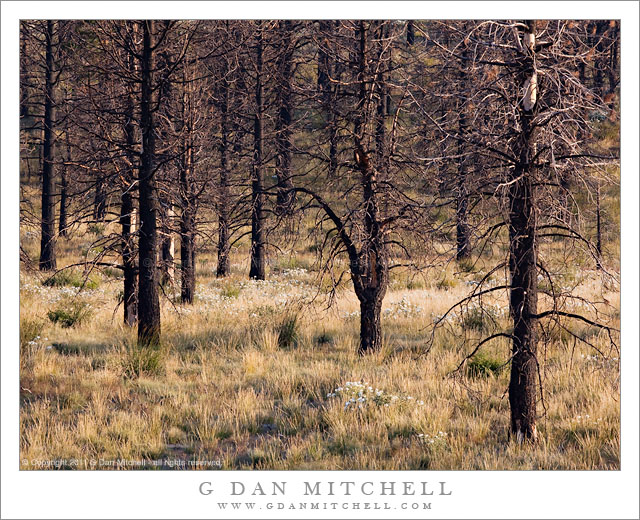
Burned Forest, Evening

Burned Forest, Evening

Burned Forest, Evening. Eastern Sierra Nevada, California. August 20, 2011. © Copyright 2011 G Dan Mitchell – all rights reserved.

Evening light on an eastern Sierra Nevada forest recovering from a recent wildfire.

This spot is in Mono County along highway 395 not far from June Lake, and it is a spot that I’ve had my eyes on for some time. As a person who was brought up in the “Smokey the Bear” era, when wildfires were thought to be entirely a bad thing, it took me a while to come to terms with the knowledge that such fires are a natural and necessary element. I understood this logically before I understood it aesthetically, and I struggled for some time with the idea that places where fires have occurred can be seen as sites of rebirth rather than as destruction and desolation.

I’ve been waiting for the right opportunity and the right light to photograph this burn area for a couple of years now. I pass by fairly often, but it has always been at the wrong time of day or at a time when I could not afford to stop. However, as is often the, unexpected coincidences caused me to be here just before sunset as the light turned golden in mid-August. Ironically, part of the cause was… a forest fire in Yosemite! Up in the Tuolumne area, the afternoon air had turned smokey and the light had taken on the sort of brownish color that forest fire smoke can create. This light was not inspiring me, so I thought that I’d drive over the pass and head south a short distance on highway 395 to see if I could find more interesting lighting. As I traveled south from Lee Vining I happened to notice the turn-off for West Portal Road, which heads out in the general direction of Mono Craters. I took this road and spent some time poking around, eventually making a few exposures in the area called Aeolian Buttes, and then returned to the main highway a bit south of where I had originally left the road.

As it happened, this choice dropped me onto 395 at a place where I could see this burned area just a bit further down the road. The sun was not far from dropping behind the Sierra crest, so I figured this could be my chance to give it a try. I found a spot where the late afternoon light was warming the color of the summer-dried grasses and some white flowers grew among the burned trees, and I had perhaps 15 minutes to work before the sun dropped behind the peaks.

G Dan Mitchell Photography
About | Flickr | Twitter | FacebookGoogle+ | 500px.com | LinkedIn | Email

Text, photographs, and other media are © Copyright G Dan Mitchell (or others when indicated) and are not in the public domain and may not be used on websites, blogs, or in other media without advance permission from G Dan Mitchell.

(Basic EXIF data may be available by “mousing over” large images in posts. Leave a comment if you want to know more.)
Morning, San Francisco Bay

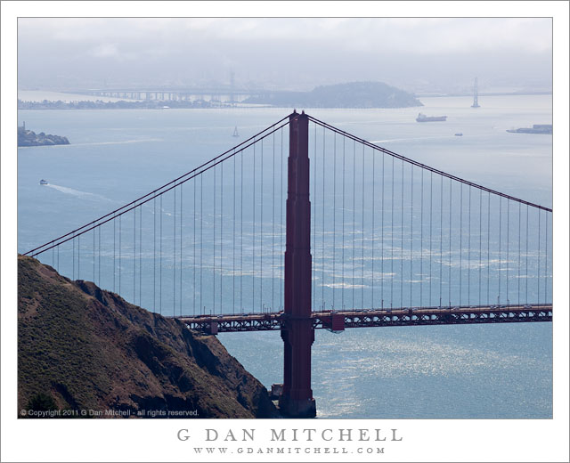
Morning, San Francisco Bay

Morning, San Francisco Bay. San Francisco, California. July 14, 2011. © Copyright 2011 G Dan Mitchell – all rights reserved.

Morning fog covers Oakland and the East Bay Hills as hazy sun illuminates sailboats and ships on San Francisco Bay beyond the Golden Gate Bridge.

This photograph was made from high in the Marin Headlands, after hiking up to the hill above Battery 129 near the high point on Conzelman Road, the scenic route that climbs this ridge above the Golden Gate. I had earlier shot a similar scene from a spot just a bit lower, but by now the morning fog and haze was clearing enough to allow a bit more sun to light up the waters of the Bay and to reveal a subtle blue color. (Later the blue would be much deeper, and earlier it had been nearly gray.) This particular shade of blue is one of the things I liked about this scene on this particular day.

The hill at lower left is part of the Marin Headlands and drops from the road almost straight down to the water. The small bit of land intruding into the frame on the left just above the wake of a boat is Alcatraz Island. Beyond that is Treasure Island and its companion, Yerba Buena Island. The latter is crossed by the San Francisco Oakland Bay Bridge, leading to Oakland which is just barely visible under the fog over the East Bay hills. Near the upper right is a tiny bit of one of the piers along the San Francisco waterfront.

G Dan Mitchell Photography
About | Flickr | Twitter | FacebookGoogle+ | 500px.com | LinkedIn | Email

Text, photographs, and other media are © Copyright G Dan Mitchell (or others when indicated) and are not in the public domain and may not be used on websites, blogs, or in other media without advance permission from G Dan Mitchell.

(Basic EXIF data may be available by “mousing over” large images in posts. Leave a comment if you want to know more.)
Rusted Gate and Concrete Wall, Battery 129

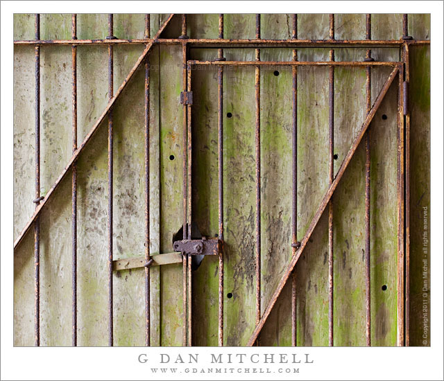
Rusted Gate and Concrete Wall, Battery 129

Rusted Gate and Concrete Wall, Battery 129. Golden Gate National Recreation Area, California. July 14, 2011. © Copyright 2011 G Dan Mitchell – all rights reserved.

Rusted gate against a weathered concrete wall at the entrance to a tunnel at Battery 129, Golden Gate National Recreation Area.

At the north end of the Golden Gate Bridge, Conzelman Road leads up into the Marin Headlands along the San Francisco Bay side of the ridge. This road is a favorite place for overlooking the Golden Gate and its famous bridge along with a large expanse of San Francisco and its Bay and points east. In mid-July the road was not accessible from the usual spot near the end of the bridge, so I detoured around towards the “back entrance” via the road to Rodeo Beach. From this road I turned up into the hills and joined Conzelman near its summit. I made a few foggy photographs of the Bay, but my main interest was in trying to find photographs in the old batteries and other abandoned military facilities along the ridge running out toward Point Bonita.

At the summit of the hill, before the road becomes very narrow and many people turn back, is “Battery 129.” There are several tunnels into this facility from alongside the road and a separate route leads up the hill to the old structures on the summit. I took one of the two tunnels under the hill and as I entered the second section I saw this old metal gate against a weathered concrete wall, illuminated by light leaking in from the end of the tunnel.

G Dan Mitchell Photography
About | Flickr | Twitter | FacebookGoogle+ | 500px.com | LinkedIn | Email

Text, photographs, and other media are © Copyright G Dan Mitchell (or others when indicated) and are not in the public domain and may not be used on websites, blogs, or in other media without advance permission from G Dan Mitchell.

(Basic EXIF data may be available by “mousing over” large images in posts. Leave a comment if you want to know more.)
Offshore Fog Bank, Marin Headlands

Offshore Fog Bank, Marin Headlands

Offshore Fog Bank, Marin Headlands. Golden Gate National Recreation Area, California. July 14, 2011. © Copyright 2011 G Dan Mitchell – all rights reserved.

Offshore fog lies beyond Point Bonita and Rodeo Beach and the Marin Headlands of the Golden Gate National Recreation Area.

I was surprised to find a clear view like this during my mid-July visit to the Marin Headlands of the Golden Gate National Recreation Area (GGNRA) across the Bay from San Francisco. I had almost decided to stay home or go elsewhere based on weather reports that had the coast completely socked in my dense fog for most of the day. Indeed, it was foggy as I passed through San Francisco and drove across the Golden Gate Bridge. The fog was high, and I could see some distance beneath it, but it was still a rather gray day.

Since the lower section of Conzelman Road, the normal quick and scenic route up into the headlands, was closed for construction, I took that alternate route that passes through a tunnel to come out near Rodeo Beach. I turned left up the hill to reach the upper section of the road. After photographing near Battery 129 for a while, the sun began to break through the fog, and I was surprised to find a fairly clear patch just outside the Golden Gate.

The photograph shows the last section of the headlands as the hills drop towards the historic fort and batteries near the Point Bonito light house, which is barely visible at the end of the peninsula on the left. The line of surf at the upper right is Rodeo Beach, a popular spot with Bay Area folks.

G Dan Mitchell Photography
About | Flickr | Twitter | FacebookGoogle+ | 500px.com | LinkedIn | Email

Text, photographs, and other media are © Copyright G Dan Mitchell (or others when indicated) and are not in the public domain and may not be used on websites, blogs, or in other media without advance permission from G Dan Mitchell.

(Basic EXIF data may be available by “mousing over” large images in posts. Leave a comment if you want to know more.)