
Tag Archives: island

Winter Fog, Water, Island

Winter Fog, Water, Island
Winter fog obscures the view of a wetland island

Winter Fog, Water, Island. Central Valley, California. February 15, 2016. © Copyright 2016 G Dan Mitchell – all rights reserved.

Winter fog obscures the view of a wetland island

This is one of a pair of similar photographs I made in this spot on a lovely dense fog morning out in the winter Central Valley. (The other is simpler and doesn’t include the foreground plants.) We had arrived quite a bit earlier and had already done a circuit of the gravel road that encircles the location, and we were now on our second loop. Believe it or not, the fog had become a lot less thick by the time I made the photograph!

Imagine that everything is still, but that the sounds of birds are everywhere — a combination of visual stillness but audio tumult in every direction. As I watched this little island the fog continued to thin and thicken, and at times it almost became invisible. Shortly after I made the photograph the clearing began in earnest and the beaks began to develop in the shallow tule fog.


G Dan Mitchell is a California photographer and visual opportunist. His book, “California’s Fall Color: A Photographer’s Guide to Autumn in the Sierra” is available from Heyday Books and Amazon.
Blog | About | Flickr | Twitter | Facebook | Google+ | 500px.com | LinkedIn | Email


All media © Copyright G Dan Mitchell and others as indicated. Any use requires advance permission from G Dan Mitchell.

Storm, Mono Lake

Storm, Mono Lake
Dark clouds of a massive summer thunderstorm move across Mono Lake.

Storm, Mono Lake. Eastern Sierra Nevada, California. August 7, 2015. © Copyright 2015 G Dan Mitchell – all rights reserved.

Dark clouds of a massive summer thunderstorm move across Mono Lake.

This has been the “summer of the monsoon” in the Sierra Nevada. Although the range is terribly dry after four years of drought and this past winter’s truly anemic snow pack, summer has brought a greater than usual amount of monsoonal flow from the south, producing a great deal of thunderstorms and rain. In July I saw an odd juxtaposition of nearly snow free peaks and ridges that looked like late September of a dry year… along with green meadows and full ponds where the rains had fallen.

By the time of this early August visit to the Yosemite High Sierra and then a few days of backpacking on the east side of the range further south, things were drying out a bit and the foliage was taking on the usual late-August dry appearance. I camped down in Lee Vining Canyon the first night, and being close to Mono Lake I managed to head out there and make photographs after setting up camp. Thunderstorms were forming above the Sierra crest, and they had sprinkled on my camp. They then drifted east of the range and continued to build, so as I looked along this section of the north shore of Mono Lake, with Black Point and Negit Island visible in the foreground, the sky in the distance was turbulent, dark, and full of falling rain.


G Dan Mitchell is a California photographer and visual opportunist. His book, “California’s Fall Color: A Photographer’s Guide to Autumn in the Sierra” is available from Heyday Books and Amazon.
Blog | About | Flickr | Twitter | Facebook | Google+ | 500px.com | LinkedIn | Email


All media © Copyright G Dan Mitchell and others as indicated. Any use requires advance permission from G Dan Mitchell.

Island and Trees, Tuolumne River

Island and Trees, Tuolumne River
“Island and Trees, Tuolumne River” — Trees grow on a small ,rocky island in the Tuolumne River, Yosemite National Park

This first evening on a recent trip to the Yosemite high country turned out to be special. I arrived in the park in the middle of the day and snagged a camp site at Tuolumne Meadows. I set up my simple camp, lounged around a bit, and then it was time to head out and look for photographs. I headed back along Tioga Pass Road, making note of several possibilities as I passed the meadow, then turned around to go back to one of them. Along the way I decided to pull over to take in the view and by lucky coincidence I pulled in right behind my friends Michael and Claudia. We ended up hiking across the meadow to a likely photography location. Within moments a couple caught up with us — another group of friends, Charlotte and Gary!

Our group continued hiking along the river, eventually reaching a beautiful area where the slope increased, the channel narrowed, and the river picked up speed. Here it glides across granite slabs, bounces around and across boulders, and occasionally pools for a moment in hollows in the valley. We stopped at a granite bowl where the river makes a bend, and I photographed this small island and its trees against a background of late-afternoon sky with dissipating clouds.


G Dan Mitchell is a California photographer and visual opportunist. His book, “California’s Fall Color: A Photographer’s Guide to Autumn in the Sierra” (Heyday Books) is available directly from him.

G Dan Mitchell: Blog | Bluesky | Mastodon | Substack Notes | Flickr | Email


All media © Copyright G Dan Mitchell and others as indicated. Any use requires advance permission from G Dan Mitchell.
Whalers Cove

Whalers Cove
Whalers Cove

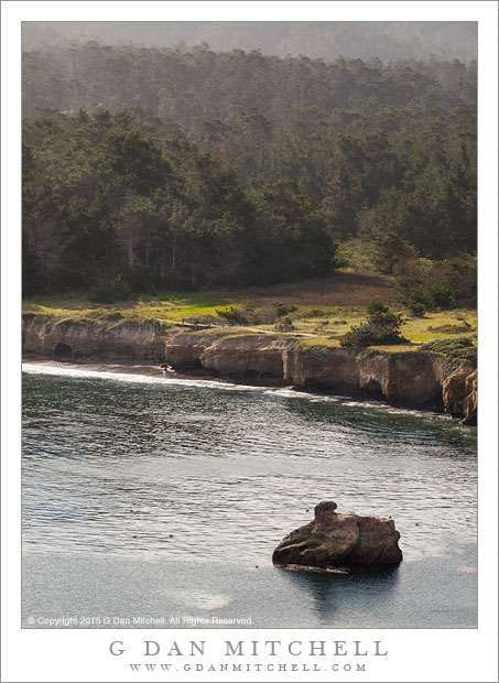
Whalers Cove. Point Lobos, California. March 15, 2015. © Copyright 2015 G Dan Mitchell – all rights reserved.

Whalers Cove at the Point Lobos State Reserve

People who head straight toward the ocean at Point Lobos, driving west through the park and then south, probably miss this spot completely since it is off to the side and down a hill a bit. It is very popular with divers and recently I’ve seen kayakers working out of the cove. It is also a good place to find various sorts of birds — on more than one occasion I’ve photographed egrets standing on seaweed and hunting for meal.

This time I hiked up the trail that climbs away from the cove and towards the north shore of the park with its cypresses and steep cliffs dropping to the water. From the early part of the climb I could look back over the cove and see the small meadow at its head and the layers of forest and hills beyond as they rise toward the ring of the coastal hills across and beyond the Pacific Coast Highway.


G Dan Mitchell is a California photographer and visual opportunist whose subjects include the Pacific coast, redwood forests, central California oak/grasslands, the Sierra Nevada, California deserts, urban landscapes, night photography, and more.
Blog | About | Flickr | Twitter | Facebook | Google+ | 500px.com | LinkedIn | Email

Text, photographs, and other media are © Copyright G Dan Mitchell (or others when indicated) and are not in the public domain and may not be used on websites, blogs, or in other media without advance permission from G Dan Mitchell.