Tag Archives: june

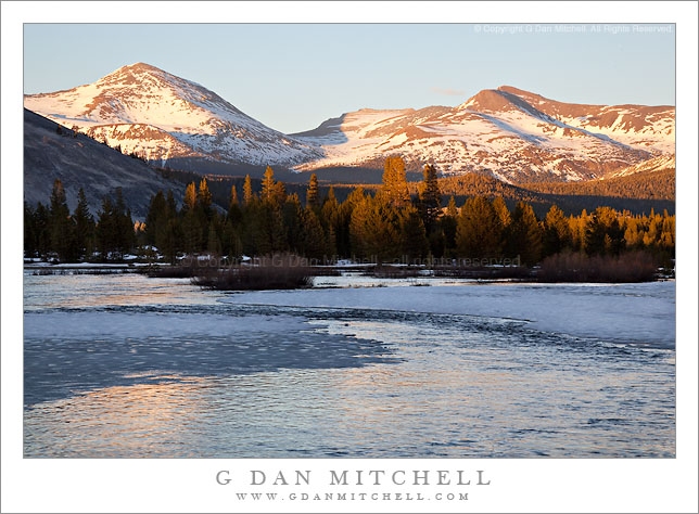
Flooded Tuolumne Meadow, Mounts Dana and Gibbs, Evening

Flooded Tuolumne Meadow, Mounts Dana and Gibbs, Evening

Flooded Tuolumne Meadow, Mounts Dana and Gibbs, Evening. Yosemite National Park, California. June 5, 2010. © Copyright G Dan Mitchell – all rights reserved.

Evening light on snow-covered Mounts Dana and Gibbs reflected on the surface of the flooding Tuolumne River, Tuolumne Meadows.

Tioga Pass opened this year on June 5, a bit later than usual. The late opening was due to a slightly greater than average amount of precipitation this past winter and a cold and wet May. As a consequence, there was a lot of snow on opening day, and lots and lots of run-off water.

I made this photograph in the evening in Tuolumne Meadows as the late light was just leaving the tops of the trees below Lembert Dome and beginning to color the summits of Mounts Dana and Gibbs with warm “golden hour” light. The Tuolumne River was so full that it had flooded large sections of the meadow – parts looked more like “Tuolumne Lake” than Tuolumne Meadow. Because the meadow was still covered with snow, the surface of the flooded areas was full of ice and slush. The overall appearance was closer to that of a winter scene, even though the calendar said early June.

G Dan Mitchell Photography
About | Flickr | Twitter | Facebook | Google+ | 500px.com | LinkedIn | Email

Text, photographs, and other media are © Copyright G Dan Mitchell (or others when indicated) and are not in the public domain and may not be used on websites, blogs, or in other media without advance permission from G Dan Mitchell.

(Basic EXIF data may be available by “mousing over” large images in posts. Leave a comment if you want to know more.)


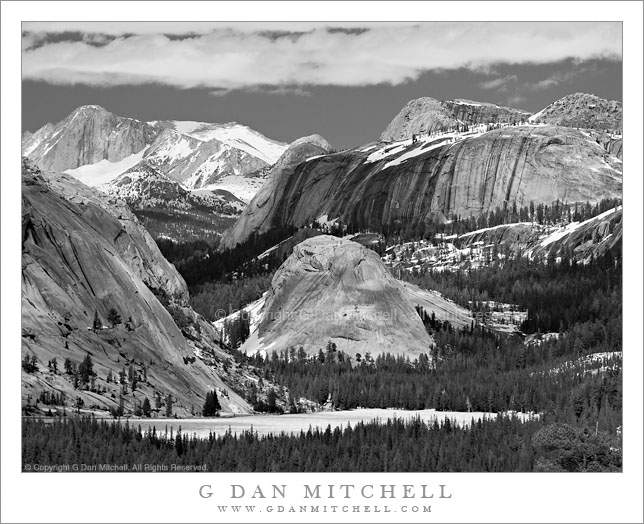
Early Season Ice on Tenaya Lake

Early Season Ice on Tenaya Lake

Early Season Ice on Tenaya Lake. Yosemite National Park, California. June 5, 2010. © Copyright G Dan Mitchell – all rights reserved.

Black and white photograph of early season ice on the surface of Tenaya Lake with high granite peaks and domes beyond, Yosemite National Park, California.

A long-lens version of the classic view of Tenaya Lake from Olmsted Point, made on the day that Tioga Pass Road opened for the season and while ice still covered almost all of the surface of the lake. Peaks and domes tower above the lake, including the heights of Mount Conness near the upper left. In a larger version of this photograph, many seasonal waterfalls are visible along the sides of the cliffs and domes.

This photograph is not in the public domain and may not be used on websites, blogs, or in other media without advance permission from G Dan Mitchell.

G Dan Mitchell Photography | Twitter | Friendfeed | Facebook | Facebook Fan Page | Email

Technical Data:
Canon EOS 5D Mark II
Canon EF 100-400mm f/4.5-5.6 L IS USM at 210mm
ISO 200, f/5.1, 1/400 second

keywords: yosemite, national, park, sierra, nevada, mountain, spring, nature, california, usa, north america, tenaya, lake, dome, conness, peak, ridge, snow, ice, field, forest, granite, cliff, june, olmsted, point, landscape, nature, cloud, sky, black and white, monochrome, tioga, pass, road, highway, 120, trans, scenic, travel, stock

Ice and Snow on Tioga Pass and Tioga Lake

Ice and Snow on Tioga Pass and Tioga Lake

Ice and Snow on Tioga Pass and Tioga Lake. Near Yosemite National Park, California. June 5, 2010. © Copyright G Dan Mitchell – all rights reserved.

Late afternoon shadows fall across the frozen surface of Tioga Lake with Tioga Pass and the snow-covered peaks of Kuna Crest beyond.

On June 5 I made my first “summer season” visit to the Sierra of the year. Usually I mark the start of the post-winter part of the year by heading to Yosemite Valley to experience the waterfalls close up during the peak flow of the meltwater-filled rivers. This year I had time for a one-day trip and I did, indeed, start in the Valley. The waterfalls are close to as big as they get right now, and the Merced River is close to reaching flood stage, with large meadow areas of the Valley already under water. (The latter is actually a normal condition at the peak of the runoff cycle.) However, after shooting in the Valley into mid-morning, I decided to head elsewhere because the crowds were oppressive and because tran-Sierra Tioga Pass Road had opened this very morning.

I’ve been over Tioga Pass Road before on or close to the first day that the route is open, but I haven’t seen conditions like these up there since the mid-1990s. (In 1996, IIRC, the pass didn’t open until July 1 after a very heavy and late winter.) There was still snow almost everywhere along the road. It would be possible to ski or snow-shoe in many areas and, in fact, there were people engaged in just those activities. Melting water was everywhere. In places where I have never seen water before there were roaring creeks, often pouring down next to or even onto the roadway. All lakes and ponds are nearly or completely frozen still. Tuolumne Meadows itself is still completely covered by snow… except where the flooding Tuolumne River has created a giant, fast-moving lake.

I made this photograph at Tioga Lake late in the afternoon after making a traditional visit to the “Who Nellie Deli” in Lee Vining for the ritual fish tacos. Long shadows from nearby peaks and clouds fall across the frozen surface of the lake, the saddle of Tioga Pass is beyond, and in the farthest distance it is still winter on the peaks of Kuna Crest.

This photograph is not in the public domain and may not be used on websites, blogs, or in other media without advance permission from G Dan Mitchell.
G Dan Mitchell Photography | Twitter | Friendfeed | Facebook | Facebook Fan Page | Email

Technical Data:
Canon EOS 5D Mark II
Canon EF 24-105mm f/4 L IS USM at 90mm
ISO 200, f/9, 1/1000 second

keywords: yosemite, national, park, sierra, nevada, mountain, spring, nature, tioga, lake, pass, mammoth, peak, kuna, crest, ridge, winter, conditions, spring, early, season, june, 2010, snow, ice, frozen, shadow, rock, boulder, reflection, melt, forest, sky, cloud, evening, road, eastern, landscape, winter, nature, stock

Clearing Storm, Carson Peak and Grant Lake

Clearning Storm, Carson Peak and Grant Lake

Clearing Storm, Carson Peak and Grant Lake. June Lakes Loop, California. June 7, 2009. © Copyright G Dan Mitchell – all rights reserved.

A late spring storm clears from the summit of Carson Peak above Grant Lake along the June Lakes Loop, California.

I’ll start by saying that I hope I have identified this peak correctly. I did not know its name when I made the photograph, and I think I’ve lined it up with the other geographic features on my map correctly – but if any one has a different ID on this peak please let me know.

I came to Grant Lake (which is actually, and obviously, a reservoir) from the back route, arriving by way of some dirt roads coming in from highway 395. I arrived at the dam and followed the road across, stopping in the middle to make some photographs when I saw this late light on the lake and shoreline with the peak gradually emerging from the remnants of this late-spring storm.

This photograph is not in the public domain. It may not be used on websites, blogs, or in any other media without explicit advance permission from G Dan Mitchell.

keywords: late, spring, storm, clears, clearing, carson, peak, grant, lake, june, lakes, loop, road, reservoir, rock, peninsula, low, water, surface, boulder, sun, light, evening, eastern, sierra, nevada, mountain, range, ridge, shadow, tree, forest, rock, valley, tower, cloud, blue, sky, landscape, travel, scenic, stock