Tag Archives: lakes

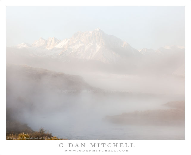
Morning Fog on Hot Creek, Mount Morrison

Morning Fog on Hot Creek, Mount Morrison

Morning Fog on Hot Creek, Mount Morrison. Owens Valley, California. October 9, 2010. © Copyright G Dan Mitchell – all rights reserved.

Morning fog rises above Hot Creek with the Sierra crest and Mount Morrison in the distance.

Finding this shot was just about as random a process as I can imagine. I was in the eastern Sierra to photograph aspens, and staying in Mammoth Lakes. I woke up very early without a really solid idea of where I’d shoot that morning, but started out heading for Rock Creek, where I had seen great aspen color a week earlier. As I left Mammoth and headed south on highway 395 I noticed low fog out in Owens Valley – Crowley Lake was pretty much covered and it appeared that there were bits of fog here and there above creeks and springs in the valley. This started to look more interesting to me than photographing aspens again, so I changed plans and headed out into Owens Valley, not knowing precisely where or what I might find but thinking it would involve fog and mist and early morning light.

I first stopped and photographed near a small pond along side the road. After shooting here a bit – mostly shots pointing back toward the Sierra crest – I recalled that I had been on some gravel roads a bit further north of my position, and I decided to do a bit of exploring. I turned off on the first road going north and followed it until I found another interesting road that dropped down into a small valley and crossed a creek on an old rickety bridge – I later figured out that this was Hot Creek. A cloud of mist and fog was lying above the path of the creek, periodically thickening and thinning, and because it was not deep the morning sun was still somewhat lighting the scene through the fog. At times the peaks of the Sierra crest would gradually resolve through the fog. I set up and waited and made some exposures as the fog rose and fell, increased and decreased.

This photograph is not in the public domain and may not be used on websites, blogs, or in other media without advance permission from G Dan Mitchell.

G Dan Mitchell Photography | Twitter | Friendfeed | Facebook | Facebook Fan Page | Email

Kearsarge Pinnacles

Kearsarge Pinnacles
Kearsarge Pinnacles

Kearsarge Pinnacles. Kings Canyon National Park, California. July 30, 2010. © Copyright G Dan Mitchell – all rights reserved.

Late afternoon like on alpine lakes, meadows, and forest below Kearsarge Pinnacles, Kings Canyon National Park.

Kearsarge Pinnacles shares its name with (Kearsarge) lakes and a (Kearsarge) pass just to the west of the Onion Valley trailhead. This is not exactly an untraveled spot in the Sierra, given that it is merely one day in on a reasonable (by east side standards) pass and that it provides access to some very popular areas of the Kings Canyon back-country and to the John Muir Trail.

I’ve been over this pass a number of times. I’ve come in this way to start trips north over Baxter Pass and south into the upper Kern River basin and over Mt. Whitney. I exited here some years back on the ninth day of a trip that started at Bishop Pass and crossed a series of JMT high passes including (in addition to Bishop) Mather, Pinchot, and Glenn passes.

Here late afternoon light, filtered by clouds, illuminates the granite benches and scattered trees above a couple of the upper lakes in the basin. Despite the obvious impressive beauty of this location, I find that it presents some photographic challenges, at least when I try to photograph “grand views” of the area and the surrounding landscape. One of them, at least in my experience, is that the light angles can be a bit tricky. For example, as the sun sets it isn’t quite far enough north to light up the slopes of the pinnacles, and some of the interesting foreground subjects go into shadow as the light warms up. On this evening I made one of those timing discoveries that I’ll have to remember and apply the next time I’m there – from about the location of this photograph there was a minute or two of very interesting light right on the upper edges of the closer ridges… which I wasn’t quite quick enough to capture!

This photograph is not in the public domain and may not be used on websites, blogs, or in other media without advance permission from G Dan Mitchell.

G Dan Mitchell Photography | Twitter | Friendfeed | Facebook | Facebook Fan Page | Email
Winter arrives in the Sierra?

A few years ago I did what was a traditional end-of-season backpack trip out of Tuolumne Meadows on the last weekend during which the NPS permits overnight parking on Tioga Pass road – this is typically on or just before October 15. It was a beautiful weekend with – as I always hope for in October – pleasant, sunny conditions and beautiful light.

The following weekend a backpacking buddy who had been unable to make that trip tried his own end-of-seasons visit, hoping to wander up into the Twenty Lakes Basin area just east of Tioga Pass. He arrived late and rolled out his bivy sack at the small campground by the lake right below Tioga Pass… and woke up the next morning with more than a half foot of snow on top of him and more on the way. He scrambled out of his bag, got into his car, and managed to get out just before the road was blocked. He liked to say that he was there for the switch from fall to winter… literally.

It sounds like something similar may happen over the next 24 hours. From all reports, one of the biggest October storms that we’ve seen in California in decades may be sweeping through tonight and tomorrow, bringing heavy winds, a lot of rain, and the potential for some significant snow at the higher elevations.

The folks at the Dweeb Report (interesting source of Sierra weather info) include an ominous sentence in their most recent update: “WINDS WITH THIS SYSTEM OVER THE CREST COULD REACH BETWEEN 120MPH AND 140MPH OVER THE CENTRAL SIERRA.”

Of course, you knew this was leading to a comment on aspens, right? Given the rather strange conditions for aspen color this fall, somehow it doesn’t seem at all surprising that the storm might bring down a good portion of the remaining leaves!

A Brief Aspen Update (9/28/09)

Although my main weekend photographic activity involved a short pack trip into the Cathedral Lakes in Yosemite (more later on that), I did manage a quick Sunday afternoon visit to some aspens in the Tioga Pass, Lee Vining, Conway Summit area. With that in mind, here is a short report on what I saw.

  • Tioga Pass – As you head east over Tioga Pass you begin to enter the “aspen zone” of the eastern Sierra. (There are aspens west of the crest, but very few in this area and fewer still along the road.) There are some specimens turning colors in roughly the Ellery Lake area, but the first really colorful trees are near the far end of the section of the road the traverses the headwall of Lee Vining Canyon. These are small trees, but some are quite colorful right now – with other still-green trees promising a bit more color yet to come. From this area I could also see more aspens (and other fall foliage) on higher ridges above the canyon.
  • Lee Vining Canyon – A bit later the large aspen groves down in Lee Vining Canyon will usually put on quite a show – and many of the trees growing in this lower elevation protected area are quite large. However, yesterday there was very little color down in the canyon. I could see a very few trees starting to turn, but that was about it.
  • Lundy Canyon – I did not enter Lundy Canyon on this trip since I had another goal in mind – so what I can report is based entirely on what I could see while driving by on highway 395. High on the ridges above Lundy Canyon there are some very colorful groves of trees. There appeared to also be some down closer to the entrance of the canyon. (I’ll post more concrete information about Lundy as soon as I can find it. Typically Lundy Canyon peaks a bit later than some of the other areas.)
  • Conway Summit – The huge groves of aspens right below the highway to the north of Conway Summit are barely starting to turn colors. I saw a very small number of yellow trees right near the road but the vast majority of the trees here still appear to be green. This bodes well for conditions in a week or so. However, the long view toward Dunderberg Meadow from here shows that the higher trees are changing and colors there may be peaking. (I could not investigate these upper groves more closely since the car I was driving is not equipped for travel on rough gravel roads.) South of Conway Summit there are some large and not very accessible groves that are turning colors quite dramatically, but it is next to impossible to find a place to pull over and photograph them.
  • Virginia Lake – The road to Virginia Lake leaves right from Conway Summit. Based on my visits in previous seasons, the trees along this road, especially up higher, tend to be among earliest to show color and then drop their leaves. I have arrived too late more than once! Yesterday, however, there were many trees showing very good color even along the upper sections of the road. There are also still a good number of green trees, so this show is probably not quite over. The first groves you come to shortly after leaving Conway Summit are currently at different stages of color. There is a parking area along the right side of the road in this area, and the trees parallel to the turnout on the right as you ascend are almost entirely green. However, across the road and just a bit further up there is a large and colorful grove where I photographed. Although there are still green trees here, there are also a few trees that have lost quite a few leaves. Another grove a bit higher alongside a creek at an obvious bend in the road is starting to look quite colorful, though the number of green trees suggests that there is still some good color to come.

UPDATE: For first time visitors to my site arriving via this page… I have posted several other notes on aspen hunting during the 2009 season:

Enjoy!