
Tag Archives: landscape

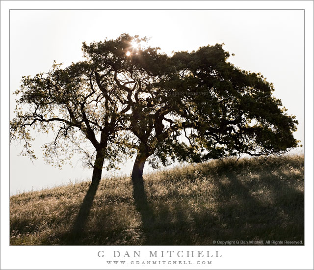
Two Oaks, Morning Sun

Two Oaks, Morning Sun

Two Oaks, Morning Sun. Calero Hills, California. April 30, 2011. © Copyright G Dan Mitchell – all rights reserved.

The springtime morning sun shines through a pair of oak trees in the Calero Hills south of San Jose, California.

On the final day of April and for the first time this season, I found to go for a hike at my favorite local park, a place where I have walked just about every available trail (and invented a few routes of my own) and photographed for a number of years. The park would not seem like anything all that special by comparison to some of the other places I visit, but it is close and I’ve gotten to know it in a way that makes it more special. The place is called the Calero County Park, part of the Santa Clara County Parks system.

The entrance to the park is in a broad valley that is largely occupied by stables. (Or, used to be – it looks like the stables must have closed since last season.) Rising from this valley are the typical grass-covered hills of central and northern California, with oaks and other trees scattered around and, in places, thicker trees and brush. At this time of year, the hills turn what I call “impossibly green” – and if you have seen them on a late-winter or early spring morning you know what I mean.

I started this hike a bit after dawn, so the golden hour light was more or less gone. I had a general idea of photographing some wildflowers (which didn’t happen – it was too windy) and some oak trees that grow alone or in small groups on the grass-covered hills. I passed a small lake – where a single egret often hangs out, but not on this morning – and topped a rise and descended into a small valley from which I have made quite a few photographs of oaks. It didn’t look too promising at first, but at the far end of this area I noticed that a pair of trees were still obscuring the sun and that I might be able to shoot straight into the sun with the trees blocking its disk, and get a photograph including the tree shadows on the hillside grasses.

This turned out to be another of those all-too-common ephemeral photographs in that the sun was starting to rise above the top branches of the tree and would soon be “out in the open,” making it much too bright for what I had in mind. So I worked quickly to set up tripod and camera and select a lens, then frame a composition, focus, and make a series of exposures that might be needed to deal with the huge dynamic range between direct sun and backlit tree trunks. By the time I had everything set up and was ready to shoot the sun had already risen above the upper branches, so I ended up looking for a slightly better shadow and putting the tripod down very low – and this gave me must enough time to make the series of exposures I figured I would need.

In the end, I got lucky. One single shot somehow managed to not blow the sun out too badly yet hold enough detail in the grass that a bit of work in post could bring it back. With all of the potential for lens flare – which I had to some extent in every shot – this one only had two small bits of it, and they were easily dealt with.

G Dan Mitchell Photography | Flickr | Twitter (follow me) | Facebook (“Like” my page) | LinkedIn | Email
Text, photographs, and other media are © Copyright G Dan Mitchell (or others when indicated) and are not in the public domain and may not be used on websites, blogs, or in other media without advance permission from G Dan Mitchell.
Abandoned Mining Cabin Ruins, Panamint Range

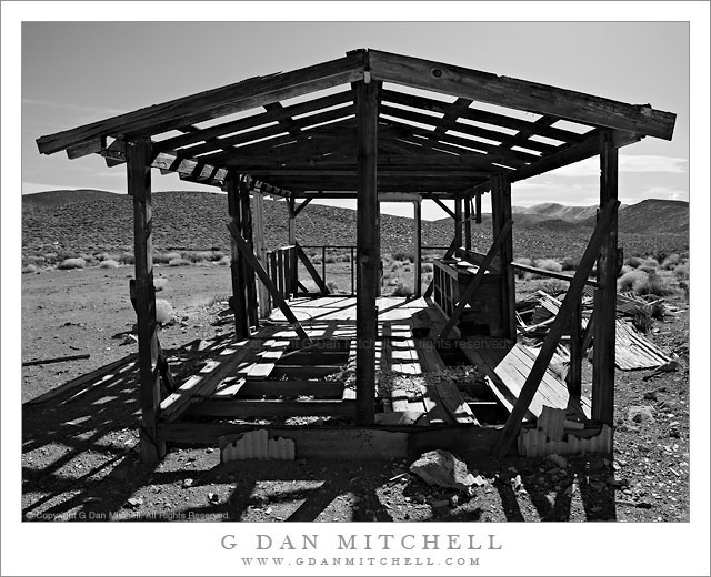
Abandoned Mining Cabin Ruins, Panamint Range

Abandoned Mining Cabin Ruins, Panamint Range. Death Valley National Park, California. March 29, 2011. © Copyright G Dan Mitchell – all rights reserved.

Black and white photograph of the ruins of an abandoned mining cabin high in the Panamint Mountain Range of Death Valley National Park.

There are a number of things that make Death Valley National Park, to the best of my knowledge, rather unique. One is the extensive history of human habitation inside the park boundaries, quite a bit of which is visible –  though some takes a bit more effort and attention to spot. The history of mining in the park is well-known, and many of the icons of the park have connections to this history. If you visit Furnace Creek, for example, you cannot miss the displays of old wagons and so forth used to move ore out of the Valley. It doesn’t take a lot of careful study to figure out that many park roads originated in an era of prospecting and mining. There are several well-known examples of structures left over from that era in and around the park, too.

It is largely because of this history that many areas of this national park are (or have been – some are now reverting to wilderness status) accessible by gravel road or four-wheel-drive routes. I would argue that you can’t really get to know this park if you just stick to the paved roads and the points of interest that they access. If you drive any of these other routes and keep your eyes open you will often be surprised by the left overs from relatively recent mining and prospecting, much of which isn’t really written about or described in the usual guides to the park. (And I’m not going to offer specific details about where to find such places here, since I don’t want to be even a little bit responsible for damage to them. If you do visit, treat them with care and respect.)

As I drove along a gravel road in one of the many mountain ranges of the park, returning from a site that is somewhat well-known, I began to notice evidence of fairly recent mining and prospecting. Faint tracks depart from the main “road” and cross valleys and hills, here and there tailing piles and mine entrances are visible, and sometimes you come across old structures such as cabins, storage bunkers, or wooden towers above mine entrances. I spotted the ruins of this old cabin above the road at one point and decided to walk up and investigate.

I’m almost always surprised at how “modern” many of the traces found at these places seem to be. I guess I am expecting something from the 1800s, but quite a few of these places look like they were build and occupied much later than that. I find modern things like linoleum flooring or modern-looking nails or electrical wire in many of them. There obviously isn’t much left of this cabin now, but from the detritus lying around near it and the form and materials found here, it must have been a reasonably comfortable place to live. As I walk around such places I often try to imagine what it must have been like to wake up every morning in this silent desert and head out for another day of physical labor.

G Dan Mitchell Photography | Flickr | Twitter (follow me) | Facebook (“Like” my page) | LinkedIn | Email
Text, photographs, and other media are © Copyright G Dan Mitchell (or others when indicated) and are not in the public domain and may not be used on websites, blogs, or in other media without advance permission from G Dan Mitchell.
Playa Surface, Panamint Valley

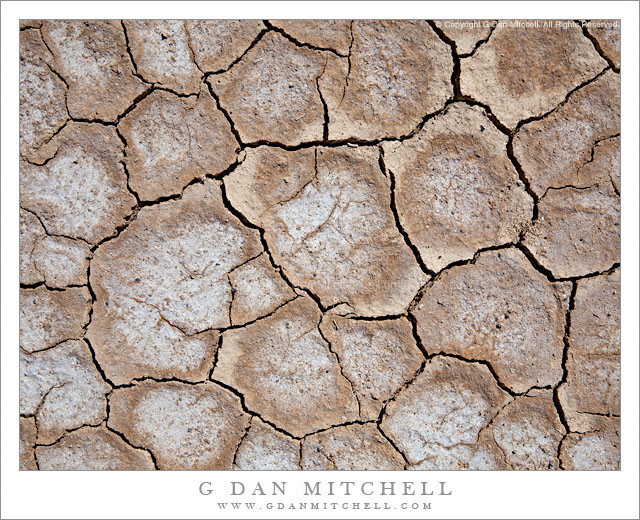
Playa Surface, Panamint Valley

Playa Surface, Panamint Valley. Death Valley National Park, California. March 31, 2011. © Copyright G Dan Mitchell – all rights reserved.

Cracked and dry surface of the playa in Panament Valley, Death Valley National Park.

This micro-scene could be found in many locations in Death Valley and, for that matter, in many places in the USA and around the rest of the planet. But my little rectangle of the patterns of drying and cracked mud comes from the surface of the Playa (sometimes called “Panamint Lake?”) in upper Panamint Valley in Death Valley National Park. I wrote previously that it was the last day of my late-March photographic visit to Death Valley – I had finished my photography in the main Valley and had started the long drive back to the Bay Area. After crossing Towne Pass the road descends into Panamint Valley to a junction where I most often go south towards Trona and Ridgecrest and beyond.

Just before this junction the road crosses the playa, an extraordinarily flat surface formed when silt washed down from the surrounding mountains occasionally pools and gradually dries, forming what may be the flattest surfaces on the planet. As the moisture evaporates the mud cracks and splits into these interesting semi-geometrical patterns.

For no particular reason other than that this is a spot where I often make one final stop before leaving the park, I pulled over and wandered out onto the playa. I enjoy walking on these often-immense flat surfaces, but there is something very odd about the experience, too. Perhaps it is the slightly odd feeling of walking on such a large floor-flat surface in the natural world, or it might be the deep silence and stillness. In any case, as I wandered around not too far from the road I started looking a bit more closely at the patterns of cracks and soon decided that my photography was not quite finished yet – so I went back to the car to get my camera and made a small series of hand-held photographs with the camera pointing straight down. (The “straight down” shooting raises a question: How should the photograph be oriented? The horizontal orientation shown here is what I saw as I made the photograph… but I also wonder about rotating it 90″ clockwise.)

G Dan Mitchell Photography | Flickr | Twitter (follow me) | Facebook (“Like” my page) | LinkedIn | Email
Text, photographs, and other media are © Copyright G Dan Mitchell (or others when indicated) and are not in the public domain and may not be used on websites, blogs, or in other media without advance permission from G Dan Mitchell.

Post-Sunset Glow, Amargosa Range

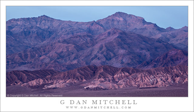
Post-Sunset Glow, Amargosa Range

Post-Sunset Glow, Amargosa Range. Death Valley National Park, California. March 29, 2011. © Copyright G Dan Mitchell – all rights reserved.

Post-sunset light from bright red clouds casts a reddish glow on the Amargosa Range, Death Valley Buttes, and the Kit Fox Hills.

I think this might be the second in what I could call the “impossible color” series from my late-March trip to Death Valley. (The previous image was a photograph of a wash/alluvial fan at the base of Tucki Mountain, photographed on the same evening.) The lurid and unreal colors are not the result of post-processing gone horribly wrong – the light was actually this color for a short period. The sun had already gone down behind the Cottonwood Mountains to the west of my shooting location in the middle of Death Valley not far from Stovepipe Wells. It had been an interesting sunset with the usual increase in warm colors and some attractive clouds in the sky.

What happened next was something that is probably familiar to those who have done a lot of landscape photography, though they recognize that it is not something that you can quite predict. After the sun had set and dusk was coming on, some final light from far to the west, where the sun had probably already dropped just below the horizon, began to strike high clouds above Death Valley. (I could sort of see this coming, since I had noticed increasing color in the sky further to the east.) As this happened, these clouds began to glow with an intense red color that was mixed with the normal bluish tones of dusk light and surface features took on this purple/red glow for just a brief moment before the light faded.

(Those who look very carefully may notice that the sky above and to the east of the mountains is a lot bluer than the mountains themselves. The color had already left the sky to the east, and at this point was coming from the sky directly overhead and to my west.)

I’m still trying to sort out the complex geology of this area and the ways that features are named. The larger range containing these peaks is called the Amargosa Range, though it encompasses many smaller named sub-ranges – I think these might be part of the Grapevine Mountains, roughly in the neighborhood of Thimble and Corkscrew Peaks. A dark peak in front of the main range at the very far right may be part of Death Valley Buttes, and the banded foreground hills are sometimes called the “Kit Fox Hills.”

G Dan Mitchell Photography | Flickr | Twitter | Facebook |
LinkedIn | Email
Text, photographs, and other media are © Copyright G Dan Mitchell (or others when indicated) and are not in the public domain and may not be used on websites, blogs, or in other media without advance permission from G Dan Mitchell.