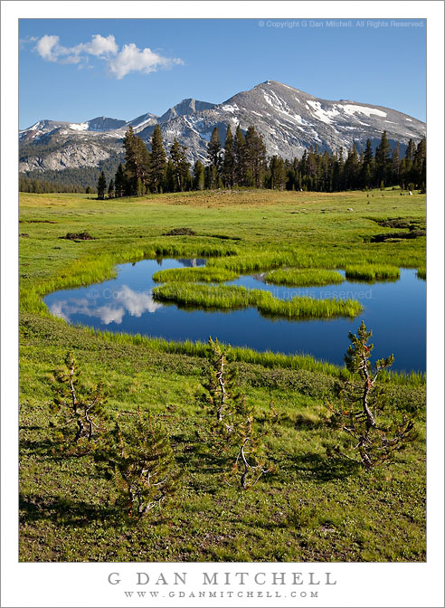
Young lodgpole pines grow in front of a Dana Meadows pond as Mammoth Peak looms in the distance.
Late in July of this somewhat wet year, the portion of Dana Meadows that extends almost up to the top of Tioga Pass was still very green and a bit wet, with small streams flowing through it and seasonal tarns still full. Being careful to avoid the boggy spots, I wandered down in to this section of the meadow near where the old roadbed is still visible and found small ponds and young trees trying to infiltrate the meadow. Here the pond reflects clouds floating towards Mammoth Peak, the high point at the end of Kuna Crest, on the other side of which is found the Lyell fork of the Tuolumne River.
This photograph is not in the public domain and may not be used on websites, blogs, or in other media without advance permission from G Dan Mitchell.
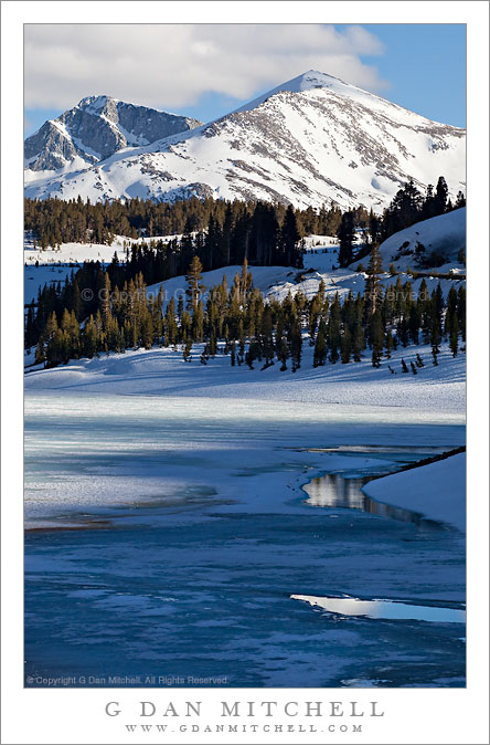
A late winter scene with ice-covered Tioga Lake and snow-capped Mammoth Peak at Tioga Pass, Yosemite National Park, California.
The view of Mammoth Peak from the Tioga Pass area is a favorite of mine, and I rarely cross the pass without stopping to at least take a look. My favorite light on Mammoth Peak comes late in the afternoon when it strikes the peak from the side, bringing the textures into relief, especially when there are still snow patches.
The conditions in this photograph are fleeting, in that the photograph was made during the brief interval between full high-country winter and the “summer” season, during which the lakes quickly become free of ice. On this early June day the late afternoon shadows of clouds and nearby peaks fall across the mostly frozen surface of Tioga Lake which is marked by a few areas that are beginning to melt out.
This photograph is not in the public domain and may not be used on websites, blogs, or in other media without advance permission from G Dan Mitchell.
Late afternoon shadows fall across the frozen surface of Tioga Lake with Tioga Pass and the snow-covered peaks of Kuna Crest beyond.
On June 5 I made my first “summer season” visit to the Sierra of the year. Usually I mark the start of the post-winter part of the year by heading to Yosemite Valley to experience the waterfalls close up during the peak flow of the meltwater-filled rivers. This year I had time for a one-day trip and I did, indeed, start in the Valley. The waterfalls are close to as big as they get right now, and the Merced River is close to reaching flood stage, with large meadow areas of the Valley already under water. (The latter is actually a normal condition at the peak of the runoff cycle.) However, after shooting in the Valley into mid-morning, I decided to head elsewhere because the crowds were oppressive and because tran-Sierra Tioga Pass Road had opened this very morning.
I’ve been over Tioga Pass Road before on or close to the first day that the route is open, but I haven’t seen conditions like these up there since the mid-1990s. (In 1996, IIRC, the pass didn’t open until July 1 after a very heavy and late winter.) There was still snow almost everywhere along the road. It would be possible to ski or snow-shoe in many areas and, in fact, there were people engaged in just those activities. Melting water was everywhere. In places where I have never seen water before there were roaring creeks, often pouring down next to or even onto the roadway. All lakes and ponds are nearly or completely frozen still. Tuolumne Meadows itself is still completely covered by snow… except where the flooding Tuolumne River has created a giant, fast-moving lake.
I made this photograph at Tioga Lake late in the afternoon after making a traditional visit to the “Who Nellie Deli” in Lee Vining for the ritual fish tacos. Long shadows from nearby peaks and clouds fall across the frozen surface of the lake, the saddle of Tioga Pass is beyond, and in the farthest distance it is still winter on the peaks of Kuna Crest.
This photograph is not in the public domain and may not be used on websites, blogs, or in other media without advance permission from G Dan Mitchell.
Lots of us northern and central California photographers make trips to the eastern Sierra in the summer and fall – I know that many of you have been there in the past month to photograph aspens and other fall color. For many of us the standard route to the “east side” is through Yosemite National Park and over Tioga Pass on State Highway 120 to Lee Vining and the area near Mono Lake. From here it is a short drive south to Mammoth (about a half hour) and Bishop (an hour) and points south, including Big Pine, Independence, and Lone Pine.
As the fall season arrives and winter weather approaches, Tioga Pass becomes a less reliable route and eventually closes for the season. The seasonal closure typically occurs sometime in late October or in November, though the historical records show that it has happened as late as January 1!
Photographer and visual opportunist. Daily photos since 2005, plus articles, reviews, news, and ideas.
Manage Consent
To provide the best experiences, we use technologies like cookies to store and/or access device information. Consenting to these technologies will allow us to process data such as browsing behavior or unique IDs on this site. Not consenting or withdrawing consent, may adversely affect certain features and functions.
Functional
Always active
The technical storage or access is strictly necessary for the legitimate purpose of enabling the use of a specific service explicitly requested by the subscriber or user, or for the sole purpose of carrying out the transmission of a communication over an electronic communications network.
Preferences
The technical storage or access is necessary for the legitimate purpose of storing preferences that are not requested by the subscriber or user.
Statistics
The technical storage or access that is used exclusively for statistical purposes.The technical storage or access that is used exclusively for anonymous statistical purposes. Without a subpoena, voluntary compliance on the part of your Internet Service Provider, or additional records from a third party, information stored or retrieved for this purpose alone cannot usually be used to identify you.
Marketing
The technical storage or access is required to create user profiles to send advertising, or to track the user on a website or across several websites for similar marketing purposes.