
Tag Archives: mud

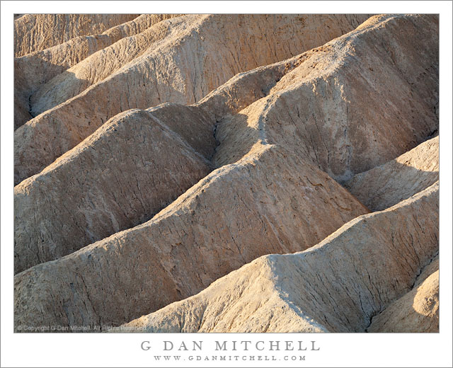
Morning Light, Zabriskie Point, Detail

Morning Light, Zabriskie Point, Detail

Morning Light, Zabriskie Point, Detail. Death Valley National Park, California. April 2, 2009. © Copyright 2009. G Dan Mitchell – all rights reserved.

Detail of eroded gullies and hills at the edge of Gower Gulch in morning light, Zabriskie Point, Death Valley National Park.

This photograph focuses on a small section of the contorted and folded geological shapes along the edges of Gower Gulch at Zabriskie Point in Death Valley National Park. These details fascinate me, not only for the amazing variety of forms that they present but also because they change continuously as the light changes. Here they are illuminated by fairly stark light from early morning sun light that has just appeared as the sun rose above the hills to the east. The contrasts between the brightly lit tops of the small hills and the deeply shadowed gullies is clear, but if you look closely you may be able to see that the shadows are lit, as well, by the light reflected into them from the obscured sunlit faces of the gullies that are not visible from this position.

When I return to Zabriskie, I may take a few moments to make photographs of momentary soft light as the first sun strikes Manley Beacon, but I have become much more interested in photographing these small details of the scene. I usually work with a very long lens, and continue to shoot long after the “golden hour” sunrise light has gone since some of the small subjects are better lit by higher light.

G Dan Mitchell is a California photographer whose subjects include the Pacific coast, redwood forests, central California oak/grasslands, the Sierra Nevada, California deserts, urban landscapes, night photography, and more.
Blog | About | Flickr | Twitter | Facebook | Google+ | 500px.com | LinkedIn | Email

Text, photographs, and other media are © Copyright G Dan Mitchell (or others when indicated) and are not in the public domain and may not be used on websites, blogs, or in other media without advance permission from G Dan Mitchell.
Hills and Gullies, Twenty Mule Team Canyon

Hills and Gullies, Twenty Mule Team Canyon

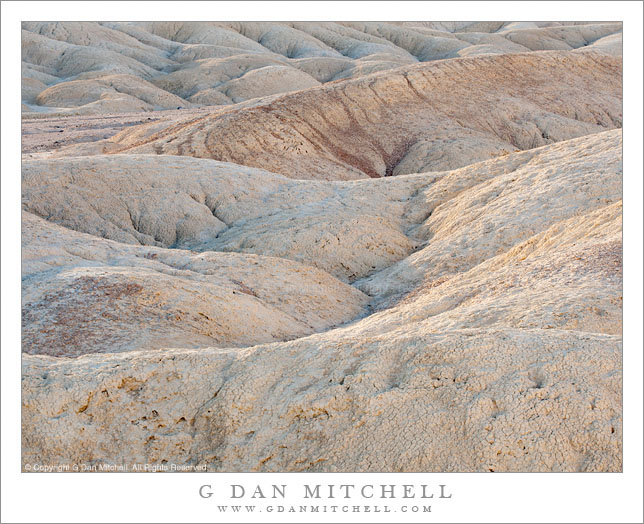
Hills and Gullies, Twenty Mule Team Canyon. Death Valley National Park, California. April 2, 2009 © Copyright 2009 G Dan Mitchell – all rights reserved.

Morning light across the shapes of hills and gullies, Twenty Mule Team Canyon, Death Valley National Park.

This is a photograph I made back in 2009 when I managed to get to Twenty Mule Team Canyon before sunrise and then continued to shoot for several hours. Though this area is very close to one of the most popular and oft-photographed locations in Death Valley National Park, it gets relatively few visitors from what I’ve seen. While it doesn’t generally present the huge and expansive vistas of some of the more famous areas, it is a great playground for those of us who enjoy the eroded and rounded landforms and the seemingly infinite variations of color and texture.

Here I tried to fill the frame completely with these shapes that have been produced by water eroding the relatively soft earth. The light was very interesting and a bit complex. Some diffused light was coming straight down from the sky, hence the bits of blue shadow in some of the gullies. At the same time, slightly diffused sunlight was directly striking the earth in a few spots. And in some of the foreground areas additional illumination was being reflected into the scene from nearby formations.

G Dan Mitchell Photography
About | Flickr | Twitter | FacebookGoogle+ | 500px.com | LinkedIn | Email

Text, photographs, and other media are © Copyright G Dan Mitchell (or others when indicated) and are not in the public domain and may not be used on websites, blogs, or in other media without advance permission from G Dan Mitchell.
(Basic EXIF data may be available by “mousing over” large images in posts when this page is viewed on the web. Leave a comment if you want to know more.)

Playa Surface, Panamint Valley

Playa Surface, Panamint Valley

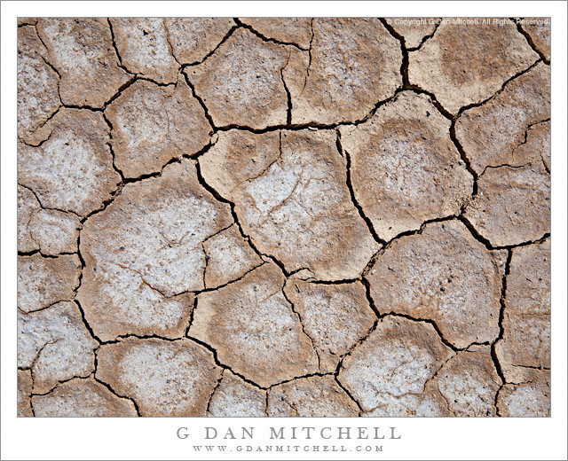
Playa Surface, Panamint Valley. Death Valley National Park, California. March 31, 2011. © Copyright G Dan Mitchell – all rights reserved.

Cracked and dry surface of the playa in Panament Valley, Death Valley National Park.

This micro-scene could be found in many locations in Death Valley and, for that matter, in many places in the USA and around the rest of the planet. But my little rectangle of the patterns of drying and cracked mud comes from the surface of the Playa (sometimes called “Panamint Lake?”) in upper Panamint Valley in Death Valley National Park. I wrote previously that it was the last day of my late-March photographic visit to Death Valley – I had finished my photography in the main Valley and had started the long drive back to the Bay Area. After crossing Towne Pass the road descends into Panamint Valley to a junction where I most often go south towards Trona and Ridgecrest and beyond.

Just before this junction the road crosses the playa, an extraordinarily flat surface formed when silt washed down from the surrounding mountains occasionally pools and gradually dries, forming what may be the flattest surfaces on the planet. As the moisture evaporates the mud cracks and splits into these interesting semi-geometrical patterns.

For no particular reason other than that this is a spot where I often make one final stop before leaving the park, I pulled over and wandered out onto the playa. I enjoy walking on these often-immense flat surfaces, but there is something very odd about the experience, too. Perhaps it is the slightly odd feeling of walking on such a large floor-flat surface in the natural world, or it might be the deep silence and stillness. In any case, as I wandered around not too far from the road I started looking a bit more closely at the patterns of cracks and soon decided that my photography was not quite finished yet – so I went back to the car to get my camera and made a small series of hand-held photographs with the camera pointing straight down. (The “straight down” shooting raises a question: How should the photograph be oriented? The horizontal orientation shown here is what I saw as I made the photograph… but I also wonder about rotating it 90″ clockwise.)

G Dan Mitchell Photography | Flickr | Twitter (follow me) | Facebook (“Like” my page) | LinkedIn | Email
Text, photographs, and other media are © Copyright G Dan Mitchell (or others when indicated) and are not in the public domain and may not be used on websites, blogs, or in other media without advance permission from G Dan Mitchell.

Branch on Playa, Panamint Valley

Branch on Playa, Panamint Valley

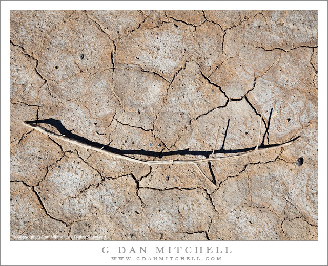
Branch on Playa, Panamint Valley. Death Valley National Park, California. March 31, 2011. © Copyright G Dan Mitchell – all rights reserved.

A lone branch lies across dried mud on the playa of Panamint Valley, Death Valley National Park.

First, a story about the location. My first visit to Death Valley was sometime in the late 1990s, when the “hiking and biking” club at my kids’ middle and high school did a trip there. The club is a long and interesting story that I don’t have time or space to describe here fully. Suffice it to say that the teacher, “Mr. Hodges,” had for decades taken kids on amazing outdoor adventures throughout the western United States every year, and that the trip that year was to involve visits to several places in the park and then a backpacking trip down to the Valley from up in the Teakettle Junction vicinity. This may sound like a crazy thing to do with a bunch of school kids, but the group had a record of success. I was along as a parent chaperone since my oldest son was a participant in the trip.

The “readers digest” version of the story of the trip is that, as is often the case near the beginning of April, we encountered an astonishing range of weather conditions. Early on it snowed and the wind blew at gale force levels. This forced us to abandon our initial backpacking plans after we had already camped overnight near Teakettle Junction, and to head back down to the Valley. We readjusted our plans and decided that we might still be able to do an overnight hike down the length of the upper Valley and (leaving out a bunch of intervening adventures in this narrative) we arrived at Stovepipe Wells and set up camp… just in time for a tremendous dust storm to blow in. The next morning the “bus” arrived that was to take the kids and a few of the chaperones home (the rest of us were in a truck carrying tons – literally – of gear on the roof rack and in a trailer) and we headed up to cross Towne Pass. It turned out that the “bus” (which was more or less a large airport shuttle-type van) was ill-equipped for these conditions and after struggling up the pass and then racing down the other side, the transmission blew out at the bottom of the descent into Panamint Valley. Those of us in the truck pulling the trailer arrived a few minutes later to find a group of scared kids and parents who had just experienced more excitement than they wanted.

I have a strong visual memory of “Mary,” one of the parents, who had just had a bit too much excitement walking quietly north away from the road and across this playa. Ever since that time, this place that most people would probably blow right past, has almost always warranted a stop as I passed by on my way out of the Valley. This trip was no exception. I left my camera gear in the car and just walked a ways out onto the playa. As I walked, even though I had been certain that my photography for this trip was finished, I started noticing some of the small details on the playa… and I went back to my car to get my camera, then returned and made a few hand-held exposures of some of these small subjects.

G Dan Mitchell Photography | Flickr | Twitter | Facebook | Email
Text, photographs, and other media are © Copyright G Dan Mitchell (or others when indicated) and are not in the public domain and may not be used on websites, blogs, or in other media without advance permission from G Dan Mitchell.