Tag Archives: playa

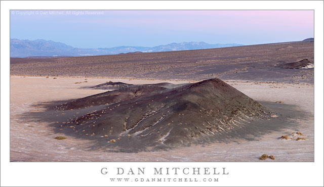
Hill Near Mesquite Flat, Dusk

Hill Near Mesquite Flat, Dusk

Hill Near Mesquite Flat, Dusk. Death Valley National Park, California. March 29, 2011. © Copyright G Dan Mitchell – all rights reserved.

Dusk light above a hill near Mesquite Flat in Death Valley, backed by a large alluvial fan from Tucki Mountain.

At the end of this day I was shooting from the top of a low hill in the Valley east of Stovepipe Wells, and there were interesting subjects throughout almost the entire 360 degree panorama around this elevated position. With this in mind, I had chosen to use the long 100-400mm zoom so that I could have some flexibility in composing elements of this huge scene.

I was mainly working with things that were in the large arc to my west (dunes and Cottonwood mountains and base of Tucki Mountain), north (the main Valley and transverse dunes), and east (the mountains running along that edge of the Valley) since the further subjects of the lower Valley were more or less out of sight beyond the alluvial fan that appears in the photograph. But I kept being intrigued by the low, dark hill on the flats below the similar hill on which I was standing. There is a row of them stretching from near the Devils Cornfield area up and across this alluvial fan. As the evening light transitioned towards post-sunset light I saw that the glow from clouds (a bit of which is visible in the distance above the Black Mountains) was lighting this hill and the surrounding flats in an interesting and colorful way.

But I had a little problem. I was still working a number of subjects and once and I really needed to keep shooting that 100-400. 100mm was still too long for this scene, but I didn’t have time to remove it and put on a shorter lens. I figured that I could simply change the camera to vertical orientation, very carefully level the tripod, and include the whole scene in four panning vertical frames that I could stitch together later. People often do this so that they can produce extremely high-resolution image, but that wasn’t my goal at all. In any case, it worked, and not only did I manage to get the shot that needed a wider lens, but as a bonus it is a very high-resolution shot.

G Dan Mitchell Photography | Flickr | Twitter (follow me) | Facebook (“Like” my page) | LinkedIn | Email
Text, photographs, and other media are © Copyright G Dan Mitchell (or others when indicated) and are not in the public domain and may not be used on websites, blogs, or in other media without advance permission from G Dan Mitchell.

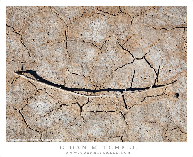
Branch on Playa, Panamint Valley

Branch on Playa, Panamint Valley

Branch on Playa, Panamint Valley. Death Valley National Park, California. March 31, 2011. © Copyright G Dan Mitchell – all rights reserved.

A lone branch lies across dried mud on the playa of Panamint Valley, Death Valley National Park.

First, a story about the location. My first visit to Death Valley was sometime in the late 1990s, when the “hiking and biking” club at my kids’ middle and high school did a trip there. The club is a long and interesting story that I don’t have time or space to describe here fully. Suffice it to say that the teacher, “Mr. Hodges,” had for decades taken kids on amazing outdoor adventures throughout the western United States every year, and that the trip that year was to involve visits to several places in the park and then a backpacking trip down to the Valley from up in the Teakettle Junction vicinity. This may sound like a crazy thing to do with a bunch of school kids, but the group had a record of success. I was along as a parent chaperone since my oldest son was a participant in the trip.

The “readers digest” version of the story of the trip is that, as is often the case near the beginning of April, we encountered an astonishing range of weather conditions. Early on it snowed and the wind blew at gale force levels. This forced us to abandon our initial backpacking plans after we had already camped overnight near Teakettle Junction, and to head back down to the Valley. We readjusted our plans and decided that we might still be able to do an overnight hike down the length of the upper Valley and (leaving out a bunch of intervening adventures in this narrative) we arrived at Stovepipe Wells and set up camp… just in time for a tremendous dust storm to blow in. The next morning the “bus” arrived that was to take the kids and a few of the chaperones home (the rest of us were in a truck carrying tons – literally – of gear on the roof rack and in a trailer) and we headed up to cross Towne Pass. It turned out that the “bus” (which was more or less a large airport shuttle-type van) was ill-equipped for these conditions and after struggling up the pass and then racing down the other side, the transmission blew out at the bottom of the descent into Panamint Valley. Those of us in the truck pulling the trailer arrived a few minutes later to find a group of scared kids and parents who had just experienced more excitement than they wanted.

I have a strong visual memory of “Mary,” one of the parents, who had just had a bit too much excitement walking quietly north away from the road and across this playa. Ever since that time, this place that most people would probably blow right past, has almost always warranted a stop as I passed by on my way out of the Valley. This trip was no exception. I left my camera gear in the car and just walked a ways out onto the playa. As I walked, even though I had been certain that my photography for this trip was finished, I started noticing some of the small details on the playa… and I went back to my car to get my camera, then returned and made a few hand-held exposures of some of these small subjects.

G Dan Mitchell Photography | Flickr | Twitter | Facebook | Email
Text, photographs, and other media are © Copyright G Dan Mitchell (or others when indicated) and are not in the public domain and may not be used on websites, blogs, or in other media without advance permission from G Dan Mitchell.
Moving Rock, Racetrack Playa

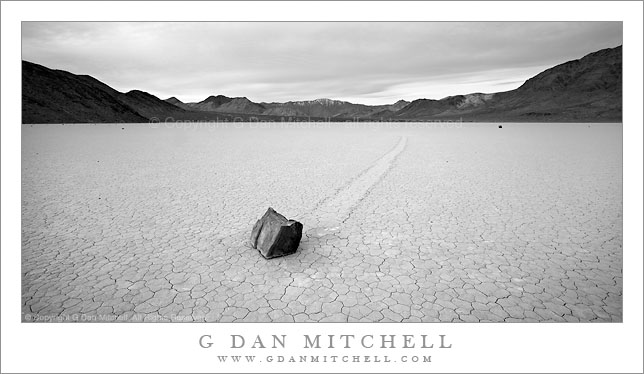
Moving Rock, Racetrack Playa

Moving Rock, Racetrack Playa. Death Valley National Park, California. March 29, 2010. © Copyright G Dan Mitchell – all rights reserved.

Black and white panoramic format photograph of a moving rock at Racetrack Playa, Death Valley National Park, California.

This photograph probably belongs in the “trying to turn lemons into lemonade” file. I’ve had wonderful luck with great light on all of my previous visits to the remote Racetrack Playa in Death Valley, the site of the “moving rocks” that have left tracks in their wake across the playa surface. However, my string luck seemed to run out on this late March visit. Earlier in the day as I contemplated whether or not to head out there I noticed some budding lenticular clouds to the north and made the decision to go. My preference is to have some clouds at the Racetrack, as perfectly clear sky isn’t as interesting in my view. Plus I always have in mind a particular previous visit when I photographed the playa at dawn with beautiful lenticulars building over the mountains to the north of the playa, and I think I’m always hoping for similar conditions again.

The plan on this visit was to arrive in the mid-afternoon to shoot the Grandstand, a formation near where the road first arrives at the playa, and to then photograph the beautiful evening light, the full moon (in the evening and then again before dawn) and finally the dawn light. The conditions continued to look great as I did the long washboard drive to the playa, and I arrived and photographed the Grandstand as planned. However, as I finished up here a high band of clouds moved across the sky and flattened out the light. As evening came on I was out on the playa, but the clouds remained and the light was not remarkable. I finally wandered back off the playa after dark, hoping that the clouds would clear and allow full moon photography. This never happened, and when I returned to the playa early in the morning the overcast was still present, with only a thin area of blue sky far to the west.

But I photographed anyway. Softer, overcast light has its potential, and since I was there I was certainly not going to waste the opportunity. In the end, I wasn’t thrilled with what I brought back for the most part, though I do like the effect of the overcast and the softer light on this black and white photograph of one of the more recognizable rocks. (By the way, the rest of my Death Valley visit went much better than this one night!)

This photograph is not in the public domain and may not be used on websites, blogs, or in other media without advance permission from G Dan Mitchell.
G Dan Mitchell Photography | Twitter | Friendfeed | Facebook | Facebook Fan Page | Email

Technical Data:
Canon EOS 5D Mark II
Canon EF 17-40mm f/4 L USM at 170mm
ISO 200, f/16, 1/8 second

keywords: sliding, moving, rock, trail, playa, surface, flat, cloudy, morning, inyo, mountains, hills, sky, clouds, monochrome, peak, snow, geology, nature, landscape, scenic, travel, death valley, national, park, california, usa, north american, remote, mystery, icon, light, flat, crack, earth, dry, desert, stock

Badwater Basin Salt Flats, Dusk

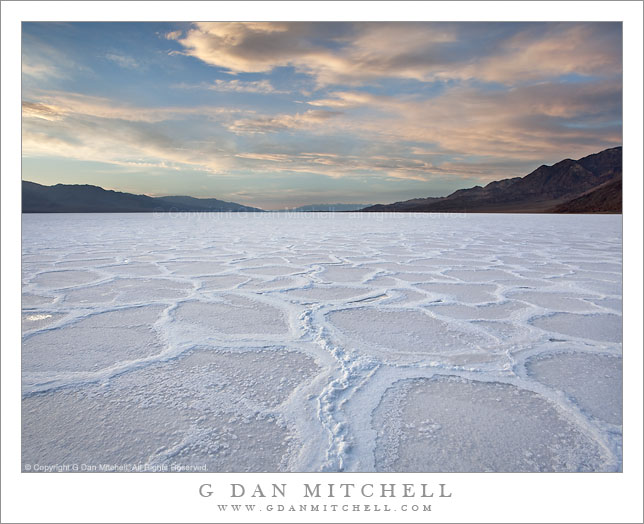
Badwater Basin Salt Flats, Dusk

Badwater Basin Salt Flats, Dusk. Death Valley National Park, California. March 29, 2010. © Copyright G Dan Mitchell – all rights reserved.

Newly formed salt polygons extend to the horizon as evening clouds gather above the Badwater Basin salt flats, Death Valley National Park, California.

This is one more – and perhaps the last – in a series of photographs I shot on a late-March evening in the Badwater Basin of Death Valley National Park. The light goes through a long and interesting transitional process at this location. Because of the tall Panamint Mountain range to the west, the direct sun leaves the surface of the salt flats quite early, though the hills along the east side of the valley and the more distant mountains can still be sunlit for some time. Once the sun drops behind the Panamints, the “white” salt actually can end up being quite blue since it is illuminated entirely by the diffused light from the blue sky. As I have mentioned before this creates some interesting subjective questions for the photographer. Should the salt be white? Should it be as blue as it looks in the capture? Should it be somewhere in between? I’ve seen interesting and effective photographs that seemed to take each of these approaches.

In this case, because I shot a bit before actual sunset and while some clouds reflected less blue light onto the playa surface, the need to alter to color balance was diminished a bit – which is not to say that I didn’t do some work to balance the colors so that they looked more like what I remembered. A second issues is related, namely that the sky remains very bright while the salt flat surface, in deep shade, is very dark by comparison. On the scene, the eyes/brain compensate and the difference seems less than what the camera records. So, again, some adjustment in post is needed. In this case I made two exposures one stop apart. On just barely handled the brightest portions of the sky without blowing out, while the other did a better job of holding the details for the shadowed salt formations. I combined the two source images in post.

This photograph is not in the public domain and may not be used on websites, blogs, or in other media without advance permission from G Dan Mitchell.
G Dan Mitchell Photography | Twitter | Friendfeed | Facebook | Facebook Fan Page | Email

Technical Data:
Canon EOS 5D Mark II
Canon EF 17-40mm f/4 L USM at 17mm
ISO 100, f/16, composite of 1/13 second and 1/6 second exposures

keywords: badwater, basin, salt, flat, desert, polygon, water, playa, crust, pattern, sky, cloud, evening, dusk, sunset, blue, mountain, ridge, range, distant, death valley, national, park, california, usa, north america, landscape, nature, scenic, travel, geology, horizon, stock