Tag Archives: river

Point Sur

Point Sur
Point Sur

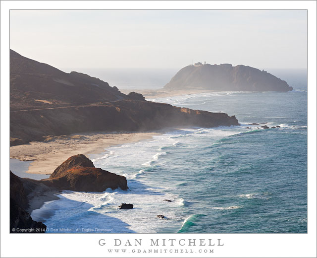
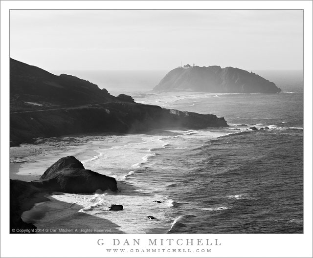
Point Sur. Pacific Coast Highway, California. January 31, 2014. © Copyright 2014 G Dan Mitchell – all rights reserved.

Pacific Ocean surf at the Point Sur Lighthouse near the mouth of the Little Sur River.

Point Sur is a dramatic landmark along the Big Sur coastline of California south of the Monterey area, standing apart from the main land mass and attached to it by a low peninsula with sand dunes and a beach facing north toward the Pacific. Virtually every time I have passed by here the wind has been howling, often kicking up clouds of ocean spray, or else it has been fogged in. The lighthouse itself sits near the right end of the point, as seen in this photograph, with other buildings along the highest ridge. I have yet to visit the historic structure, but I often stop along this section of the coast and try to photograph the point.

I made this photograph on a winter day when those strong winds were blowing and the winter seas were battering the north facing beach. This time I looked for a higher vantage point that would show the line of surf approaching the beach and include the silhouette of the coastal hills and bluffs at the edge of the sea. This image languished in my archive for nearly half a year before I returned to this set of images and saw that it could work in a monochrome rendition, and that this might even be a more dramatic way to show this scene.

G Dan Mitchell is a California photographer and visual opportunist whose subjects include the Pacific coast, redwood forests, central California oak/grasslands, the Sierra Nevada, California deserts, urban landscapes, night photography, and more.
Blog | About | Flickr | Twitter | FacebookGoogle+ | 500px.com | LinkedIn | Email

Text, photographs, and other media are © Copyright G Dan Mitchell (or others when indicated) and are not in the public domain and may not be used on websites, blogs, or in other media without advance permission from G Dan Mitchell.

Point Sur Lighthouse

Point Sur Lighthouse

Point Sur Lighthouse. Pacific Coast Highway, California. January 31, 2014. © Copyright 2014 G Dan Mitchell – all rights reserved.

The lighthouse at Point Sur, Big Sur Coast

We are now very close to summer, the time of year when, frankly, the Pacific Coast can be somewhat less exciting from a photographic perspective. From my point of view, winter is the time to visit and the time to photograph. In a typical year (and this was not a typical year) a pattern repeats for several month. Big Pacific storms roll through, building giant surf, bringing rain, and then clearing. In the wake of the storms there may be a series of sunny days—sometimes warmer than summer here!—that are broken by beautiful clouds. The light is often spectacular, ranging from the brilliant light of clear weather to the moody light when the atmosphere is filled with moisture.

Near the end of this past January we travelled down this coast, on one of those “typical winter days” when there was plenty of bright sun, but also mist and spray thrown up by the ocean. This location is iconic along this section of the Pacific Coast Highway. Near the outlet of the Little Sur River, this “almost island” of Point Sur stands at the end of a strand of beach extending out into the ocean, and a historic lighthouse stands on top of the hill. Descending toward this point from the north, the view extends right along the rugged shoreline and beach just north of the Point.

G Dan Mitchell is a California photographer and visual opportunist whose subjects include the Pacific coast, redwood forests, central California oak/grasslands, the Sierra Nevada, California deserts, urban landscapes, night photography, and more.
Blog | About | Flickr | Twitter | FacebookGoogle+ | 500px.com | LinkedIn | Email

Text, photographs, and other media are © Copyright G Dan Mitchell (or others when indicated) and are not in the public domain and may not be used on websites, blogs, or in other media without advance permission from G Dan Mitchell.

Mouth of the Little Sur River

Mouth of the Little Sur River

Mouth of the Little Sur River. Big Sur Coast, California. May 26, 2014. © Copyright 2014 G Dan Mitchell – all rights reserved.

The Little Sur river empties into the Pacific Ocean beneath the fog-shrouded mountains of the Big Sur coastline

It has been a very busy month or so, and since my early April trip to Death Valley, aside from a quick one-day visit to Tioga Pass on opening weekend, there has been less time for photography than I would like. I finally managed to find time to break away today, and I had enough desire to photograph that I was even willing to chance the Memorial Day traffic… along the Big Sur coast. I was up very early and on the road while most people were probably sleeping in, and as I passed Carmel and headed south it wasn’t all that crowded for such a day. However, after my first hour or two of photography, the crowds began to show up. I had decided that my plan would be to get the heck out of there before this happened, and as I turned back to the north I congratulated myself on not being in the traffic jam heading south on the coast highway. My joy was short-lived, however, and the rest of my return drive took at least twice as long as usual!

But, anything to get out for a morning along this coast! It was supposed to be warm along this section of the California coast today, and there wasn’t as much fog as usual. However, right in this area a stubborn bank of fog clung to the ridges of the Big Sur mountains, and as I drove along this section of the road the temperature dropped into the fifties and the wind blew like crazy. I almost didn’t stop at this overlook above the lagoon at the outlet of the Little Sur river, thinking that the wind might simply make it impossible to get a shot with the quality I wanted, but the beautiful curve in the green water of the lagoon, the fog bank, and the whitecaps on the deep blue Pacific convinced me to stop and give it a try.

G Dan Mitchell is a California photographer and visual opportunist whose subjects include the Pacific coast, redwood forests, central California oak/grasslands, the Sierra Nevada, California deserts, urban landscapes, night photography, and more.
Blog | About | Flickr | Twitter | FacebookGoogle+ | 500px.com | LinkedIn | Email

Text, photographs, and other media are © Copyright G Dan Mitchell (or others when indicated) and are not in the public domain and may not be used on websites, blogs, or in other media without advance permission from G Dan Mitchell.

Spring Flooding, Tuolumne Meadows

Spring Flooding, Tuolumne Meadows

Spring Flooding, Tuolumne Meadows. Yosemite National Park, California. May 4, 2014. © Copyright 2014 G Dan Mitchell – all rights reserved.

The Tuolumne River overflows its banks on a spring evening, Tuolumne Meadows

This is another, slightly different view of a scene that I shared recently, photographed at Tuolumne Meadows on the weekend when Tioga Pass Road over the Sierra crest opened for the 2014 season. As is my habit, I broke free and made it up there to celebrate the beginning of a new high country season. It was a quick trip—a 21 hour 550 mile drive that took me across the range to the Mono Lake area and some nearby sights on the “east side.” Later in the day I reversed course and headed back up to Tioga Pass and began my homeward trip, stopping to spend a good part of the evening in Tuolumne Meadows, where strong wind blew as the golden hour light began to develop.

This scene is full of things that I know well. I have visited the general area of Tuolumne Meadows since I was a child and my father took me and one of my brothers up there on the first camping trip that I can remember. Every spring (or early summer in wet years) when I return I look for this area of the meadow where the Tuolumne River overflows its banks and produces a temporary lake, even in a very dry year like this one. On a number of occasions I have hiked on a trail that crosses from right to left just below the bright granite peak in the upper left, heading for a pass below Ragged Peak and then on to Young Lakes, which lie just beyond that highest ridge. (Just below and to the left of the granite peak lies a beautiful area of subalpine meadow with scattered rocks and extensive fields of lupine.) On this evening there were few people in the meadow, as the campground was not yet open and not many people were still up here so late in the day, so I was able to wait quietly for the clouds and the light to line up just right.

G Dan Mitchell is a California photographer and visual opportunist whose subjects include the Pacific coast, redwood forests, central California oak/grasslands, the Sierra Nevada, California deserts, urban landscapes, night photography, and more.
Blog | About | Flickr | Twitter | FacebookGoogle+ | 500px.com | LinkedIn | Email

Text, photographs, and other media are © Copyright G Dan Mitchell (or others when indicated) and are not in the public domain and may not be used on websites, blogs, or in other media without advance permission from G Dan Mitchell.