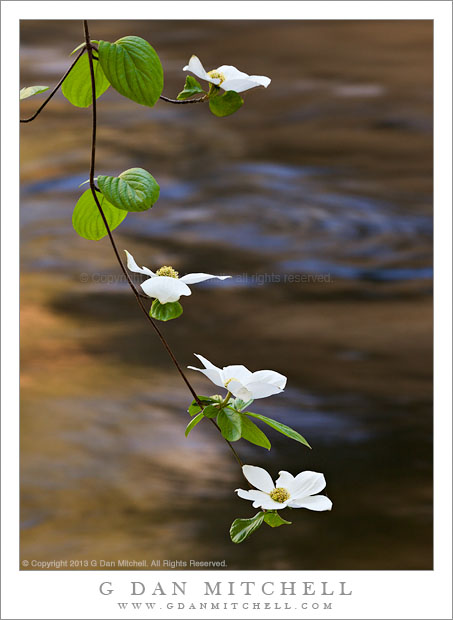
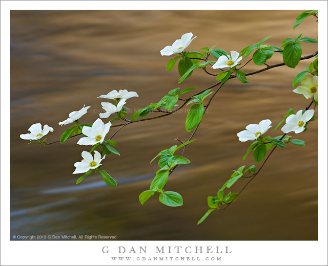
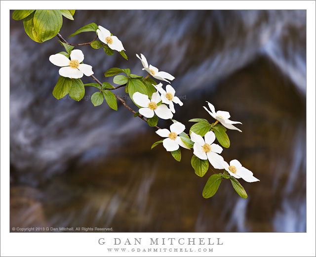
Tag Archives: river

Sandstone Tower, Fruita District

Sandstone Tower, Fruita District

Sandstone Tower, Fruita District. Capitol Reef National Park, Utah. October 8, 2012. © Copyright 2012 G Dan Mitchell – all rights reserved.

A sandstone tower stands above the Fruita District orchards in early evening light, Capitol Reef National Park

These sandstone plateaus and mesas seem characteristic of this front-country area of Capitol Reef National Park, and they are perhaps the most striking visual icon of your approach to the park from the town of Torrey, Utah, to the west. The Fruita District is the most accessible area of the park, being right alongside the main east-west highway that passes through the park. It features some picturesque sites and sights that are enough to make almost anyone pull over and look, including the old orchards that apparently gave the area its name and the accessible petroglyphs on low cliffs that run along the road. (Although this portion of the park is quite accessible once you are out here and driving across Utah, most of the park is anything but easily accessible, and getting to other places within its boundaries can involve some very long drives on some fairly bad roads, plus some hiking. I’m fine with that! ;-)

I made this photograph late in the day, after we had done a bit of exploring along the main tourist route into the park, the largely paved road towards Capitol Gorge and other nearby points. Late in the day I happened to spot this little conjunction of creek and fall-color tree and green grass and red rock cliffs as we were about to leave the park.

G Dan Mitchell is a California photographer and visual opportunist whose subjects include the Pacific coast, redwood forests, central California oak/grasslands, the Sierra Nevada, California deserts, urban landscapes, night photography, and more.
Blog | About | Flickr | Twitter | FacebookGoogle+ | 500px.com | LinkedIn | Email

Text, photographs, and other media are © Copyright G Dan Mitchell (or others when indicated) and are not in the public domain and may not be used on websites, blogs, or in other media without advance permission from G Dan Mitchell.

Cottonwood Grove and Cliff, Autumn

Cottonwood Grove and Cliff, Autumn - A cottonwood grove in golden fall colors, Grand Staircase-Escalante National Monument
A cottonwood grove in golden fall colors, Grand Staircase-Escalante National Monument

Cottonwood Grove and Cliff, Autumn. Grand Staircase-Escalante National Monument, Utah. October 24, 2012. © Copyright 2012 G Dan Mitchell – all rights reserved.

A cottonwood grove in golden fall colors, Grand Staircase-Escalante National Monument

In late October these bright yellow-gold cottonwood trees seem to be almost everywhere in Utah, albeit at slightly different stages of color development. Some are still mostly green with just a hint of yellow, while others have lost most of their leaves. From what I can tell, the difference in the pattern of change relate to things such as elevation, whether the trees are in sheltered canyons – in Zion Canyon they seem to change much later – or out in the open, and other causes that I don’t yet understand. One thing I do know: Between the aspens, which change color several weeks earlier, and the cottonwoods it seems like the entire month of October produces a lot of fall color. From what I hear it even extends into November, though I haven’t been there during that month to see it for myself.

On this day we began early with very cold hike into a portion of the Escalante River, which runs for quite a good distance through this section of Utah. Before the day was over we were challenged by strong wind, more cold, and eventually even a bit of light rain, but early on when I made this photograph the conditions were still bit less challenging, at least as far as the wind was concerned. Here the water course ran very close to the cliff wall, and clumps of golden cottonwoods grew between the water and the sandstone face. Although some direct light was beginning to strike the upper canyon walls and reflect light down into the canyon, here at the bottom along the creek the light was still soft and diffused.

G Dan Mitchell is a California photographer whose subjects include the Pacific coast, redwood forests, central California oak/grasslands, the Sierra Nevada, California deserts, urban landscapes, night photography, and more.
Blog | About | Flickr | Twitter | FacebookGoogle+ | 500px.com | LinkedIn | Email

Text, photographs, and other media are © Copyright G Dan Mitchell (or others when indicated) and are not in the public domain and may not be used on websites, blogs, or in other media without advance permission from G Dan Mitchell.

Colorado River, Dead Horse Point

Colorado River, Dead Horse Point

Colorado River, Dead Horse Point. Deadhorse Point State Park, Utah. October 10, 2012. © Copyright 2013 G Dan Mitchell – all rights reserved.

The canyon of the Colorado River, from Dead Horse Point State Park, Utah

The light was a bit tricky when we drove out to Dead Horse Point to look at the famous view of the Colorado River as it loops below huge cliffs at the edge of Canyonlands National Park in Utah. It was nearing the middle of the day, so the soft morning and evening light was nowhere to be found. It was also hazy, with the slightly opaque air taking on distinctly blue colors. For all of these reasons, and also perhaps as a nod to old school landscape photography, I went with a black and white rendition of this photograph.

This is a truly remarkable bit of terrain. First, in the bottom of the canyon the Colorado River negotiates and abrupt horseshoe bend here beneath the tall cliffs leading up to the “Island in the Sky” portion of Canyonlands National Park. Above the river are a series of huge terraces form as the river eroded its way though the deep and old layers of sedimentary rock that characterize this area. Shooting with a slightly long focal length, I was able to eliminate most extraneous subjects and crop tightly around this area of massive cliffs and terraces.

G Dan Mitchell is a California photographer and visual opportunist whose subjects include the Pacific coast, redwood forests, central California oak/grasslands, the Sierra Nevada, California deserts, urban landscapes, night photography, and more.
Blog | About | Flickr | Twitter | FacebookGoogle+ | 500px.com | LinkedIn | Email

Text, photographs, and other media are © Copyright G Dan Mitchell (or others when indicated) and are not in the public domain and may not be used on websites, blogs, or in other media without advance permission from G Dan Mitchell.

Little Sur River, Pacific Ocean

Little Sur River, Pacific Ocean

Little Sur River, Pacific Ocean. Big Sur Coast, California. January 19, 2013. © Copyright 2013 G Dan Mitchell – all rights reserved.

The Little Sur River meets the Pacific ocean along the Big Sur coastline of California in evening light

On this weekend near the middle of January, the local news and weather reports announced the arrival of very large winter surf along the central and northern California coast. This typically happens a few times every winter, when very distant storms far to the north in the Pacific Ocean near the Aleutian Islands send huge swells south towards California. For those whose experience with the California coast has mainly been to experience the usually gentle surf on summer, these waves can be stunning. When I heard about these conditions I knew I had to make it over to the coast. The setup this weekend was special in another way – the period between large waves was rather long and the larger sets of waves were separated by many minutes. We saw this process in action when we first arrived to find what looked like surprisingly calm seas, with only rather normal looking waves. But within minutes a set of the larger waves began to come ashore and we were astounded at their size and power.

This weekend was doubly special. Not only was the monumental winter surf running, but we had a spell of that weather than can make people from other places envy Californians! We went south from Monterey and into the upper reaches of the Big Sur coastline, where it was beautifully sunny and close to 70 degrees! (For those who think this is actually typical… not quite! In the summer this area is often blanketed by thick fog for days on end.) The waves and the weather drew thousands to the shoreline, and I can’t recall the last time I saw so many people along the coast highway. We joined them and made quite a few photographs during the afternoon hours. At the same time I was scoping out possible locations for that final golden-hour photograph. As the end of the day approached we were very close to Big Sur itself, and I remembered stopping at this spot a bit earlier in the day and thinking about how to compose a photograph of the peninsula separating the curving Little Sur River from the steep cliffs and ocean beyond.

G Dan Mitchell is a California photographer and visual opportunist whose subjects include the Pacific coast, redwood forests, central California oak/grasslands, the Sierra Nevada, California deserts, urban landscapes, night photography, and more.
Blog | About | Flickr | Twitter | FacebookGoogle+ | 500px.com | LinkedIn | Email

Text, photographs, and other media are © Copyright G Dan Mitchell (or others when indicated) and are not in the public domain and may not be used on websites, blogs, or in other media without advance permission from G Dan Mitchell.