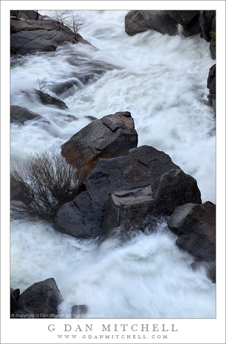
Tag Archives: road

Boulders and Spring Torrent, Cascade Creek

Boulders and Spring Torrent, Cascade Creek

Boulders and Spring Torrent, Cascade Creek. Yosemite National Park, California. May 7, 2011. © Copyright G Dan Mitchell – all rights reserved.

Runoff from spring snow melt rushes over boulders of Cascade Creek, Yosemite National Park.

This is a subject that I return to several times each year – a particular section of creek that can be viewed from overhead and which can vary from nearly dry to a wild torrent depending upon the time of year and the character of each new year. During the past year I was inspired by Charles Cramer’s stunning photograph of this subject to look at it more closely and from some different perspectives. (A small bit of “Charlie’s scene” appears in this photograph. I wonder if you can find it? :-)

In some ways, the view of this scene is limited in that you can only see it from a particular range of positions – unless you have the skill of levitation! In another way it is hardly limiting at all since the larger view contains many possible smaller views of rocks and plants and water and light. I still have in mind a horizontal composition in this general area, but so far it hasn’t quite worked. Guess I’ll have to keep trying.

I made this photograph in the morning before any direct light had worked its way around the mountains and down into the stream bed. Beyond the stream, which drops precipitously into the Merced River far below, there was open sky and that is the light that reflects on some of the wet rocks. By playing around to find an appropriate combination of ISO values, aperture, and shutter speed, I tried to get the water to hold some detail but to also be blurred enough to reflect its wild motion as it tumbles down this rocky canyon.

As is sometimes the case, I still cannot decide for sure between this monochrome version and a color version that will appear here before long.

G Dan Mitchell Photography | Flickr | Twitter (follow me) | Facebook (“Like” my page) | LinkedIn | Email
Text, photographs, and other media are © Copyright G Dan Mitchell (or others when indicated) and are not in the public domain and may not be used on websites, blogs, or in other media without advance permission from G Dan Mitchell.

Pacific Coast Near Bixby Creek

Pacific Coast Near Bixby Creek

Pacific Coast Near Bixby Creek. Big Sur, California. May 13, 2011. © Copyright G Dan Mitchell – all rights reserved.

The blue Pacific Ocean and rugged fog-topped coastal hills meet along the Big Sur coastline at Bixby Creek.

On a nearly perfect spring morning – despite the ominous sounding Friday the 13th date! – I spent a morning along the upper Big Sur coast below Monterey, California. The brilliant sun was modulated a bit by some atmospheric haze over the ocean and occasional fog clouds clustered around the tops of the coastal hills. Since I made quite a few stops along the way, I only went as far south as the iconic Bixby Bridge. This photograph was made from very near the spot where thousands (including me!) have photographed the bridge itself – it is out of the frame to the left. On this morning, the bridge didn’t interest me much at all, so I instead photographed the wild and steep coastline, with its spring green contrasting with the brilliant blues of the coastal waters below the rugged cliffs. At the very lower left corner, Bixby Creek flows across the beach and into the Pacific Ocean. Above, the coast highway rises across the top of the coastal bluffs on its way south.

G Dan Mitchell Photography | Flickr | Twitter (follow me) | Facebook (“Like” my page) | LinkedIn | Email
Text, photographs, and other media are © Copyright G Dan Mitchell (or others when indicated) and are not in the public domain and may not be used on websites, blogs, or in other media without advance permission from G Dan Mitchell.

Ellery Lake

Ellery Lake
Ellery Lake

Ellery Lake. Sierra Nevada near Yosemite, California. June 29, 2010. © Copyright G Dan Mitchell – all rights reserved.

Early season morning light on Ellery Lake near Tioga Pass.

I made this photograph on the same early-season morning on which I made the vertical format photograph of the same scene that I recently posted. Ellery Lake is alongside highway 120, the “Tioga Pass Road,” just beyond the eastern boundary of the park and the Sierra crest. To be completely forthcoming, I made this photograph from the side of the road! (The many individuals who know this area well, and who have probably stopped to look at the same scene, already knew that…)

To briefly recap, the road here curves around the upper end of the lake above this small bay. Looking across the bay, the rocky edges of the lake are visible along with the steep talus slopes ascending to the peaks around Mt. Dana beyond. The spot has a natural beauty in terms of the forms of the landscape, but I think it is difficult to photograph as a whole – the light is the tricky thing. The earliest morning light is block by high peaks to the east and the late afternoon light goes quickly from sun to shade as the sun drops below ridges behind the camera position, and this light can be fairly flat since it comes from directly behind. This photograph was made in the morning, but not close to sunrise at all – it was two or three hours later. Even here the scene isn’t without technical challenges, especially from the dynamic range that spans from the shadows behind backlit rocks and trees to the very bright snow fields at upper right.

G Dan Mitchell Photography | Flickr | Twitter | Facebook | Email
Text, photographs, and other media are © Copyright G Dan Mitchell (or others when indicated) and are not in the public domain and may not be used on websites, blogs, or in other media without advance permission from G Dan Mitchell.

Morning, Ellery Lake

Morning, Ellery Lake

Morning, Ellery Lake. Eastern Sierra Nevada near Yosemite. June 29, 2010. © Copyright G Dan Mitchell – all rights reserved.

Morning light on Ellery Lake and surrounding mountains near Tioga Pass.

Yosemite National Park visitors who enter or leave the park via the Tioga Pass Road route are familiar with the sub-alpine lakes just east of the pass including Tioga Lake, Ellery Lake, and many smaller ponds. Ellery Lake – which is made a bit higher by a dam on its outlet stream – is the last lake before the drop-off into Lee Vining Canyon, and a place that people often stop during the summer months. Even during the very early and late season it is a popular place – in the early season right after the road opens you can often see back-country skiers on the steep slopes above the lake.

I rarely pass this particular cove near the upper end of the lake without stopping. However, I have also found it a tricky photographic subject! Very early light is blocked by the very tall ridge whose lower slopes are seen in the distance in this photograph. It is often quite windy. Late in the day the color of the light can be special, but it also tends to be almost directly behind the photographer and to leave some deep foreground shadows. There are other places like this – they seem like they should be photographic “slam dunks,” but they turn out to be more difficult than they appear. Or maybe it is just me! :-)

In any case, on this late June morning I had earlier finished photographing in the Mono Lake area and was heading back up towards Tuolumne Meadows. And, as always, as I drove around the curve above this cove I caught a view of the lake out of the corner of my eye and couldn’t resist stopping.

G Dan Mitchell Photography | Flickr | Twitter | Facebook | Email
Text, photographs, and other media are © Copyright G Dan Mitchell (or others when indicated) and are not in the public domain and may not be used on websites, blogs, or in other media without advance permission from G Dan Mitchell.