Tag Archives: yosemite

Dogwood Thicket and Forest, Evening

Dogwood Thicket and Forest, Evening

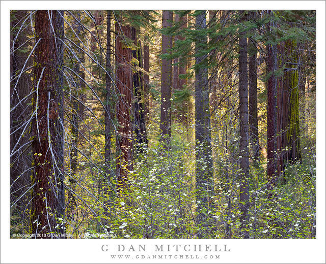
Dogwood Thicket and Forest, Evening. Yosemite National Park, California. May 11, 2013. © Copyright 2013 G Dan Mitchell – all rights reserved.

Blooming dogwoods among the conifer forest in evening light, Yosemite National Park

Among photographers and others who watch the seasons change in the Sierra, the spring blossoming of the Yosemite Valley dogwood trees is an important indicator that winter is over, spring is here, and summer cannot be far away. At the right time, in many locations in The Valley these flowers can bloom profusely, and this year’s bloom was exceptional. However, many who focus their visits on the brief (a week or two?) bloom in Yosemite Valley may overlook the beautiful though perhaps a bit different bloom that continues in the higher country.

I was in the Valley on this early May day for various reasons, but as evening approached I decided to drive up out of the Valley to a particular little tree-filled Valley where I often stop – in spring for the dogwood flowers and in fall for the autumn colors of these trees. I arrived during the hour before sunset when the late sunlight still shines over the top of a low ridge to the west and filters through the mixed forests to backlight the thickets of dogwood trees growing among the more typical forest trees of the area, and I spent the evening quietly looking and walking among the trees of this little section of forest.

(Note: This photograph was made in late spring, but it appears on my blog in early September… following the gigantic “Rim” fire in the vicinity of the northwest boundary of Yosemite National Park. From what I can tell from the fire maps on the Internet, there is a possibility that these trees are now gone, though I have not had a chance to check yet. They are/were on the west side of the road that formed one of the fire breaks, so I’m hopeful that they might have been saved. I’ll know soon.)

G Dan Mitchell is a California photographer and visual opportunist whose subjects include the Pacific coast, redwood forests, central California oak/grasslands, the Sierra Nevada, California deserts, urban landscapes, night photography, and more.
Blog | About | Flickr | Twitter | FacebookGoogle+ | 500px.com | LinkedIn | Email

Text, photographs, and other media are © Copyright G Dan Mitchell (or others when indicated) and are not in the public domain and may not be used on websites, blogs, or in other media without advance permission from G Dan Mitchell.

Trees and Boulder, Morning

Trees and Boulder, Morning

Trees and Boulder, Morning. Yosemite National Park, California. August 6, 2013. © Copyright 2013 G Dan Mitchell – all rights reserved.

Morning light on a boulder and a small group of trees growing on a granite slab in the Yosemite high country.

I suppose this sort of shot is turning up with a great deal of frequency among my photographs. I can’t help myself – I’m crazy about the combination of back (or side) lit trees, granite slabs and boulders, and haze obscured mountains, forests, and domes. I suppose this may be because such views, especially early and late in the day, seem to me to characterize the high country of Yosemite as much as just about any other feature.

This group of trees grows in a well-known location, and I drove to it before sunrise so that I could be out and about and looking for light from the get-go. This is a location that I have shot quite a few times in the past, so I feel like I’m getting more of a handle on what some of the possibilities and potentials are. On this morning I began nearby in a spot where there were lots of long shadows still, and after the sun rose a bit higher I moved on to this area of granite slabs and glacial erratic boulders, looking for trees that could stand against the more distant background of the glaciated granite forms with sparse trees growing here and there – in fact, on that far ridge they grow much the same way as the trees that are the central focus of this image.. There is almost always some haze here at this time of day, but it may have been just a bit thicker than usual due to a fire on the east side of the Sierra.

G Dan Mitchell is a California photographer and visual opportunist whose subjects include the Pacific coast, redwood forests, central California oak/grasslands, the Sierra Nevada, California deserts, urban landscapes, night photography, and more.
Blog | About | Flickr | Twitter | FacebookGoogle+ | 500px.com | LinkedIn | Email

Text, photographs, and other media are © Copyright G Dan Mitchell (or others when indicated) and are not in the public domain and may not be used on websites, blogs, or in other media without advance permission from G Dan Mitchell.

Boulders, Tree, and Dark Granite

Boulders, Tree, and Dark Granite

Boulders, Tree, and Dark Granite. Yosemite National Park, California. August 6, 2013. © Copyright 2013 G Dan Mitchell – all rights reserved.

A solitary tree stands on granite slabs among glacial erratic boulders against the dark background of a granite face in shadow

I have previously posted a few photographs from this early August four-day shoot in Yosemite, when I ranged between about Olmsted Point and Mono Lake for about four days. The photography was a bit strange compared to more normal years – there was smoke in the air from a fire near Mammoth Lakes and there was not much water due to the drought afflicting the mountains after a second very dry winter. So some of my photography instincts may have been challenged a bit, and I had to adapt to conditions – sometimes ending up shooting in a different place than planned when the haze was too thick, sometimes using the haze as part of the photograph, and also ranging a bit more widely than I might usually do.

On this morning I had decided to “work” that area between roughly Tenaya Lake and some rocky slabs a bit past Olmsted Point. I began at Tenaya just before sunrise, but the smoke haze was making things difficult. I made a few photographs along the curving shore as the first sun hit nearby ridges, but I wasn’t especially happy with the atmosphere or the color and quality of the light so I moved on. The slabs and domes along the road to the west of Tenaya Lake, which track the road for some distance and spread well beyond the road itself, have been an ongoing subject of interest to me. While the sun had hit the highest peaks by the time I got there, it had not quite worked its way down to these slabs, so I found some likely groups of glacial erratic boulders and various small trees and made some photographs. In this one, a single tree stands beyond a group of large boulders that had just been hit by the first light, and across a nearby canyon large granite walls are still in shadow.

G Dan Mitchell is a California photographer and visual opportunist whose subjects include the Pacific coast, redwood forests, central California oak/grasslands, the Sierra Nevada, California deserts, urban landscapes, night photography, and more.
Blog | About | Flickr | Twitter | FacebookGoogle+ | 500px.com | LinkedIn | Email

Text, photographs, and other media are © Copyright G Dan Mitchell (or others when indicated) and are not in the public domain and may not be used on websites, blogs, or in other media without advance permission from G Dan Mitchell.

About the Yosemite “Rim” fire… and more

UPDATE and a NOTE:

Update: Shortly after I posted this, my reports on highway 120 through the park via the Tuolumne Meadows area  were rendered incorrect/outdated by way of an updated announcement from the park service as follows:

“Beginning at 12:00pm on Wednesday, August 28th, Tuolumne Meadows and the High Sierra will only be accessible via Highway 120 East through Lee Vining.  The Tioga Rd/Hwy 120 East will be temporarily closed between White Wolf Lodge and the Big Oak Flat Rd./Hwy 120 West at Crane Flat; the closure is estimated to be 3 to 4 days.  Tuolumne Meadows Lodge, the High Sierra Camps, and Tuolumne Meadows and Porcupine Flat campgrounds all remain open.”

Basically, this means that you will not be able to use highway 120 as a route across the Sierra until further notice. I’m not surprised – in fact, I’ve been somewhat surprised that the road remained open this long. Apparently the following URL is also a good source of updates from the park: http://www.yosemitepark.com/yosemite-fire-update.aspx

Note: All of which brings me back to my original statement that I don’t have inside information on this fire, and that anyone traveling to the area needs to check official sources for conditions updates. I will likely not update this page as things change, so the information posted here should be regarded as potentially being out of date!

My original post follows…

A few people have asked me for information about the “Rim” fire which started not far from Groveland near highway 120, and which is currently burning along the northwest boundary of Yosemite National Park, generally moving east and north toward the highway 108 area. While I know much of this area fairly well from many years (decades, actually) of visits, I do not have any inside information about the fire itself, nor am I an expert on wildfires. One good source of (limited but objective) information is the Stanislaus National Forest Rim Fire Incident web page. A map on this page is a quite amazing source of information, especially when combined with some familiarity with the area and a reading of various written reports. (The version on the main page seems to be based on Google Maps, and allows you to scroll around and zoom in.) Lots of folks who live and work in the area are sharing updates on the usual social media sites. The Mariposa Gazette is another local news source.

The fire started on August 17 more or less midway between Groveland and the  northwest park entrance and not far off of the highway 120 corridor near the Rim of the World area overlooking the canyon of the Tuolumne River. (Highway 120 is a common route for entry to the park from the west and northwest, and it connects via Tuolumne Meadows and Tioga Pass to the east side of the Sierra at the town of Lee Vining.) The spread of the fire at first was somewhat quick, which is no surprise given the extremely dry conditions in the Sierra following a second very dry winter and almost no real precipitation since late 2012. Then, between about August 20 and 23, the fire exploded, expanding  very quickly to cover a huge area generally to the east and north of the starting point, with the fire generally racing northeast but also spreading to the north and south. Continue reading About the Yosemite “Rim” fire… and more