Tag Archives: bluff

Land Meets Sea

Land Meets Sea
Steep coastal ridges run down to the edge of the Pacific Ocean, Northern California

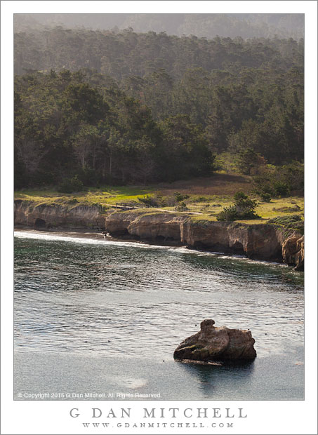
Land Meets Sea. Mendocino County, California. July 6, 2015. © Copyright 2015 G Dan Mitchell – all rights reserved.

Steep coastal ridges run down to the edge of the Pacific Ocean, Northern California

Having lived not far from the Pacific Ocean for more than a couple of decades, I am lucky to have regular access to the California coastline and its often dramatic meeting of land and sea. Due to proximity, my home territory is the section between just north of San Francisco and down through the upper portions of the Big Sur coast. The shouldn’t be any surprise, given the number of photographs of that area that I have made.

Oddly, for a near-native Californian, I had little experience with the coastline farther north. I had made it up as far as Fort Ross a few times, but every time I went north in the state I headed inland. Some years back we began to rectify this omission with some visits to the Mendocino area. I still haven’t gotten my mind completely around photographing this particular coast, but I’m learning. While we think of the coast as being somewhat civilized, with roads traversing it and passing from town to town, the actual meeting of land and water remains mostly a rugged wilderness. I made this photograph from a spot that it at the edge of one of these wilderness sections, where the roads cut inland and leave the coast to the birds and the sea life.


G Dan Mitchell is a California photographer and visual opportunist. His book, “California’s Fall Color: A Photographer’s Guide to Autumn in the Sierra” is available from Heyday Books and Amazon.
Blog | About | Flickr | Twitter | FacebookGoogle+ | 500px.com | LinkedIn | Email


All media © Copyright G Dan Mitchell and others as indicated. Any use requires advance permission from G Dan Mitchell.

Whalers Cove

Whalers Cove
Whalers Cove

Whalers Cove. Point Lobos, California. March 15, 2015. © Copyright 2015 G Dan Mitchell – all rights reserved.

Whalers Cove at the Point Lobos State Reserve

People who head straight toward the ocean at Point Lobos, driving west through the park and then south, probably miss this spot completely since it is off to the side and down a hill a bit. It is very popular with divers and recently I’ve seen kayakers working out of the cove. It is also a good place to find various sorts of birds — on more than one occasion I’ve photographed egrets standing on seaweed and hunting for meal.

This time I hiked up the trail that climbs away from the cove and towards the north shore of the park with its cypresses and steep cliffs dropping to the water. From the early part of the climb I could look back over the cove and see the small meadow at its head and the layers of forest and hills beyond as they rise toward the ring of the coastal hills across and beyond the Pacific Coast Highway.


G Dan Mitchell is a California photographer and visual opportunist whose subjects include the Pacific coast, redwood forests, central California oak/grasslands, the Sierra Nevada, California deserts, urban landscapes, night photography, and more.
Blog | About | Flickr | Twitter | FacebookGoogle+ | 500px.com | LinkedIn | Email

Text, photographs, and other media are © Copyright G Dan Mitchell (or others when indicated) and are not in the public domain and may not be used on websites, blogs, or in other media without advance permission from G Dan Mitchell.

Point Sur Lighthouse Station

Point Sur Lighthouse Station

Point Sur Lighthouse Station. Big Sur Coast, California. July 24, 2014. © Copyright 2014 G Dan Mitchell – all rights reserved.

The historic lighthouse station atop Point Sur along the California Big Sur coastline

Point Sur, with its historic lighthouse station, is an iconic feature of the northern section of the Big Sur coastline along the Pacific Coast Highway in California. The distinctive “hill” (which I now know is known as a “morro”) is visible from far up the coast as you approach from the north, and once you get closer the tall, rounded hill at the far end of a sandy peninsula has a nearly unique appearance. (Not literally unique, as there are others, such as the eponymous Morro Rock further south at Morro Bay.)

Today the morro itself, with its lighthouse station structures, plus an old naval facility nearby, are part of the state park system. The surrounding land is still in private hands, but Californians and others can hope that it, too, may eventually expand the public land along the coast. The lighthouse station was constructed in the late 1800s, when this was a very remote section of the California coast, and the lighthouse staff and their families had to be nearly self-sufficient. The area is exposed to significant winds and surf, as it is exposed to the north. Today the lighthouse still works, though with a modern replacement for the original light. If you look closely you may be able to see the light along the descending ridge on the right side of the morro.

G Dan Mitchell is a California photographer and visual opportunist whose subjects include the Pacific coast, redwood forests, central California oak/grasslands, the Sierra Nevada, California deserts, urban landscapes, night photography, and more.
Blog | About | Flickr | Twitter | FacebookGoogle+ | 500px.com | LinkedIn | Email

Text, photographs, and other media are © Copyright G Dan Mitchell (or others when indicated) and are not in the public domain and may not be used on websites, blogs, or in other media without advance permission from G Dan Mitchell.

Rugged Coastline, Fog

Rugged Coastline, Fog

Rugged Coastline, Fog. Big Sur Coast, California. July 24, 2014. © Copyright 2014 G Dan Mitchell – all rights reserved.

Morning fog clears from mountains above Soberanes Canyon along the rugged Big Sur coastline

This may be a familiar scene to people who are familiar with the upper section of California’s Big Sur coast below Monterey, where steep coastal mountains drop to the shoreline and where the climate oscillates on the boundary between sun and fog. This time I visited on a day when it was hot inland on the other side of the coastal mountains — it was perhaps 30 degrees color on the ocean side.

The scene is in a very specific area close to Soberanes Canyon, but it exemplifies scenes that can be found all along this spectacular coastline. Soberanes Canyon is a popular stopping place, with access to the ocean and to trails up into the steep canyon which extends to the left below the fog-shrouded summit near the top of this photograph. This section of the shoreline is not as high as some other sections in the area, but it is extremely rugged, with a steep, rocky bluff and scores of rocky sea stacks.

G Dan Mitchell is a California photographer and visual opportunist whose subjects include the Pacific coast, redwood forests, central California oak/grasslands, the Sierra Nevada, California deserts, urban landscapes, night photography, and more.
Blog | About | Flickr | Twitter | FacebookGoogle+ | 500px.com | LinkedIn | Email

Text, photographs, and other media are © Copyright G Dan Mitchell (or others when indicated) and are not in the public domain and may not be used on websites, blogs, or in other media without advance permission from G Dan Mitchell.