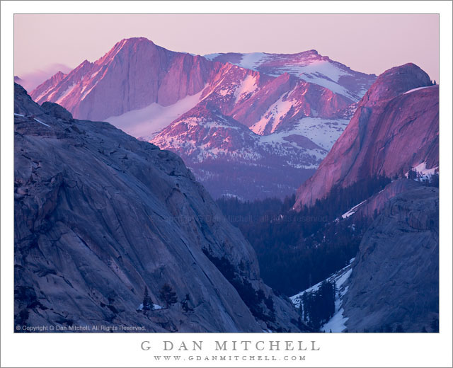
Tag Archives: crest

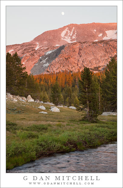
Sunset and Moonrise, Kuna Crest

Sunset and Moonrise, Kuna Crest

Sunset and Moonrise, Kuna Crest. Yosemite National Park, California. August 10, 2010. © Copyright 2011 G Dan Mitchell – all rights reserved.

The nearly- full moon rises above the sunset light on Kuna Crest, Yosemite National Park.

Kuna Crest runs up Lyell Canyon between the Lyell and Dana forks of the Tuolumne River with the Sierra crest at one end and Mammoth Peak at the other. (Mammoth Peak is the large peak straight in front of you as you top Tioga Pass entering Yosemite National Park.) This ridge can catch great sunset light during the summer, and as I came down from the pass, heading back toward my camp at Porcupine Flat, and saw the almost full moon appearing over the shoulder of the ridge I decided to quickly stop and make a few exposures as the last light was about to leave the forest and soon after the peaks.

If you have tried photographing a scene that includes the moon in the early evening you know that the exposure is a tricky thing. The moon is lit by daylight, so it isn’t too surprising that the “correct” exposure for the moon is close to a normal daytime exposure. But that is not the right exposure for the rest of the scene, which turns out to be quite a bit darker than daylight at this time of day. In this scene things were even more complicates as the very saturated red colors on the ridge were quite “hot,” while the foreground meadow and forest was in shade and both darker and cooler in color. Basically, the dynamic range between the moon and the foreground was too large for a single exposure… so I made several.

At the time of exposure I thought that I might need as many as three component images in the final photograph – they would be one exposed for the bright ridge and sky, one exposed for the rather dark and shadowed foreground, and possibly a third that correctly exposed the moon. To be on the safe side I bracketed four exposures. When I began to work on the image I figured out that in this case I could construct a final “believable” image from two exposures if I was careful and could make some additional adjustments during post.

This is an example of a shot in which the use of a graduated neutral density filter could have been problematic, but where exposure blending could work very well. (“Exposure blending” is one term for the process of manually combining two component exposures using masked layers in Photoshop. No, it is not the same thing as HDR photography.) One of the things that would have been quite tricking using graduated neutral density filters is that the division between the brighter upper half and the darker lower half is not linear. Instead, the roughly follows the curved boundary between the lower meadow and dark trees and the still sunlit trees and the peak and sky.

G Dan Mitchell Photography
About | Flickr | Twitter | FacebookGoogle+ | 500px.com | LinkedIn | Email

Text, photographs, and other media are © Copyright G Dan Mitchell (or others when indicated) and are not in the public domain and may not be used on websites, blogs, or in other media without advance permission from G Dan Mitchell.

(Basic EXIF data may be available by “mousing over” large images in posts. Leave a comment if you want to know more.)

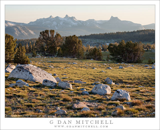
Gaylor Basin and the Cathedral Range, Evening

Gaylor Basin and the Cathedral Range, Evening

Gaylor Basin and the Cathedral Range, Evening. Yosemite National Park, California. July 26, 2011. © Copyright 2011 G Dan Mitchell – all rights reserved.

Evening shadows stretch across the boulder-filled meadows and forests of Gaylor Basin with the peaks of the Cathedral Range on the skyline, Yosemite National Park.

On the first evening of my late-July four-day visit to Yosemite’s high country along Tioga Pass Road I decided to visit this favorite location of mine. It is a short (but steep!) hike from near Tioga Pass over a nearby ridge to reach this quiet basin with its many lakes, long distance views of the Cathedral Range, and the treeline terrain of rocks and trees that I believe is my very favorite in the Sierra.

I started out after my mid-afternoon “dinner” and the drive to the trailhead from my camp at Porcupine Flat. Probably because it was so late in the day, I met a fair number of people hiking back out but only saw two others in the entire basin once I arrived. I suppose this is one of the advantages of keeping odd “photographer’s hours” – while most people are heading back to camp to fix dinner, I’m heading out to catch the evening light.

In the end, I didn’t make many photographs on this evening. I mostly wandered, something I love to do in these high open basins. I walked around the first lake, passing over some still-unmelted snow, and crossed the very full outlet stream, trying to skirt the wettest portions of the meadow by looking for rocky terrain. I finally settled on an area just below the lake and made a few photographs of trees and rocks and the long, shallow valley leading toward the main trunk of the Tuolumne River and the mountains beyond. I finished just after dusk, climbed back up the ridge as darkness came on, and finished the hike back to my car with the help of the light from my headlamp.

G Dan Mitchell Photography
About | Flickr | Twitter | FacebookGoogle+ | 500px.com | LinkedIn | Email

Text, photographs, and other media are © Copyright G Dan Mitchell (or others when indicated) and are not in the public domain and may not be used on websites, blogs, or in other media without advance permission from G Dan Mitchell.

(Basic EXIF data may be available by “mousing over” large images in posts. Leave a comment if you want to know more.)
Last Light, Mount Conness

Last Light, Mount Conness

Last Light, Mount Conness. Yosemite National Park, California. June 18, 2011. © Copyright G Dan Mitchell – all rights reserved.

The final evening alpenglow illuminates the summit ridge of Mount Conness and the west face of Medlicott Dome in the Yosemite National Park high country.

This will be my final photograph of Mount Conness from the evening of June 18, the day that Tioga Pass Road opened this year and the day of one of the most spectacular Yosemite high country sunsets in recent memory. It will be the final both in the sense that I think I’ve now shared the best of the group of images of this sunset and in the sense that it was literally my final exposure of the evening.

The short back-story is that what started out as a fairly unimpressive evening (at least in the photographic sense) transformed over a short period into something extraordinary as the sun dropped to the horizon west of the Sierra and illuminated the clouds from below, creating rare and very special alpenglow conditions over a wide area of the Sierra. (During the week that followed quite a few people commented on this amazing light, which they had witnessed from locations as distant as Mono Lake on the east side and the Central Valley to the west.)

When I made this photograph the show was coming to an end. At this point the sun had already set a few minutes earlier – the exposure was made around 8:45 p.m. – and the light was low enough to require a six-second exposure. While it may seem like Mount Conness (the tallest peak near the left on the skyline) and other features are receiving direct sunlight, this is actually the remaining post-sunset glow in the western sky.

G Dan Mitchell Photography
Flickr | Twitter (follow me) | Facebook (“Like” my page) | 500px.com | LinkedIn | Email

Text, photographs, and other media are © Copyright G Dan Mitchell (or others when indicated) and are not in the public domain and may not be used on websites, blogs, or in other media without advance permission from G Dan Mitchell.

Mammoth Peak and Kuna Crest, Overflowing Tuolumne River

Mammoth Peak and Kuna Crest, Overflowing Tuolumne River

Mammoth Peak and Kuna Crest, Overflowing Tuolumne River. Yosemite National Park, California. June 19, 2011. © Copyright G Dan Mitchell – all rights reserved.

Mammoth Peak and the Kuna Crest loom above as the Tuolumne River overflows its banks and floods surrounding meadows on a frosty spring morning, Yosemite National Park.

As I drove from Lee Vining Canyon over Tioga Pass and toward the Tenaya Lake area early in the morning, I came to the Tuolumne River where it passes under the bridge beneath the highway in the Tuolumne Meadows area. Just at about this moment the sun was rising high enough to begin to warm the frost covered meadow, at least the parts of it that were not flooded by the high water of the Tuolumne. Overnight it had risen almost to the level of the bridge and was so high that after passing under the bridge a small portion split off and headed into the trees to the right of the main branch. In a few weeks this flooded area and its reflecting surface will be gone, and there will just be a meadow and people will hike though it.

The backlight comes across the shoulder of Mammoth Peak, the high point near the end of the long snow-covered ridge of Kuna Crest, which runs parallel to Lyell Canyon toward Donohue Pass and the Sierra Crest.

G Dan Mitchell Photography | Flickr | Twitter (follow me) | Facebook (“Like” my page) | LinkedIn | Email
Text, photographs, and other media are © Copyright G Dan Mitchell (or others when indicated) and are not in the public domain and may not be used on websites, blogs, or in other media without advance permission from G Dan Mitchell.