Tag Archives: death

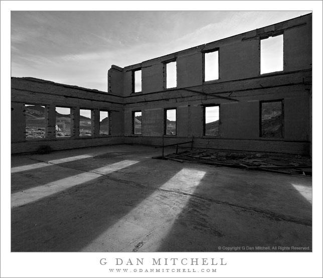
Schoolhouse Ruins, Rhyolite

Schoolhouse Ruins, Rhyolite

Schoolhouse Ruins, Rhyolite. Rhyolite, Nevada. April 1, 2009 © Copyright 2009 G Dan Mitchell – all rights reserved.

Morning sunlight shine through the window frames of the ruins of the abandoned schoolhouse in the ghost town of Rhyolite Nevada, near Death Valley National Park.

The ghost town of Rhyolite, Nevada is located just east of the boundary of Death Valley National Park, along the edge of the Amargosa Valley, and not far from Beatty, Nevada, which itself is close to the Nevada Test Site. Put all of that together and you have the potential for a bit of a spooky place!

Rhyolite was a short-lived mining town in the early 1900s, when it apparently was home to thousands of people who streamed to this forsaken landscape to find silver. The town was eventually abandoned – although some mining still takes place in the area – but a good number of the larger buildings are still there, in various states of decay. An old train station that looks pretty fancy is fenced off to keep us out, but you can walk (respectfully and carefully!) among many other old structures including the old school house that is the subject of this photograph.

I’ve been out here a number of times and dawn is my favorite time to photograph here. The light makes it to many of the old ruins very shortly after actual sunrise, and there is a moment of often beautiful light at this time. From Rhyolite the hills inside Death Valley National Park are visible to the west and above the nearer hills you can see Telescope Peak, the highest point in the park at over 11,000′ elevation.

The school (like a few of the other ruins) looks like it must have been a very large and robust structure. Even though the roof and the second floor are gone, almost all of the exterior walls still stand and don’t show any immediate signs of incipient collapse. On this morning I made a series of photographs from just inside one of the “doorways” of the school with a wide-angle lens. I selected and shared a few of them back in 2009, but I recently went back to my original raw files and decided to try this one in black and white.

G Dan Mitchell Photography
About | Flickr | Twitter | FacebookGoogle+ | 500px.com | LinkedIn | Email

Text, photographs, and other media are © Copyright G Dan Mitchell (or others when indicated) and are not in the public domain and may not be used on websites, blogs, or in other media without advance permission from G Dan Mitchell.

(Basic EXIF data may be available by “mousing over” large images in posts when this page is viewed on the web. Leave a comment if you want to know more.)

Eroded Gullies at Zabriskie Point, Morning

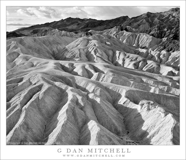
Eroded Gullies at Zabriskie Point, Morning

Eroded Gullies at Zabriskie Point, Morning. Death Valley National Park, California. April 6, 2006. © Copyright 2011 G Dan Mitchell – all rights reserved.

Low angle morning light illuminates a tortured landscape of eroded gullies at Zabriskie Point, Death Valley National Park.

I recently “rediscovered” this photograph while undertaking a major review of the past eight years of my raw files. (And, yes, that task is just about as much fun as you might imagine. It would actually be pretty unbearable except that every so often I find some photographs that I had perhaps forgotten or overlooked, and I also come across images that remind me of experiences that took place some time ago.)

This photograph was made, as virtually anyone who has visited the spot recognizes, by pointing my camera about 90 degrees to the left of the classic Zabriskie Point views. Timing was important, as the early light is just skimming across the tops of these tortuously eroded gullies, picking out the ridges between them but leaving the lower sections in shadow. But good fortune also played a role here. Death Valley is usually a clear blue sky kind of place, but on this morning I had clouds! At dawn, if I recall correctly, the clouds actually interfered with the light a bit. But as the sun rose the clouds provided a more dramatic background than plain blue sky and created some softer and diffused light that gave just the right sort of dynamic range for photographs.

On a technical note, if you are viewing this in the right web browser you can mouse over the image and see a summary of basic EXIF data. (Sorry, but this feature only works in web browsers – if you are viewing email, etc. you’ll need to visit the version at my blog to see the EXIF.) If you do check the EXIF you might notice that this photograph was made with a very humble example of photographic technology, the Canon Digital Rebel XT. This camera is a 8MP cropped sensor “consumer” camera that I acquired when I first tested the waters of DSLR photography. (I had actually used digital cameras back in the 1990s, but not for serious photographic work.) Those who wonder which of today’s current DSLRs might enable them to produce interesting and effective images might consider what could be done with such a humble camera. ;-)

G Dan Mitchell Photography
About | Flickr | Twitter | FacebookGoogle+ | 500px.com | LinkedIn | Email

Text, photographs, and other media are © Copyright G Dan Mitchell (or others when indicated) and are not in the public domain and may not be used on websites, blogs, or in other media without advance permission from G Dan Mitchell.

(Basic EXIF data may be available by “mousing over” large images in posts. Leave a comment if you want to know more.)
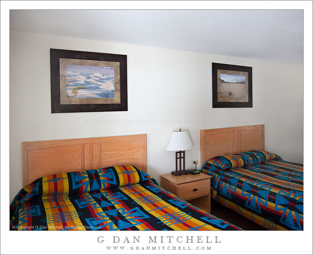
G Dan Mitchell Photographs at Stovepipe Wells

G Dan Mitchell Photographs, Stovepipe Wells Lodge

Stovepipe Wells Lodge – G Dan Mitchell photographs. Death Valley National Park, California. © Copyright G Dan Mitchell – all rights reserved.

Since several people have asked, I thought I would share an update on installation of my photographs at the historic Stovepipe Wells Lodge in Death Valley National Park. Late last year Ortega Family Enterprises (who also sell some of my photographs at Muir Woods National Monument) contacted me. They were about to take over the management of the facility from the previous concessionaire and were interested in selling some of my Death Valley photographs in the gift shop at Stovepipe Wells.

It turns out that they were also planning some significant upgrades to the lodging facilities at Stovepipe and they asked if I could provide a large number of 16″ x 24″ prints for the guest rooms. To make a long story short, they selected a half dozen of my Death Valley photographs and I went to work making nearly 170 prints of the six photographs, which were then shipped off to their framer for final preparation.

I finally got a chance to see the results when I visited Death Vally in early April. I stopped by and found out that they had begun the process of hanging the prints in guest rooms, and with the help of an employee I was able to get in long enough to snap a shot of one of the rooms. (Hanging in this room are Transverse Dunes, Death Valley and “Crossing Tracks, Racetrack Playa.”) It was also good to see some work being done to upgrade and update the lodge!

It is gratifying to have my photographs installed here for several reasons. Several of the photographs were made virtually within walking distance of Stovepipe Wells, where I often camp when I visit the Valley. I also know that among the many people who visit Stovepipe will be a good number of my fellow photographers – and knowing that they will see my prints here is both a bit intimidating and a quite exciting! Finally, before Ortega took over the facility I often stopped to look at some of the photographs and paintings that had been there previously. (I was glad to see that one wonderful black and white photograph was still hanging in the hotel office.) With that in mind, it seems like there is a good chance that these photographs of mine may be hanging in this historic facility for some time to come!

G Dan Mitchell Photography | Flickr | Twitter (follow me) | Facebook (“Like” my page) | LinkedIn | Email
Text, photographs, and other media are © Copyright G Dan Mitchell (or others when indicated) and are not in the public domain and may not be used on websites, blogs, or in other media without advance permission from G Dan Mitchell.

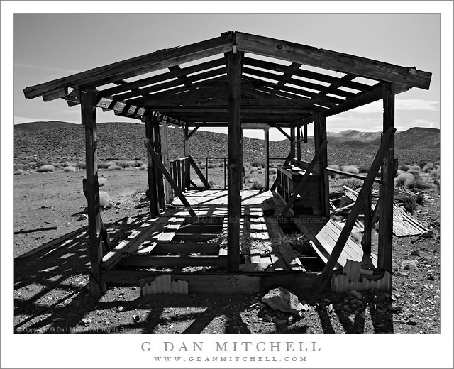
Abandoned Mining Cabin Ruins, Panamint Range

Abandoned Mining Cabin Ruins, Panamint Range

Abandoned Mining Cabin Ruins, Panamint Range. Death Valley National Park, California. March 29, 2011. © Copyright G Dan Mitchell – all rights reserved.

Black and white photograph of the ruins of an abandoned mining cabin high in the Panamint Mountain Range of Death Valley National Park.

There are a number of things that make Death Valley National Park, to the best of my knowledge, rather unique. One is the extensive history of human habitation inside the park boundaries, quite a bit of which is visible –  though some takes a bit more effort and attention to spot. The history of mining in the park is well-known, and many of the icons of the park have connections to this history. If you visit Furnace Creek, for example, you cannot miss the displays of old wagons and so forth used to move ore out of the Valley. It doesn’t take a lot of careful study to figure out that many park roads originated in an era of prospecting and mining. There are several well-known examples of structures left over from that era in and around the park, too.

It is largely because of this history that many areas of this national park are (or have been – some are now reverting to wilderness status) accessible by gravel road or four-wheel-drive routes. I would argue that you can’t really get to know this park if you just stick to the paved roads and the points of interest that they access. If you drive any of these other routes and keep your eyes open you will often be surprised by the left overs from relatively recent mining and prospecting, much of which isn’t really written about or described in the usual guides to the park. (And I’m not going to offer specific details about where to find such places here, since I don’t want to be even a little bit responsible for damage to them. If you do visit, treat them with care and respect.)

As I drove along a gravel road in one of the many mountain ranges of the park, returning from a site that is somewhat well-known, I began to notice evidence of fairly recent mining and prospecting. Faint tracks depart from the main “road” and cross valleys and hills, here and there tailing piles and mine entrances are visible, and sometimes you come across old structures such as cabins, storage bunkers, or wooden towers above mine entrances. I spotted the ruins of this old cabin above the road at one point and decided to walk up and investigate.

I’m almost always surprised at how “modern” many of the traces found at these places seem to be. I guess I am expecting something from the 1800s, but quite a few of these places look like they were build and occupied much later than that. I find modern things like linoleum flooring or modern-looking nails or electrical wire in many of them. There obviously isn’t much left of this cabin now, but from the detritus lying around near it and the form and materials found here, it must have been a reasonably comfortable place to live. As I walk around such places I often try to imagine what it must have been like to wake up every morning in this silent desert and head out for another day of physical labor.

G Dan Mitchell Photography | Flickr | Twitter (follow me) | Facebook (“Like” my page) | LinkedIn | Email
Text, photographs, and other media are © Copyright G Dan Mitchell (or others when indicated) and are not in the public domain and may not be used on websites, blogs, or in other media without advance permission from G Dan Mitchell.