Tag Archives: dirt

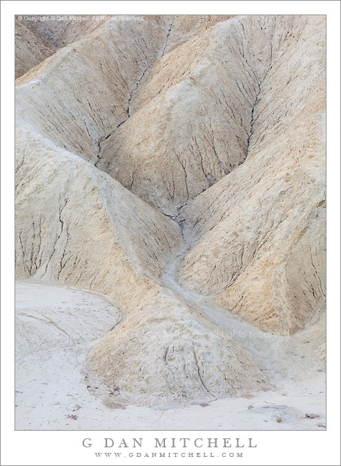
Edge of Gower Wash, Zabriskie Point

Edge of Gower Wash, Zabriskie Point

Edge of Gower Wash, Zabriskie Point. Death Valley National Park, California. April 30, 2010. © Copyright G Dan Mitchell – all rights reserved.

The folded hill and gully patterns along the edge of Gower Wash at Zabriskie Point, Death Valley National Park, California.

Having shot at Zabriskie Point often enough to feel less urgency about shooting the famous and iconic views… yet again… (unless conditions are truly exceptional), I’ve been looking for other elements in the scene. Last year I became interested in using very long lenses to isolate interesting small sections of the scene. I have to say that it is a lot more challenging and satisfying for me to look at the amazing number of potential subjects here that are not the justifiably famous images of Manley Beacon, the Panamints, and the panoramic view of Gower Wash. (I don’t want to get too full of myself here and make it sound like I’m “too good” to shoot the familiar views – in fact I still do point my camera in those directions when the light and other conditions are just right.)

This small section of cracked earth, small hills, and gullies sits right on the edge of the flatter and gravel-filled bottom of Gower Wash right below Zabriskie Point. I made this photograph early in the morning when the light of the sun was partially blocked by clouds to the east and I see a very subtle glow on the sides of these features that face east.

This photograph is not in the public domain and may not be used on websites, blogs, or in other media without advance permission from G Dan Mitchell.

G Dan Mitchell Photography | Twitter | Friendfeed | Facebook | Facebook Fan Page | Email

Technical Data:
Canon EOS 5D Mark II
Canon EF 100-400mm f/4.5-5.6 L IS USM at 190mm
ISO 200, f/11, 1/40 second

keywords: death, valley, national, park, california, usa, north america, spring, nature, zabriskie, point, morning, gower, wash, earth, dirt, gravel, sand, gully, hill, eroded, crack, landscape, scenic, travel, light, geology, stock

Detail, Zabriskie Point Formations

Detail, Zabriskie Point Formations

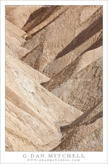
Detail, Zabriskie Point Formations. Death Valley National Park, California. March 29, 2010. © Copyright G Dan Mitchell – all rights reserved.

Detail photograph of patterns of barren hills and gullies at Zabriskie Point, Death Valley National Park, California.

From my series of detail photographs of smaller elements of the landscape at Zabriskie, and another one shot during atypical times of day – in this case in very bright afternoon sunshine. Because of these lighting conditions – color, intensity, and angle, the quality of the image is less “dreamy” than the typical early morning soft-light photographs of this area. Here you see more clearly the rough texture of the material making up the folds and gullies of these interesting hills that drop into Gower Gulch.

This photograph is not in the public domain and may not be used on websites, blogs, or in other media without advance permission from G Dan Mitchell.

G Dan Mitchell Photography | Twitter | Friendfeed | Facebook | Facebook Fan Page | Email

Technical Data:
Canon EOS 5D Mark II
Canon EF 100-400mm f/4.5-5.6 L IS USM at 330mm
ISO 100, f/16, 1/50 second

keywords: zabriskie, point, detail, hills, gullies, barren, dry, earth, dirt, afternoon, light, diagonal, forms, abstract, geology, nature, landscape, patterns, death valley, national park, scenic, travel, california, usa, north america, stock, eroded

Sunlit Gully, Zabriskie Point

Sunlit Gully, Zabriskie Point

Sunlit Gully, Zabriskie Point. Death Valley National Park, California. March 29, 2010. © Copyright G Dan Mitchell – all rights reserved.

Photograph of a sunlit gully in afternoon light at Zabriskie Point, Death Valley National Park, California.

Zabriskie Point is a justifiably famous overlook in Death Valley National Park – arguably the iconic view of the park, with the pyramid-shaped Manley Point above amazingly folder patterns of hills and gullies and with Death Valley and the sometimes snow topped summit of the Panamint Range beyond. (OK, the dunes might compete with Zabriskie in the Icon department…)

Everyone photographs at Zabriskie, and I’m no exception. However, my approach to this location has changed over time. At first any Zabriskie sunrise seems worth photographing, and in all honesty sunrise there is an amazing experience in all but the worst conditions. Eventually, though, you become a bit more discerning and not just any sunrise will do. I’ll generally only shoot sunrise there now if I think that the conditions will be extra spectacular, usually meaning some combination of clear or otherwise interesting lower atmosphere, perhaps snow on the Panamints, and some interesting clouds overhead. But even that is starting to feel a bit overworked.

Recently I’ve been trying to figure out what (and how) to photograph here without doing “the usual thing.” Several ideas have come to mind. Earlier I posted a photograph of the Manifold formation made at night under a full moon, and I think there is still more potential there. As others have done, I’ve played around with trying to find shooting locations other than the familiar one near the overlook. This photograph is an attempt to combine two other approaches that I’m working on – detail shots of small elements of the scene made with a long lens and shots made during the day at times other than the “normal” sunrise time.

I first saw this small gully a couple years ago when I happened to stop at Zabriskie during the mid-morning period on my way back from shooting somewhere else. Initially I just thought I’d wander up the path from the parking lot, scout things out a bit, and move on. But as I looked at the scene I realized that not all parts of this spot are necessarily best lit at sunrise, and that some actually can become interesting during the less obvious times of day. This is one attempt at a further exploration of this particular twisting gully, here shot in very bright daytime sun light only slightly diffused by high thin clouds.

This photograph is not in the public domain and may not be used on websites, blogs, or in other media without advance permission from G Dan Mitchell.

G Dan Mitchell Photography | Twitter | Friendfeed | Facebook | Facebook Fan Page | Email

Technical Data:
Canon EOS 5D Mark II
Canon EF 100-400mm f/4.5-5.6 L IS USM at 400mm
ISO 100, f/16, 1/125 second

keywords: zabriskie, point, fold, gully, hill, pattern, light, shadow, ridge, brown, golden, wash, rugged, gravel, dirt, geology, landscape, nature, scenic, travel, death valley, national, park, california, usa, north america, desert, formation, afternoon, winding, stock

Burn Zone, Near Foresta

Burn Zone, Near Foresta

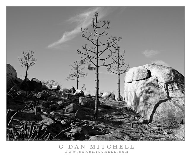
Burn Zone, Near Foresta. Yosemite National Park, California. October 31, 2009. © Copyright G Dan Mitchell – all rights reserved.

Trees, stumps, and boulders in a recently burned area near Foresta, Yosemite National Park, California.

The story behind this photograph is a sad one, and one that provokes a certain amount of anger. The small village of Foresta is just on the western boundary of Yosemite National Park, above El Portal and below the road into Yosemite Valley from the highway 120 northern park entrance. A number of years ago – seems like perhaps 15 or so, though I haven’t looked it up – a tremendous fire started near Foresta and burned quickly and very destructively through a mature forest that had gone too long without burning. Because of the build-up of litter on the forest floor, the fire burned unusually hot and not only consumed small trees and low-lying plants but also destroyed a complete mature forest between Foresta and Tioga Pass Road where it finally was stopped.

This was one of the fires that probably made clear the terrible risks forests were facing due to many years of fire suppression – these forests evolved in a world of periodic fires and smaller fires to clear out the undergrowth the inevitable big fire has so much fuel to feed upon that the damage to the forest is ultimately much worse. For this reason, Yosemite (along with other parks) has adopted a wise policy of letting natural fires burn out on their own. Personnel are dispatched to keep an eye on the fire and to ensure that it doesn’t get out of control or threaten people or structures, but otherwise the fires are allowed to burn naturally. The price of some additional late summer smoke is, I think, a small price to pay for a more healthy forest.

After that original fire, what had previously been a forest along this section of the road instead became an open area. At first many small plants and wildflowers took advantage of the sunlight and grew like crazy. Eventually larger trees began to grow and in the past few years it was almost possible to imagine that a forest like the original one might eventually return.

One day in August this past summer I was camped in the Ten Lake Basin to do photography. On the second to last day I decided to leave my base camp and instead plan a dry camp on top of a ridge above the Basin from which I had seen a tremendous panorama of the Sierra crest on my way in. I packed up, carrying extra water, and climbed the steep trail to the pass. But as I climbed I smelled smoke, and as I came to the summit I saw a plume of forest fire smoke to the west… in the direction of Foresta. I gave up on the photography and hiked on out. I eventually found out that NPS personnel had been conducting a “management fire” near Foresta (on a very hot and dry summer day!) when it got out of control. This “little fire” burned right out of the Foresta area and into the surrounding hills and valleys, eventually consuming thousands of acres… including a good portion of the area of the previous fire that had slowly been starting to recover.

The tragedies of this fire are several. First, it is troubling that those in charge of actions designed to lessen fire damage to the forest miscalculated so badly that they ended up destroying substantial areas of the forest they were to protect. Even worse, the recovery of this area has now been set back by years, and perhaps decades.

This photograph is not in the public domain and may not be used on websites, blogs, or in other media without advance permission from G Dan Mitchell.

G Dan Mitchell Photography | Gallery | Twitter | Friendfeed | Facebook | Facebook Fan Page | Email

keywords: yosemite, national, park, valley, sierra, nevada, mountain, range, autumn, fall, season, scenic, travel, nature, landscape, california, wildfire, burn, zone, ash, boulder, rock, stump, tree, dead, sky, cloud, dirt, branch, forest, fire, foresta, nature, black and white, shadow, ecology, stock, desolation