
Tag Archives: formation

Devil’s Cornfield

Devil's Cornfield
Devil’s Cornfield

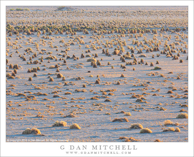
Devil’s Cornfield. Death Valley National Park, California. March 31, 2011. © Copyright 2013 G Dan Mitchell – all rights reserved.

Early morning light slants across the arrow weed plants of the Devil’s Cornfield area of Death Valley National Park

For the record, while I have no evidence either way regarding the role of the devil in creating this terrain, there is definitely no corn growing in this field! The plant is known as “arrowweed” (or arroweed or arrow weed), and the tall shapes are apparently formed as the sand erodes from around the roots.

This spot is one of several in Death Valley that have been hard for me to see as photographs. (Other “challenges” include the Devil’s Golf Course – which mostly looks like crusty, dried mud to me – and Salt Creek – which I’ve mostly visited at the times of day when the light hasn’t been idea.) I came close once before with a closer view of the plants that revealed their actual color a bit more and which placed them in front of a backdrop of more distant barren mountains. This photograph certainly doesn’t provide a strong center of visual interest, but I like the sense of the plants leading off into the distance, the angles of the blue shadows, and the contrasting warm colors of the plants in near golden-hour light.

G Dan Mitchell is a California photographer and visual opportunist whose subjects include the Pacific coast, redwood forests, central California oak/grasslands, the Sierra Nevada, California deserts, urban landscapes, night photography, and more.
Blog | About | Flickr | Twitter | FacebookGoogle+ | 500px.com | LinkedIn | Email

Text, photographs, and other media are © Copyright G Dan Mitchell (or others when indicated) and are not in the public domain and may not be used on websites, blogs, or in other media without advance permission from G Dan Mitchell.
Sandstone Tower, Fruita District

Sandstone Tower, Fruita District

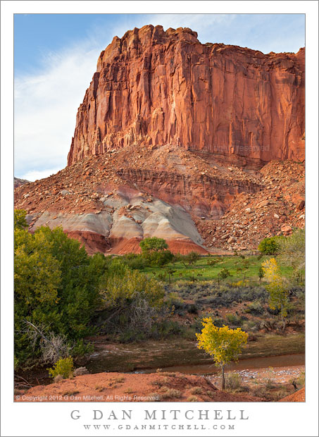
Sandstone Tower, Fruita District. Capitol Reef National Park, Utah. October 8, 2012. © Copyright 2012 G Dan Mitchell – all rights reserved.

A sandstone tower stands above the Fruita District orchards in early evening light, Capitol Reef National Park

These sandstone plateaus and mesas seem characteristic of this front-country area of Capitol Reef National Park, and they are perhaps the most striking visual icon of your approach to the park from the town of Torrey, Utah, to the west. The Fruita District is the most accessible area of the park, being right alongside the main east-west highway that passes through the park. It features some picturesque sites and sights that are enough to make almost anyone pull over and look, including the old orchards that apparently gave the area its name and the accessible petroglyphs on low cliffs that run along the road. (Although this portion of the park is quite accessible once you are out here and driving across Utah, most of the park is anything but easily accessible, and getting to other places within its boundaries can involve some very long drives on some fairly bad roads, plus some hiking. I’m fine with that! ;-)

I made this photograph late in the day, after we had done a bit of exploring along the main tourist route into the park, the largely paved road towards Capitol Gorge and other nearby points. Late in the day I happened to spot this little conjunction of creek and fall-color tree and green grass and red rock cliffs as we were about to leave the park.

G Dan Mitchell is a California photographer and visual opportunist whose subjects include the Pacific coast, redwood forests, central California oak/grasslands, the Sierra Nevada, California deserts, urban landscapes, night photography, and more.
Blog | About | Flickr | Twitter | FacebookGoogle+ | 500px.com | LinkedIn | Email

Text, photographs, and other media are © Copyright G Dan Mitchell (or others when indicated) and are not in the public domain and may not be used on websites, blogs, or in other media without advance permission from G Dan Mitchell.
Fiery Furnace, Arches National Park

Fiery Furnace, Arches National Park

Fiery Furnace, Arches National Park. Arches National Park, Utah. October 11, 2012. © Copyright 2012 G Dan Mitchell – all rights reserved.

Ridges and mesas recede into the distance beyond Fiery Furnace formations, Arches National Park.

These formations are part of a much larger set of similar structures along the road toward the Devil’s Garden area of Arches National Park. They overlook a large section of the park and beyond. The distant plateau in the sunlight is along the Colorado River, and though they are not visible in this photograph the La Sal Mountains tower even further off. Between there is a lot of rough country full of valleys and ridges and other formations.

The Fiery Furnace area contains sandstone with layers of contrasting color, as see here. This material has been eroded it all sorts of fantastical ways. On this particular day, the light conditions were both interesting and challenging. There were quite a few high clouds and a good portion of the time the sun was blocked by them and the light was somewhat dismal. But as the clouds moved along, the sun light occasionally broke through gaps and cast beams of light that traversed the landscape. When we first stopped here and saw the overcast conditions I almost decided to just move on. But I saw a few hints of this changeable light and decided to try patience first! It took a while, but eventually some of the clear areas in the overcast lined up with our position and we had moments of nice light.

G Dan Mitchell is a California photographer and visual opportunist whose subjects include the Pacific coast, redwood forests, central California oak/grasslands, the Sierra Nevada, California deserts, urban landscapes, night photography, and more.
Blog | About | Flickr | Twitter | FacebookGoogle+ | 500px.com | LinkedIn | Email

Text, photographs, and other media are © Copyright G Dan Mitchell (or others when indicated) and are not in the public domain and may not be used on websites, blogs, or in other media without advance permission from G Dan Mitchell.

Ledge With Fallen Rocks

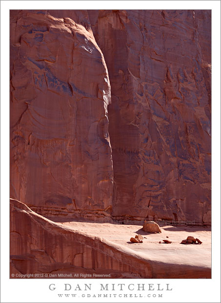
Ledge With Fallen Rocks - Red cliffs and rocks on a ledge at Park Avenue, Arches National Park
Red cliffs and rocks on a ledge at Park Avenue, Arches National Park

Ledge With Fallen Rocks. Arches National Monument, Utah. April 6, 2012. © Copyright 2012 G Dan Mitchell – all rights reserved.

Red cliffs and rocks on a ledge at Park Avenue, Arches National Park.

I made this photograph fairly early in the morning at the Park Avenue area of Arches National Park. While morning might was hitting the walls behind my camera position, the walls in front of me were still in fairly deep shade. However, as the sun rose, its light began to come over the tops of these tall sandstone walls and spill down into the canyon. As the morning wore on, the light/shadow line began to move back closer to this wall, first illuminating the ledge and the fallen rocks in holds and then beginning to highlight edges of some of the cracks in the wall itself.

The Park Avenue area seems like one of the most accessible areas of this park being only a short distance inside the park boundaries and being very close to the roadway. The area is essentially a canyon between two nearly parallel walls of sandstone, often topped with remarkable towers and other features as the canyon descends toward where it opens up into sage brush country below. At this particular hour of this particular morning, as wonderful as that scene was, the light shooting down the canyon was only so-so, so I looked around, put on a long lens, and photographed smaller vignettes of the landscape such as this one.

G Dan Mitchell is a California photographer whose subjects include the Pacific coast, redwood forests, central California oak/grasslands, the Sierra Nevada, California deserts, urban landscapes, night photography, and more.
Blog | About | Flickr | Twitter | FacebookGoogle+ | 500px.com | LinkedIn | Email

Text, photographs, and other media are © Copyright G Dan Mitchell (or others when indicated) and are not in the public domain and may not be used on websites, blogs, or in other media without advance permission from G Dan Mitchell.