
Tag Archives: landscape

Whitewater, Tenaya Creek

Whitewater, Tenaya Creek

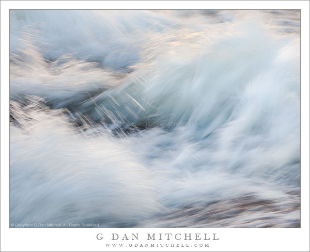
Whitewater, Tenaya Creek. Yosemite National Park, California.June 28, 2010. © Copyright G Dan Mitchell – all rights reserved.

Turbulent whitewater flows through an area of steep granite along Tenaya Creek, Yosemite National Park.

You can, of course, find a place to shoot subjects like this one all over the Sierra and no doubt in many other places as well. This photograph was made during a period of relatively high water early in the season and in a spot where the water flowed over some rocks in shade. Sunlight on the other side of the stream reflected into the water and revealed highlights, especially the flying spray that I allowed to blur with a somewhat slow shutter speed.

The moving water in Sierra streams and rivers seems to be an almost irresistible subject for many photographers, and I confess that I count myself among them. In some ways it is almost too easy to make these photographs, and one basic requirement is a willingness to make quite a few exposures. The instantaneous motion of the water and the reflections of light simply cannot be controlled or predicted, so one almost has to make many, many exposures. Of course, there is a bit more to it than pointing the camera at water and then repeatedly pressing the shutter release. It is important to find some sort of compositional interest first – it could be where water flows around or over a rock, a place where the light catches the water, or possibly just the twisting forms of turbulent water. Light is extra important in these photographs I think – most often the colors come from a combination of the blue-green shades of water full of foam and from reflected light from things that are out of the frame. (In this photograph, the light mostly comes from sunlight reflected off of granite on the far side of the stream.) Shutter speed is an important consideration, as a short exposure will stop or nearly stop the water and freeze the motion, a somewhat longer exposure can hold some detail but still allow blur along the direction of the flow, and very long exposures can create a misty and diffuse effect.

G Dan Mitchell Photography | Flickr | Twitter | Facebook | Email
Text, photographs, and other media are © Copyright G Dan Mitchell (or others when indicated) and are not in the public domain and may not be used on websites, blogs, or in other media without advance permission from G Dan Mitchell.
Golden Gate and Bay Bridges, Morning Haze

Golden Gate and Bay Bridges, Morning Haze

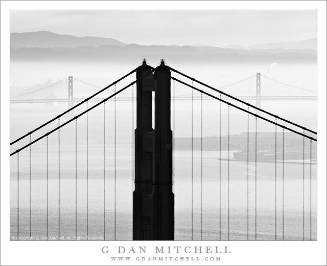
Golden Gate and Bay Bridges, Morning Haze. San Francisco Bay, California. February 5, 2011. © Copyright G Dan Mitchell – all rights reserved.

Black and white photograph of Golden Gate Bridge north tower, the San Francisco-Oakland Bay Bridge, and the East Bay Hills in morning haze.

I sometimes enjoy playing the juxtaposition game, going up into the Marin Headlands and using a long lens to juxtapose elements of the Golden Gate Bridge with other elements of the landscape, human and natural, of San Francisco Bay. One of the most iconic examples of such photographs is the one that many have shot (including me!) that centers the tip of the Transamerica building within a frame formed by the north tower of the bridge. But there are many other possibilities that might be at least as interesting, and which may depend more on the changing and often very interesting conditions of atmosphere and light over the bay.

This photograph was made from a point very close to that from which the Transamerica building photograph can be made, but a bit higher on the road up into the headlands. When I arrived just before dawn in the general area there were quite a few other photographers who I presume were there to photograph the dawn scene. (This is a difficult task, as it requires you to shoot essentially directly into the sun if you want San Francisco in your shot.) I was surprised when essentially all of the other photographers packed up and left a few minutes after the sun came up! (In their defense, it was windy up there – so windy that it made shooting with a long lens quite a challenge!) The sunrise wasn’t all that amazing, at least not if you know this area pretty well. But the low haze/fog over the east bay hills and some overhead clouds filtering the light a bit created the potential for some interesting and moody light – at least if I used a long lens to isolate small sections of the scene.

I’m almost a bit embarrassed to admit that I picked my first shooting location not based on the scene but rather on trying to avoid the wind! I went up the road to a spot where I could shoot in the lee of a hill side. After getting that out of my system, I went the other way and entered a very windy area along the road below the parking lot. I eventually found a spot that lined up the two great bridges of San Francisco Bay – the north tower of the Golden Gate Bridge in the foreground and two towers and a central span of the San Francisco-Oakland Bay Bridge in the distance, both backed by that low fog and haze and beyond the East Bay Hills.

G Dan Mitchell Photography | Flickr | Twitter | Facebook | Email
Text, photographs, and other media are © Copyright G Dan Mitchell (or others when indicated) and are not in the public domain and may not be used on websites, blogs, or in other media without advance permission from G Dan Mitchell.
Alcatraz, Treasure Island, East Bay Hills

Alcatraz, Treasure Island, East Bay Hills

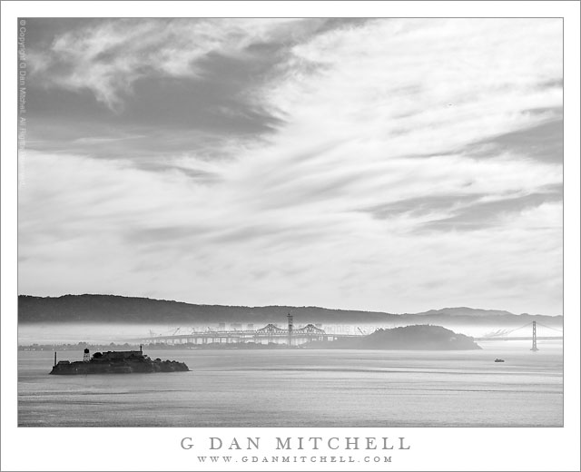
Alcatraz, Treasure Island, East Bay Hills. San Francisco Bay, California. February 5, 2011. © Copyright G Dan Mitchell – all rights reserved.

Black and white photograph of San Francisco Bay with Alcatraz, Treasure Island, and the East Bay Hills beneath a morning winter sky.

On this early February day the rough plan was to head up across the Golden Gate Bridge before dawn, shoot a bit from high in the Marin Headlands as the sun rose, and then continue on to most likely shoot at Muir Woods. However, I ended up spending at least two hours shooting from the headlands, and by the time I finished I knew that the tourist hordes would be arriving at Muir Woods, so I only did a bit of additional shooting from the hills before heading back home.

This photograph was made just before I left the Marin Headlands, near the last turn before the road crosses highway 101 near the Golden Gate. It is a familiar location and I’ve photographed from here many times in the past. I don’t always stop, but if something is a bit special or unusual about the conditions I will. That was the case today as someone unusual weather conditions had left the bay mostly clear, but with a thin layer of fog over Oakland and other areas along the east side of the San Francisco Bay – and impressive high clouds were floating above. Alcatraz Island is at the left, Treasure Island and the San Francisco-Oakland Bay Bridge are in the center, and beyond that the tops of buildings in downtown Oakland are visible against the backdrop of the East Bay hills.

G Dan Mitchell Photography | Flickr | Twitter | Facebook | Email
Text, photographs, and other media are © Copyright G Dan Mitchell (or others when indicated) and are not in the public domain and may not be used on websites, blogs, or in other media without advance permission from G Dan Mitchell.

Glacial Erratics and Trees, Lembert Dome

Glacial Erratics and Trees, Lembert Dome

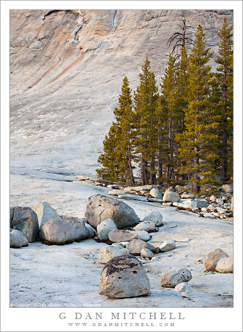
Glacial Erratics and Trees, Lembert Dome. Yosemite National Park, California. June 5, 2010. a© Copyright G Dan Mitchell – all rights reserved.

Glacial erratics and trees at the base of Lembert Dome, Tuolumne Meadows, Yosemite National Park.

This photograph was made last spring in early June, when I drove over Tioga Pass on a quick one-day jaunt right around the time that the road was re-opened for the season after its annual winter closure. The road opened a bit later than usual in 2010 due to above average and late snow fall, and when I crossed there was as much or more snow than I recall seeing up there.

This was one of my marathon drive days. I started well before dawn in the San Francisco Bay Area and arrived in Yosemite in the very early morning and without any concrete plan – except that the ideas of visiting waterfalls and possibly getting up to Tioga Pass were on my mind. I did stop near the Valley first, where I made a series of photographs of Cascade Creek in virtually full flow. After doing this and making a very brief visit to the Valley, I decided to visit the high country along Tioga Pass road. I went just over the pass before turning back. There was so much snow still around that in most places it still looked much more like winter than like early June.

I finally started heading back to the west, as my plan was to return late to the SF Bay Area. As I left the pass and started down toward Tuolumne Meadows the light began to get “interesting” as the sun dropped lower in the west and some high clouds occasionally softened the light. As I drove past Lembert Dome I thought of photographing these glacial erratics that sit on the apron at the bottom of the dome before making one last stop to photograph snow-covered Tuolumne Meadow in the day’s last light.

G Dan Mitchell Photography | Flickr | Twitter | Facebook | Email
Text, photographs, and other media are © Copyright G Dan Mitchell (or others when indicated) and are not in the public domain and may not be used on websites, blogs, or in other media without advance permission from G Dan Mitchell.