Tag Archives: panamint

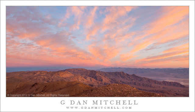
Dawn Sky, Panamint Range

Dawn Sky, Panamint Range

Dawn Sky, Panamint Range. Death Valley National Park, California. January 5, 2012. © Copyright 2012 G Dan Mitchell – all rights reserved.

First dawn light on clouds above Death Valley, as seen from high in the Panamint Range

I recently “discovered” (or perhaps “remembered?”) this photograph that I made nearly a year earlier during an early January 2012 trip to do winter photography in Death Valley National Park. Winter is a wonderful time in Death Valley, though the season can present its own challenges – not the same as summer, but challenges nonetheless. The challenges include, believe it or not, the possibility of some very, very cold weather, especially in some of the higher outlying areas of the park an up in the mountains, such as here in the Panamint Range. But there are special rewards, too, including the possibility of snow among the peaks and the more interesting skies that can come with the passage of winter low pressure systems that originate in the Pacific Ocean.

On this morning I had gotten out of my sleeping bag well before dawn so that I would have time to drive to this overlook high in the Panamints before sun rise. It was still dark as I drove the last section of the gravel road approach, and its wasn’t until after I arrived that there was enough light to see that this might turn out to be a spectacular sunrise. (When you get up in darkness and drive many miles, you have to take it on faith that something special might occur, and accept the possibility that it might not.) My original subject ideas for this location were not so much about sky as about deep valleys and receding ridges, but when the first sun hit these high clouds I was willing to angle the tripod up a bit to photograph them! This light on the clouds only lasted a few minutes, and after that I turned my attention back to the landscape below.

G Dan Mitchell is a California photographer and visual opportunist whose subjects include the Pacific coast, redwood forests, central California oak/grasslands, the Sierra Nevada, California deserts, urban landscapes, night photography, and more.
Blog | About | Flickr | Twitter | FacebookGoogle+ | 500px.com | LinkedIn | Email

Text, photographs, and other media are © Copyright G Dan Mitchell (or others when indicated) and are not in the public domain and may not be used on websites, blogs, or in other media without advance permission from G Dan Mitchell.

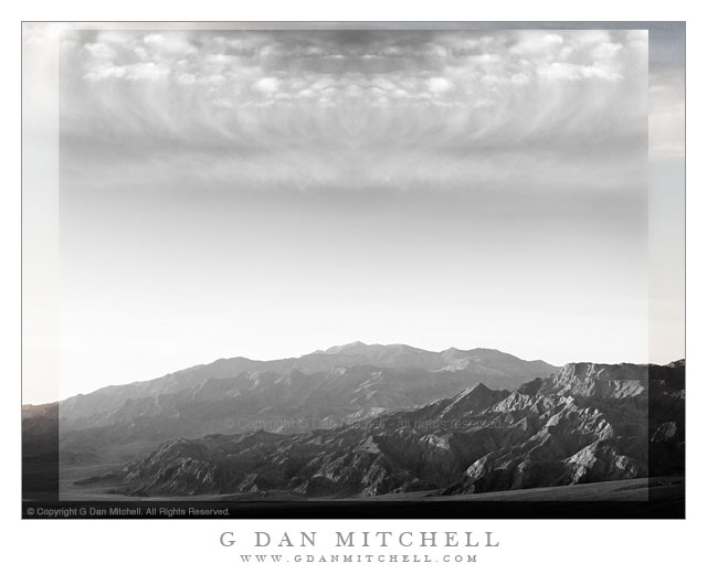
Imaginary Landscape – Death Valley

Imaginary Landscape - Death Valley - An imaginary landscape derived from subjects photographed in Death Valley National Park.
An imaginary landscape derived from subjects photographed in Death Valley National Park.

Imaginary Landscape – Death Valley. Photographic components from Death Valley, California. January 3, 2012. © Copyright 2012 G Dan Mitchell – all rights reserved.

An imaginary landscape derived from subjects photographed in Death Valley National Park.

“Imaginary Landscapes” are images most often derived from photographs of natural scenes and objects, but modified in ways that are not intended to be realistic.

While working on this photograph, I was experimenting with some techniques for post processing images, particularly to control the visibility of features at the very light and very dark ends of the luminosity scale. One thing led to the next, and soon I had darkened the sky, enhanced the dynamic range in the clouds, and tried a monochrome interpretation of the scene. Then I got the idea to play around a bit with the sky and clouds and before long things had progressed to a point that was well beyond believable.

G Dan Mitchell is a California photographer whose subjects include the Pacific coast, redwood forests, central California oak/grasslands, the Sierra Nevada, California deserts, urban landscapes, night photography, and more.
Blog | About | Flickr | Twitter | FacebookGoogle+ | 500px.com | LinkedIn | Email

Text, photographs, and other media are © Copyright G Dan Mitchell (or others when indicated) and are not in the public domain and may not be used on websites, blogs, or in other media without advance permission from G Dan Mitchell.
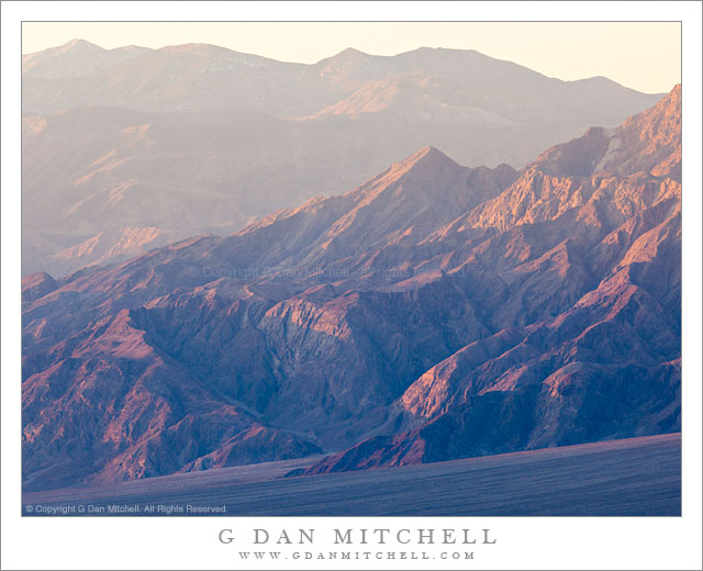
First Light, Base of Tucki Mountain and the Panamint Range

First Light, Base of Tucki Mountain and the Panamint Range - First morning light on the rugged landscape of the base of Tucki Mountain and the Panamint Range, Death Valley National Park, California
First morning light on the rugged landscape of the base of Tucki Mountain and the Panamint Range, Death Valley National Park, California

First Light, Base of Tucki Mountain and the Panamint Range. Death Valley National Park, California. January 3, 2012. © Copyright 2012 G Dan Mitchell – all rights reserved.

First morning light on the rugged landscape of the base of Tucki Mountain and the Panamint Range, Death Valley National Park, California

This photograph was made from a location a ways up from the bottom of Death Valley, from which I could look directly across at the lower slopes of gigantic Tucki Mountain as the first morning light worked its way down toward the lower ridges and the huge alluvial fan at the base of the mountain. At the moment I made the exposure the light was just beginning to fill this slanting area below the rugged mountains, and the light was softened by morning haze.

Tucki Mountain is a huge peak that almost seems to me to be large enough to count as its own minor mountain range. It rises above Stovepipe Wells, and extends a great distance east, south, and west of there. It is laced with deep canyons and its lower slopes are heavily eroded to reveal tilting and twisting strata. Another large valley lies on beyond the foreground spur ridge in this photograph, and beyond that the Panamint Range rises to its crest at 11,000+’ Telescope Peak.

G Dan Mitchell is a California photographer whose subjects include the Pacific coast, redwood forests, central California oak/grasslands, the Sierra Nevada, California deserts, urban landscapes, night photography, and more.
Blog | About | Flickr | Twitter | FacebookGoogle+ | 500px.com | LinkedIn | Email

Text, photographs, and other media are © Copyright G Dan Mitchell (or others when indicated) and are not in the public domain and may not be used on websites, blogs, or in other media without advance permission from G Dan Mitchell.
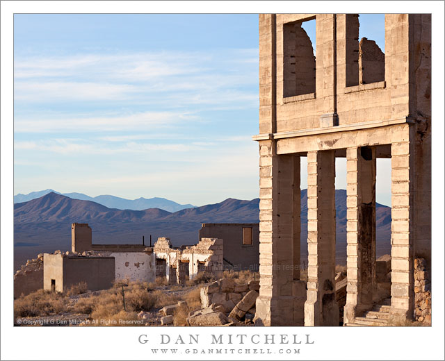
Rhyolite Ghost Town, Amargosa Valley and Mountains

Rhyolite Ghost Town, Amargosa Valley and Mountains - The ruins of the ghost town of Rhyolite, Nevada stand above the Amargosa Valley, with the Amargosa Range and Death Valley National Park in the distance.
The ruins of the ghost town of Rhyolite, Nevada stand above the Amargosa Valley, with the Amargosa Range and Death Valley National Park in the distance.

Rhyolite Ghost Town, Amargosa Valley and Mountains. Rhyolite, Nevada. January 4, 2012. © Copyright 2012 G Dan Mitchell – all rights reserved.

The ruins of the ghost town of Rhyolite, Nevada stand above the Amargosa Valley, with the Amargosa Range and Death Valley National Park in the distance.

While there can be some moments of beautiful and colorful sunrise light at the ghost town of Rhyolite, Nevada – and I was there for it – this early morning light from a short time later probably gives a more true sense of what the place tends to look like during the winter months. (Even here, the high, thin clouds soften the scene a bit – it is often quite cloudless.)

From what I understand, Rhyolite sprang up in the very early 1900s after gold was discovered nearby. During the short life of the town, measured in no more than decades, it was reportedly the second largest city in southern Nevada. It featured banks (two of which are seen in this photograph), a railroad station (abandoned but still present and located behind my camera position), newspapers, an impressive school house, and thousands of residents. It was all largely abandoned in the first half of the 1900s and most of the buildings are gone, though traces of them and the old roads they lined can still be found here and there. A few large buildings in the center of the town still more or less stand, in varying states of decay. The building on the right was the Cook Bank. Another bank was located where the white walls are a bit further in the distance. The town school house is the furthest building. The whole town overlooked the Amargosa Valley, where the current boundary of Death Valley National Park lies. Beyond that, an inside the park, are the Amargosa Range and in the far distance the ridge of the Panamint Range and the summit of 11,000+’ Telescope Peak.

G Dan Mitchell is a California photographer whose subjects include the Pacific coast, redwood forests, central California oak/grasslands, the Sierra Nevada, California deserts, urban landscapes, night photography, and more.
Blog | About | Flickr | Twitter | FacebookGoogle+ | 500px.com | LinkedIn | Email

Text, photographs, and other media are © Copyright G Dan Mitchell (or others when indicated) and are not in the public domain and may not be used on websites, blogs, or in other media without advance permission from G Dan Mitchell.