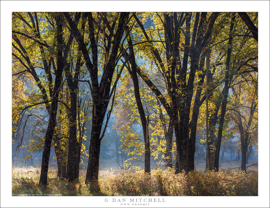
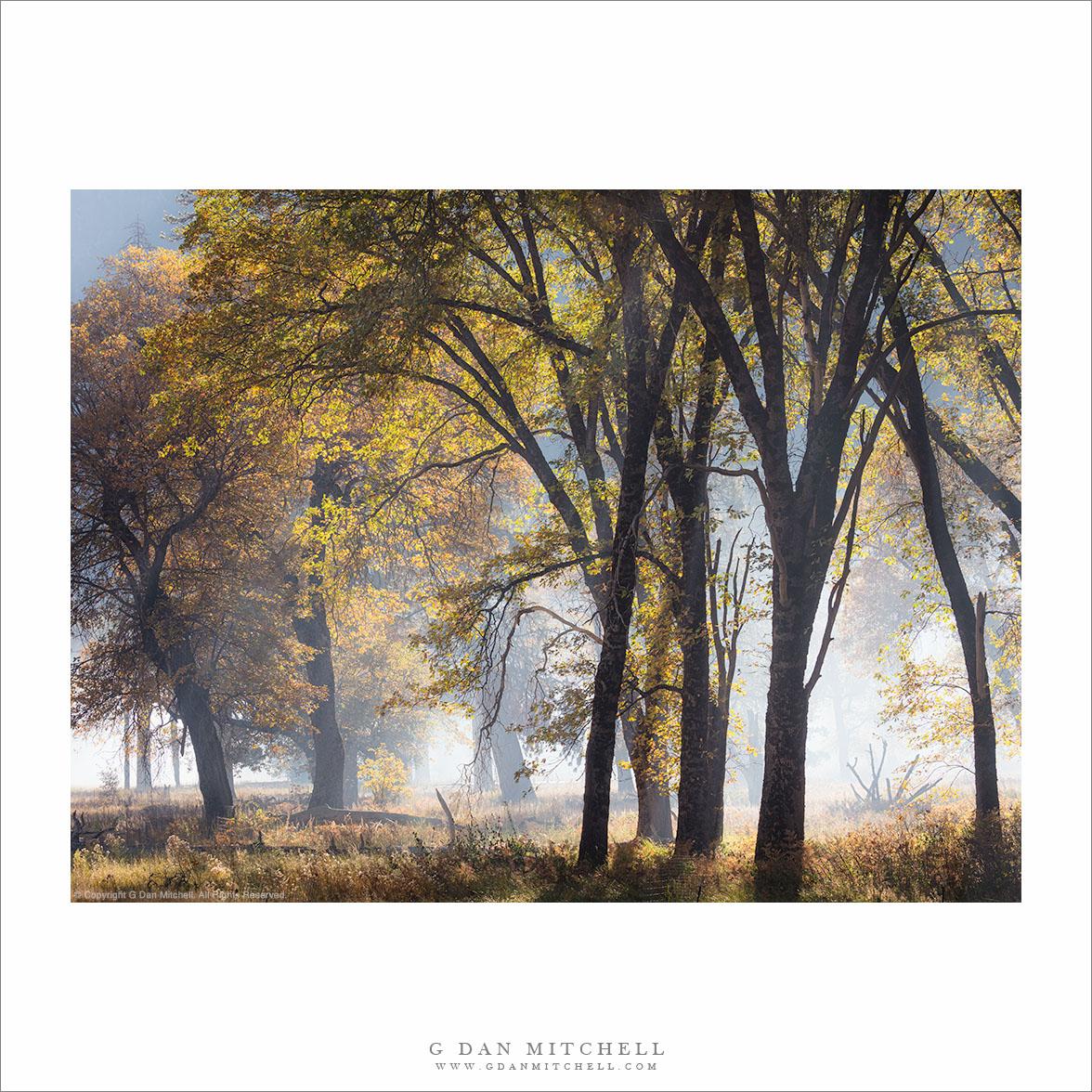
Tag Archives: management

Autumn Oaks, Morning

Autumn Oaks, Morning
Autumn oak trees silhouetted in morning light, against the backdrop of smoke from a managed fire, Yosemite Valley.

Autumn Oaks, Morning. © Copyright 2023 G Dan Mitchell.

Autumn oak trees silhouetted in morning light, against the backdrop of smoke from a managed fire, Yosemite Valley.

This photograph comes from the my November 1 visit to Yosemite Valley on a day when a managed fire filled the air with smoke. It was especially thick here, as the fire was burning more or less around the meadow containing these trees. In the photograph you can probably see the thicker smoke in the shaded distance, though where I was standing it was not quite as bad.

There were several key features making this photograph work. The slender trunks of these trees are always interesting, but here they were backlight by intense sunlight coming over the top of the Valley walls, increasing the saturation of the fall leaf color. This light also left the trunks in silhouette while lighting up some of the dry autumn grasses, and the smoke muted background distractions.


G Dan Mitchell is a California photographer and visual opportunist. His book, “California’s Fall Color: A Photographer’s Guide to Autumn in the Sierra” is available from Heyday Books, Amazon, and directly from G Dan Mitchell.

Blog | About | Twitter | Flickr | FacebookEmail

Links to Articles, Sales and Licensing, my Sierra Nevada Fall Color book, Contact Information.

Scroll down to leave a comment or question. (Click this post’s title first if you are viewing on the home page.)


All media © Copyright G Dan Mitchell and others as indicated. Any use requires advance permission from G Dan Mitchell.

Sandstone Patterns, Dried Plant

Sandstone Patterns, Dried Plant - A dried plant and sandstone patterns in a southwest desert canyon, Utah
A dried plant and sandstone patterns in a southwest desert canyon, Utah

Sandstone Patterns, Dried Plant. Grand Staircase-Escalante National Monument, Utah. October 23, 2012. © Copyright 2012 G Dan Mitchell – all rights reserved.

A dried plant and sandstone patterns in a southwest desert canyon, Utah

I was in Utah twice this fall, most recently with my friends Charlie and Karl to photograph a range of desert canyons and similar terrain. I’ve written before that I’m very new to photographing Utah, having seriously shot there for the first time only this past spring. But I’m trying to make up for lost time! Overall, I have spent something like a total of more than five weeks there this year! Yes, I like shooting in Utah. :-)

On the previous visits, I went to quite a few of the well-known locations – largely the national parks – and began the process of getting to know and understand that place a bit. On the most recent visit I was fortunate to be traveling with people who have shot there for decades, and I benefited from their long experience. Getting a bit more off the beaten track, we barely touched national parks – passing through Zion and visiting some remote areas of Capitol Reef. Instead we poked into a range of little canyons and valleys and so forth that don’t have the prominence of the parks. The specific locations are perhaps not that important since the state seems to be filled with similar places. This was my first real experience with the intimate desert canyons and river/creek courses that carve deeply into the landscape, where midday light bounces and reflects into the deep landscape in ways that are utterly unlike the California locations where I most often photograph.

This photograph was made in such a place, the first narrow canyon that we visited. Parking in an inauspicious spot along a gravel desert road, we dropped into a wash and wandered upstream, soon entering a narrow canyon as the sandstone walls rose beside us. Before long the canyon was narrow enough that we had to continually cross back and forth across the creek or simply wade straight up its course. As the canyon narrowed, direct sunlight no longer made it down to the creek – instead the light reflected from the higher cliff faces and bounced down into the canyon, toning the light red from the sandstone surface. In this photograph the cliff and two large pieces of sandstone contain angled strata and reflect the light in various ways as a small and seemingly dead plant sits in a crack in the rock.

G Dan Mitchell is a California photographer whose subjects include the Pacific coast, redwood forests, central California oak/grasslands, the Sierra Nevada, California deserts, urban landscapes, night photography, and more.
Blog | About | Flickr | Twitter | FacebookGoogle+ | 500px.com | LinkedIn | Email

Text, photographs, and other media are © Copyright G Dan Mitchell (or others when indicated) and are not in the public domain and may not be used on websites, blogs, or in other media without advance permission from G Dan Mitchell.

Rhyolite Ghost Town, Amargosa Valley and Mountains

Rhyolite Ghost Town, Amargosa Valley and Mountains - The ruins of the ghost town of Rhyolite, Nevada stand above the Amargosa Valley, with the Amargosa Range and Death Valley National Park in the distance.
The ruins of the ghost town of Rhyolite, Nevada stand above the Amargosa Valley, with the Amargosa Range and Death Valley National Park in the distance.

Rhyolite Ghost Town, Amargosa Valley and Mountains. Rhyolite, Nevada. January 4, 2012. © Copyright 2012 G Dan Mitchell – all rights reserved.

The ruins of the ghost town of Rhyolite, Nevada stand above the Amargosa Valley, with the Amargosa Range and Death Valley National Park in the distance.

While there can be some moments of beautiful and colorful sunrise light at the ghost town of Rhyolite, Nevada – and I was there for it – this early morning light from a short time later probably gives a more true sense of what the place tends to look like during the winter months. (Even here, the high, thin clouds soften the scene a bit – it is often quite cloudless.)

From what I understand, Rhyolite sprang up in the very early 1900s after gold was discovered nearby. During the short life of the town, measured in no more than decades, it was reportedly the second largest city in southern Nevada. It featured banks (two of which are seen in this photograph), a railroad station (abandoned but still present and located behind my camera position), newspapers, an impressive school house, and thousands of residents. It was all largely abandoned in the first half of the 1900s and most of the buildings are gone, though traces of them and the old roads they lined can still be found here and there. A few large buildings in the center of the town still more or less stand, in varying states of decay. The building on the right was the Cook Bank. Another bank was located where the white walls are a bit further in the distance. The town school house is the furthest building. The whole town overlooked the Amargosa Valley, where the current boundary of Death Valley National Park lies. Beyond that, an inside the park, are the Amargosa Range and in the far distance the ridge of the Panamint Range and the summit of 11,000+’ Telescope Peak.

G Dan Mitchell is a California photographer whose subjects include the Pacific coast, redwood forests, central California oak/grasslands, the Sierra Nevada, California deserts, urban landscapes, night photography, and more.
Blog | About | Flickr | Twitter | FacebookGoogle+ | 500px.com | LinkedIn | Email

Text, photographs, and other media are © Copyright G Dan Mitchell (or others when indicated) and are not in the public domain and may not be used on websites, blogs, or in other media without advance permission from G Dan Mitchell.