Tag Archives: sagebrush

Sagebrush and Aspens

Sagebrush and Aspens

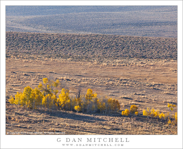
Sagebrush and Aspens. East of the Sierra Nevada, California. October 13, 2013. © Copyright 2013 G Dan Mitchell – all rights reserved.

Sparse, colorful aspen trees in the high sagebrush country east of the Sierra Nevada.

Back in October I made my annual trek to the east side of the Sierra Nevada to photograph autumn subjects, including but not limited to aspen trees in their fall colors. As often happens at this time of the year, we encountered a wide range of conditions ranging from beautiful sunny days to one day on which it snowed the entire time as we drove over the crest and down highway 395. Overall, this turned out to be a fine year for aspen color, though it was not exactly a typical year. The color came a bit early and seemed to change quickly in a number of areas. Even though many of us were concerned that the past two years of California drought – perhaps combined with the effects of global climate changes – might have reduced the colors, in the end the effect was simply to change the timing a bit. (And long time aspen photographers know that, in a sense, there really is no such thing as a “typical season” for aspen color.)

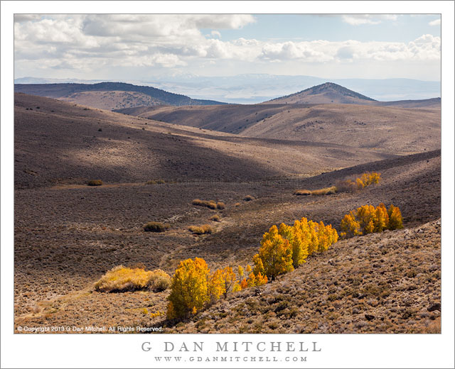
The final day of our five-day visit was a diverse one, and it took us to a range of quite different locations. It started in Mammoth Lakes, where we were surprised to find that it was snowing lightly when we left our motel in the pre-dawn darkness and headed out into Long Valley. After stopping there to photograph the morning snow flurries along the eastern Sierra, we continued to the east and drove all the way to Benton before turning around and heading back toward Mono Lake, investigating the interesting fall color in this less-visited area. As we reached highway 395 again we found that the snow was continuing to fall along the eastern escarpment here, too. We stopped in Lee Vining for a (very) late breakfast and decided to continue on to the north. After a stop to photograph the vast stands of aspens on the summit north of Lee Vining, it looked like the weather might be photographically interesting out toward Bodie, so we headed that direction. I photographed this little high desert valley with its small stands of autumn aspens momentarily illuminated as cloud shadows raced across the landscape. Mono Lake and the surrounding mountains are visible in the distance.

G Dan Mitchell is a California photographer and visual opportunist whose subjects include the Pacific coast, redwood forests, central California oak/grasslands, the Sierra Nevada, California deserts, urban landscapes, night photography, and more.
Blog | About | Flickr | Twitter | FacebookGoogle+ | 500px.com | LinkedIn | Email

Text, photographs, and other media are © Copyright G Dan Mitchell (or others when indicated) and are not in the public domain and may not be used on websites, blogs, or in other media without advance permission from G Dan Mitchell.

High Desert Aspens

High Desert Aspens
High Desert Aspens

High Desert Aspens. Eastern Sierra Nevada, California. October 11, 2013. © Copyright 2013 G Dan Mitchell – all rights reserved.

The golden leaves of a small grove of autumn aspen trees against the rolling hills of high desert sagebrush country

As I have photographed the beautiful autumn color displays of the eastern (and not so eastern) Sierra Nevada aspens, I have thought more about variations on this location theme. There is no question that there are very beautiful aspen trees up high in the eastern Sierra, and I go there every fall to photograph them. There are high elevation stands of interestingly twisted smaller trees, dense stands in lower and sheltered areas, some examples of big stands of tall and straight trees, and more. I have some favorites that I return to every autumn, and I still find new ways to see them and photograph them.

However, I’m also starting to think more about some slightly different opportunities for aspen photography that aren’t all that far from these familiar places and which present the trees in slightly different ways. I’d rather not get too specific at this point, so I’ll just say “think east.” This particular group of trees isn’t all that far east, but it has some of the characteristics that I’m interested in exploring: a narrow band of colorful trees set against a more open and barren essentially high desert landscape. Here the trees seem to tend to grow in (mostly) smaller groups, and in some ways they almost seem more special for being a bit less dense and for growing it what seems like a more difficult environment.

G Dan Mitchell is a California photographer and visual opportunist whose subjects include the Pacific coast, redwood forests, central California oak/grasslands, the Sierra Nevada, California deserts, urban landscapes, night photography, and more.
Blog | About | Flickr | Twitter | FacebookGoogle+ | 500px.com | LinkedIn | Email

Text, photographs, and other media are © Copyright G Dan Mitchell (or others when indicated) and are not in the public domain and may not be used on websites, blogs, or in other media without advance permission from G Dan Mitchell.

Titus Canyon Road

Titus Canyon Road
Titus Canyon Road

Titus Canyon Road. Death Valley National Park, California. March 28, 2010. © Copyright G Dan Mitchell – all rights reserved.

I made this photograph during midday hours after walking a ways up into the canyon from its mouth – the alternative to making the very long drive over the Grapevine Mountains from Amargosa Valley. (I have done the latter a few times, too.) While most Death Valley subjects tend to be appealing in the early morning or in the evening, many of the canyons can be at their best during the middle of the day, especially the very deep and narrow canyons like lower Titus Canyon. Here the canyon narrows down to the point that there is only room of a single gravel track, and twists and turns around rocky outcroppings. The light striking the upper canyon walls – out of the range of this photograph – reflects down into the canyon and produces soft, diffused illumination.

This photograph is not in the public domain and may not be used on websites, blogs, or in other media without advance permission from G Dan Mitchell.

G Dan Mitchell Photography
About | Flickr | Twitter | Facebook | Google+ | 500px.com | LinkedIn | Email

Text, photographs, and other media are © Copyright G Dan Mitchell (or others when indicated) and are not in the public domain and may not be used on websites, blogs, or in other media without advance permission from G Dan Mitchell.

(Basic EXIF data may be available by “mousing over” large images in posts. Leave a comment if you want to know more.)


Rugged Terrain, Lower Titus Canyon

Rugged Terrain, Lower Titus Canyon

Rugged Terrain, Lower Titus Canyon. Death Valley National Park, California. March 28, 2010. © Copyright G Dan Mitchell – all rights reserved.

Details of the rugged cliffs and walls rising above lower Titus Canyon in Death Valley National Park.

Titus Canyon Road is one of the marvels of Death Valley National Park. It begins in high desert of Amargosa Valley near the town of Beatty and the ghost town of Rhyolite, winds over the summit of the Grapevine Mountains, drops precipitously into upper Titus Canyon, passes a number of historically interesting sites, passes through a very narrow and deep section in the lower canyon, and then suddenly emerges into the vastness of Death Valley.

In the lower section of the canyon, the wash becomes very narrow, passing through a twisty slot canyon and is, in places, barely wide enough for the one-lane gravel road. Here the walls of the canyon press tightly together and rise steeply for hundreds of feet. Some places are so deep that the sun rarely penetrates to the bottom.

Fortunately for the preservation of the canyon the road is horrible, at least if you are used to more civilized driving. It is a one-way road and the whole thing is gravel. Sections are in decent shape, but it other places the road passes over narrow and twisty sections next to precipitous drop-offs and then dives steeply into deep canyons. At times the route is closed after heavy rains or other conditions that make the route impassable.

Fortunately, the section that is perhaps the most impressive in many ways – the deep slot canyon near the bottom – is easily accessible by foot from Death Valley. After a short drive up to the canyon entrance on a gravel road to a parking area, you can enter the canyon on foot and walk up as far as you want. This photograph was made within the lower mile of the canyon during the late morning, when the light penetrates more deeply into the canyon and creates a glow on the canyon walls.

G Dan Mitchell Photography
About | Flickr | Twitter | Facebook | Google+ | 500px.com | LinkedIn | Email

Text, photographs, and other media are © Copyright G Dan Mitchell (or others when indicated) and are not in the public domain and may not be used on websites, blogs, or in other media without advance permission from G Dan Mitchell.

(Basic EXIF data may be available by “mousing over” large images in posts. Leave a comment if you want to know more.)