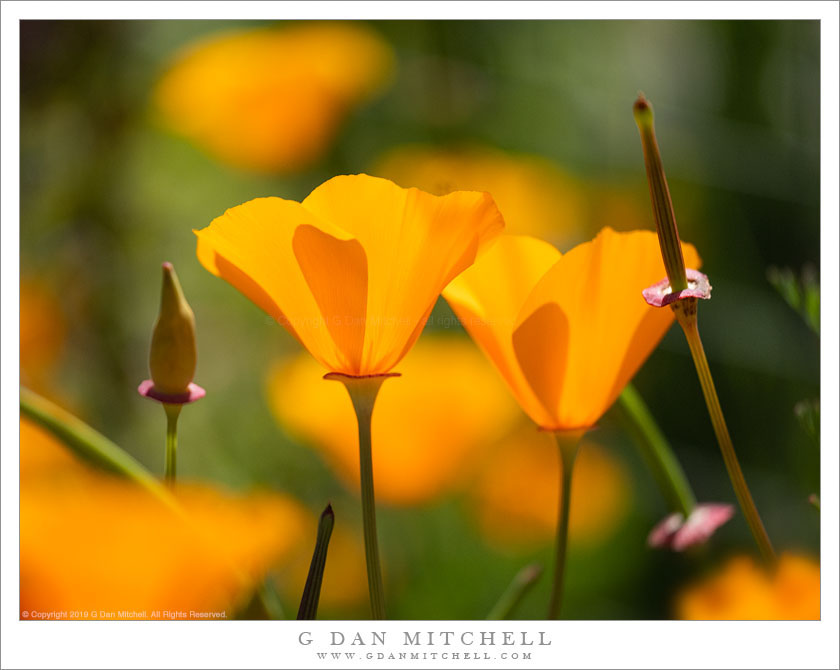
Tag Archives: two

Two Tidy Tips Flowers

Two Tidy Tips Flowers
Two tidy tips flowers, San Luis Obispo County, California

Two Tidy Tips Flowers. © Copyright 2019 G Dan Mitchell – all rights reserved.

Two tidy tips flowers, San Luis Obispo County, California.

How could anyone not like this flower?! It is easy, I think, to take some flowers for granted, but the color pattern of this flower is wild and quite striking. I photographed this pair near the beginning April in San Luis Obispo County, where we had gone for one day of photography in its landscape of grasslands and oaks.

News reports, of course, seem to highlight a very small number of supposedly “special” wildflower locations each year. In fact, some of those places can be pretty special. But they are hardly the only great locations for finding California spring wildflowers! In truth, you can almost certainly find great displays within an easy day’s drive from wherever you live in the state, and in many places you can find them even closer.


G Dan Mitchell is a California photographer and visual opportunist. His book, “California’s Fall Color: A Photographer’s Guide to Autumn in the Sierra” is available from Heyday Books and Amazon.

Blog | About | Flickr | FacebookEmail

Links to Articles, Sales and Licensing, my Sierra Nevada Fall Color book, Contact Information.


All media © Copyright G Dan Mitchell and others as indicated. Any use requires advance permission from G Dan Mitchell.

Hikers, Desert Canyon

Hikers, Desert Canyon
Two hikers entering the narrows of Titus Canyon

Hikers, Desert Canyon. © Copyright 2019 G Dan Mitchell – all rights reserved.

Two hikers entering the narrows of Titus Canyon.

The stream beds of desert washes often seem to me to be the “freeways” of the desert. They can (but not always!) provide relatively easy walking through rougher terrain. The periodic flow of water, along with the mud and rocks caught in its flow, both clears the washes of vegetation and leaves a relatively flat surface of small stones and dried sediment. Over millennia the water flowing through the washes does the hard word of trail building, wearing down obstructions and leveling out the rough places. (OK, there are exceptions — those chock stones that fall into canyons and block them, along with the periodic “dry falls” that may be unsurmountable.)

This canyon is often used by motor vehicle traffic, but following heavy rains that made the route impassable to vehicles it turned into a much more pleasant place to hike, and a group of us walked up through the spectacular narrows in its lower reaches. Lower in the canyon it is sometimes quite narrow, though in this location it begins to broaden a bit. To understand the scale of the terrain look closely and you’ll be able to spot a couple of hikers.


G Dan Mitchell is a California photographer and visual opportunist. His book, “California’s Fall Color: A Photographer’s Guide to Autumn in the Sierra” is available from Heyday Books and Amazon.

Blog | About | Flickr | FacebookEmail

Links to Articles, Sales and Licensing, my Sierra Nevada Fall Color book, Contact Information.


All media © Copyright G Dan Mitchell and others as indicated. Any use requires advance permission from G Dan Mitchell.

Two Hikers, Titus Canyon

Two Hikers, Titus Canyon
Two hikers descending the narrows of Titus Canyon

Two Hikers, Titus Canyon. © Copyright 2019 G Dan Mitchell – all rights reserved.

Two hikers descending the narrows of Titus Canyon.

Earlier this month I visited Death Valley National Park for a few days. I go there and photograph at least once each year — I’ve been visiting for a couple of decades and photographing the place seriously for about fifteen years. I often point out that there are few places where the effects of water are more obvious than in this unlikely location. Almost all features of the park are formed or sculpted by water, and these effects are very visible in the early bare desert landscape. I arrived only a day after extremely heavy rains, and the evidence was everywhere — flooded sections of roadway, wet and muddy washes, dunes that were still damp, large shallow lakes on playas.

Many park roads were closes, including the long dirt road through Titus Canyon. The road starts high in Amargosa Canyon, crosses the mountains, descends toward the Valley, and near the end passes through a section of very narrow canyon. Normally there is enough traffic there to interrupt the reverie of hikers, but the road was closed to vehicle traffic and we (some members of my family) and I enjoyed a long and quiet hike up the canyon. Here two hikers (my sister and her husband) are descending though one of the deeper and narrower sections of the canyon.


G Dan Mitchell is a California photographer and visual opportunist. His book, “California’s Fall Color: A Photographer’s Guide to Autumn in the Sierra” is available from Heyday Books and Amazon.

Blog | About | Flickr | FacebookEmail

Links to Articles, Sales and Licensing, my Sierra Nevada Fall Color book, Contact Information.


All media © Copyright G Dan Mitchell and others as indicated. Any use requires advance permission from G Dan Mitchell.

Water Tanks, Mountains and Plain

Water Tanks, Mountains and Plain
Two abandoned water tanks at Carrizo Plain National Monument in spring

Water Tanks, Mountains and Plain. © Copyright 2019 G Dan Mitchell – all rights reserved.

Two abandoned water tanks at Carrizo Plain National Monument in spring.

These old and apparently abandoned water tanks sit over a small seasonal stream a good distance up above the floor of the Carrizo Plain. You would think that the purpose of the tanks would be obvious, but I’m not so sure. I did a bit of (less-than-diligent) research to try to discover their purpose, but what little I came up with seemed to have less of the character of being based on primary sources and more than of something reportedly heard by someone who was told something by someone who thought they remembered that… You get the picture. I can think of two possibilities. As some sources report, they could have been built to ensure a year-round water supply for cattle operations. It also seems possible that they could have been connected to resource extraction operations, such as those at Soda Lake.

The presence of the tanks is a reminder that this landscape (like most landscapes, to be honest) has a strong human element — it isn’t exactly wilderness! When people visit the Carrizo today they most likely come to see the natural phenomenon of the springtime wildflowers. But the place has been shaped by oil exploration and (nearby) extraction, cattle ranching, “mining” of various sorts, and more. All of that aside, the backdrop for these remnant structures, especially on a spring day when rain showers alternated with sunshine, is an immense and spectacular landscape.


G Dan Mitchell is a California photographer and visual opportunist. His book, “California’s Fall Color: A Photographer’s Guide to Autumn in the Sierra” is available from Heyday Books and Amazon.

Blog | About | Flickr | FacebookEmail

Links to Articles, Sales and Licensing, my Sierra Nevada Fall Color book, Contact Information.


All media © Copyright G Dan Mitchell and others as indicated. Any use requires advance permission from G Dan Mitchell.