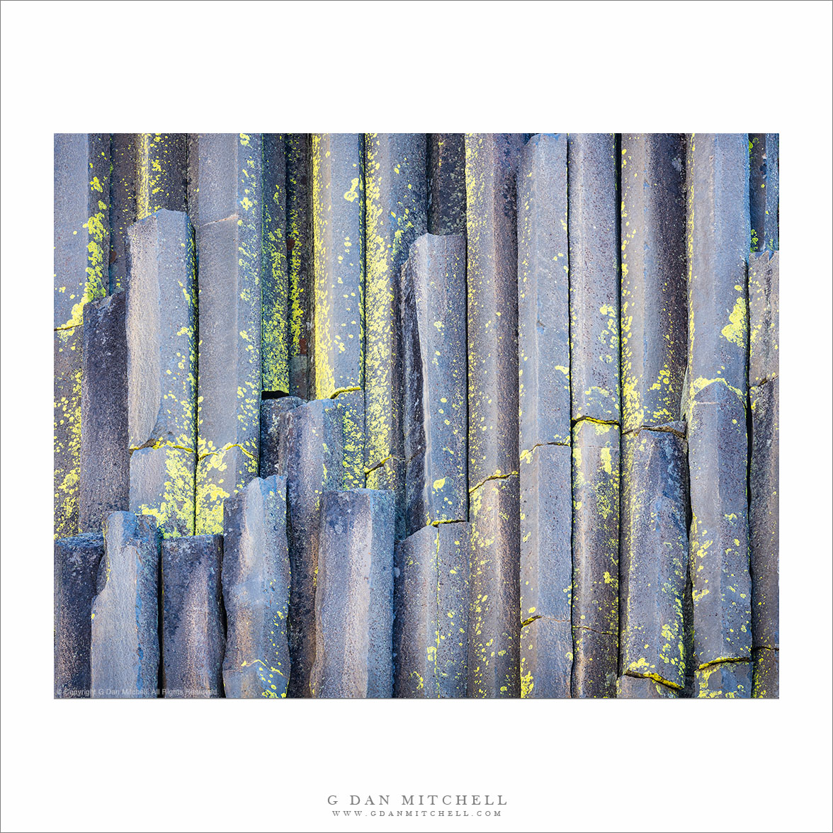
“Basalt Columns and Lichen” — Yellow lichen growing on the basalt columns of Devils Postpile National Monument
This is one of several photographs I made of the Postpile on this autumn morning, and every time I post one more I get to tell a bit of a story on myself. Landscape photographers often get up very early, sometimes many hours before sunrise. On this morning we had plans to do just that, and if we had gotten up on time we would likely have gone of to photograph aspens somewhere. But we overslept! It had been a long week, the drive to the east side of the range the evening before had been a long one, and we had arrived late. So rather than waking up hours before sunrise, it was probably more like an hour after sunrise.
We were initially a bit disappointed at losing a sunrise, but we decided to just take it easy, and soon we sat down to a nice civilized breakfast — also something of an anomaly for early morning photographers. Eventually we decided to wander out and just go up to Devils Postpile, which wasn’t far away. Arriving well after the supposed good light, I was going to just leave my camera equipment in the car, but Patty persuaded me to take it. And was I glad I did. Here the sun rises behind the face of the postpile, which was still in shadow, though receiving some reflected light from behind us and from the blue sky. I had a short time to work in this lovely soft light before the sun finally peeked over the top and I found myself photographing straight into its light.
Morning clouds and haze over Mono Craters, as seen from the upper elevation of Lee Vining Canyon.
East of Tioga Pass, highway 120 (a.k.a. “Tioga Pass Road”) descends relatively gently past Tioga Lake and then Ellery Lake before it drop precipitously down the eastern escarpment of the Sierra Nevada through Lee Vining Canyon on its way to the junction with highway 395 just south of the town of Lee Vining. I’ve driven over it for years, going back and forth between my home in the San Francisco Bay Area and the east side of the Sierra, so I should be fairly nonchalant about it by now – but every so often as I pass over the route (most often looking down into the canyon from above) I wonder whatever possessed people to think that it would be a good idea to route a road across the talus fields and across the steep headway of this canyon.
During last week’s photographic trip to the Tuolumne Meadows area of Yosemite National Park I went over the pass twice. The first time was to scout out some possible shooting locations around Mono Lake – OK, and to get an espresso at Latte Da in Lee Vining – and the second was the following morning when I returned to shoot one of these locations. The night before I had moved my camp to Ellery Lake (it is a long story), which put me a bit closer to Mono Lake, so I was up well before dawn and at the lake before sunrise. After photographing my primary subject there right at dawn, I stuck around long enough to photograph the early morning light and haze above the lake, then headed back to break up my camp before heading home. As I crossed that headwall high up above Lee Vining Canyon, I looked east toward the Mono Craters. Looking that way is pretty much a habit, but I rarely find it to present anything that I want to photograph. This morning was different. I quickly found a turn-out and drove back to this spot. A nice haze filled the air (I like atmospheric haze for photography!), a few clouds clustered around ridges just beyond the volcanic Mono Craters, and a high line of clouds from monsoonal flow were in the far distance, with the steep walls of Lee Vining Canyon backlit and almost seen entirely in silhouette.
G Dan Mitchell is a California photographer whose subjects include the Pacific coast, redwood forests, central California oak/grasslands, the Sierra Nevada, California deserts, urban landscapes, night photography, and more. Blog | About | Flickr | Twitter | Facebook | Google+ | 500px.com | LinkedIn | Email
Basin Mountain and the Sierra Nevada crest rise above Round Valley on a hazy afternoon.
There is a certain kind of afternoon light in the eastern Sierra that is hard to photograph – looking up at the range from Owens Valley into the afternoon sun the haze can be bluish and decrease detail and the light can be very bright. But it is a part of the experience of the “east side” that we all know, I think. I can’t say that I’ve tried to photograph it very often, but I stopped just off of highway 395 in the Round Valley area on this early October afternoon when I saw the rugged foothills rising above the sagebrush towards the Buttermilks and Basin Mountain and the Sierra crest around Mount Humphreys beyond.
For me, this is one sort of classic eastern Sierra view. Imagine a very warm or even hot afternoon. You are driving through high desert sagebrush country – which often surprises people who are headed to the Sierra and are thinking about high mountains and cool temperatures. The mountains to the west rise precipitously from the floor of Owens Valley, with peaks that can be nearly 10,000 feet higher than the lowlands in some places. You see snow on the peaks and sometimes on the slopes of the mountains. You know that there are places up there where you can park a car and walk out in cool mountain air and head up a trail through meadows and forests and cross a ridge into the alpine world – but the terrain gives little hint of this from below. The light gleaming on snow fields and rock projected into the sky reminds you of this other world high above.
This photograph is not in the public domain and may not be used on websites, blogs, or in other media without advance permission from G Dan Mitchell.
The north shoreline of Mono Lake leads from foreground offshore tufa past the base of Black Point to Negit Island and beyond.
You would never know it from this black and white photograph of the austere desert landscape around Mono Lake, but I was there to photograph… fall aspen color! Earlier in the day I had photographed further south along the eastern slopes of the Sierra, gradually working my way north with a plan of heading back to the “west side” over Tioga Pass at the end of the day after doing a last bit of fall color photography near Conway Summit and Dunderberg Road in late-afternoon light. By mid-afternoon I had made it to Lee Vining for an espresso stop at Latte Da and a break to check some email and so forth. Soon it was time to get into position for the low angle sun that would light the aspens a bit later, so I headed north out of town.
The road north from Lee Vining skirts the west shore of Mono Lake. Before leaving the lake there is a turn-off to another road that passes along the north shore of Mono Lake and can take you to places such as Black Point. I often stop at this turn-off since it provides a slightly elevated view of the larger terrain around the lake including the low hills to the east and Mono Craters and higher mountains to the south. On a typical blue sky mid-afternoon I might not make any photographs, but something about the light and the forms of the shoreline, Black Point, and Negit Island leading into the distance convinced me to make a few exposures, using a long lens to compress the distance.
This photograph is not in the public domain and may not be used on websites, blogs, or in other media without advance permission from G Dan Mitchell.
Photographer and visual opportunist. Daily photos since 2005, plus articles, reviews, news, and ideas.
Manage Consent
To provide the best experiences, we use technologies like cookies to store and/or access device information. Consenting to these technologies will allow us to process data such as browsing behavior or unique IDs on this site. Not consenting or withdrawing consent, may adversely affect certain features and functions.
Functional
Always active
The technical storage or access is strictly necessary for the legitimate purpose of enabling the use of a specific service explicitly requested by the subscriber or user, or for the sole purpose of carrying out the transmission of a communication over an electronic communications network.
Preferences
The technical storage or access is necessary for the legitimate purpose of storing preferences that are not requested by the subscriber or user.
Statistics
The technical storage or access that is used exclusively for statistical purposes.The technical storage or access that is used exclusively for anonymous statistical purposes. Without a subpoena, voluntary compliance on the part of your Internet Service Provider, or additional records from a third party, information stored or retrieved for this purpose alone cannot usually be used to identify you.
Marketing
The technical storage or access is required to create user profiles to send advertising, or to track the user on a website or across several websites for similar marketing purposes.