Category Archives: Photographs: Southern California

Natural Bridge Canyon

Natural Bridge Canyon

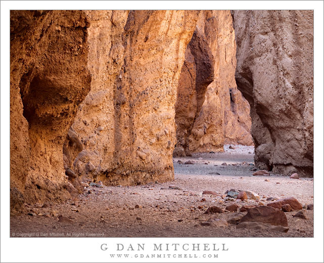
Natural Bridge Canyon. Death Valley National Park, California. March 27, 2010. © Copyright G Dan Mitchell – all rights reserved.

A gravel wash in the bottom of the narrow confines of Natural Bridge Canyon, Death Valley National Park.

These narrow canyons, of which there are a number of great examples in Death Valley, can provide some interesting photographic opportunities, but they also can pose some real challenges. Much of the rock in these places is, frankly, rather drab and of low contrast. However, at the right time of day and on a day with the right light and in the right parts of these canyons, the glowing light reflected down into the canyons from overhead rock walls can produce warm and diffused light and bring interesting colors to the place.

I made an unusual decision to use a very long focal length for this photograph – it was shot with a 100-400mm zoom at 330 mm. More typically I would probably tend to use wide angle focal lengths in the confines of such a canyon. However, because I wanted to juxtapose the different colors and shapes of the sections of canyon wall along the narrow and twisting wash, I chose the long lens to compress the distance. Although I think the photograph creates a feeling that I’m positioned very close to the foreground rocks and the darker bit of canyon wall on the left, I was actually quite a distance back from this spot.

G Dan Mitchell Photography
About | Flickr | Twitter | Facebook | Google+ | 500px.com | LinkedIn | Email

Text, photographs, and other media are © Copyright G Dan Mitchell (or others when indicated) and are not in the public domain and may not be used on websites, blogs, or in other media without advance permission from G Dan Mitchell.

(Basic EXIF data may be available by “mousing over” large images in posts. Leave a comment if you want to know more.)

Rugged Terrain, Lower Titus Canyon

Rugged Terrain, Lower Titus Canyon

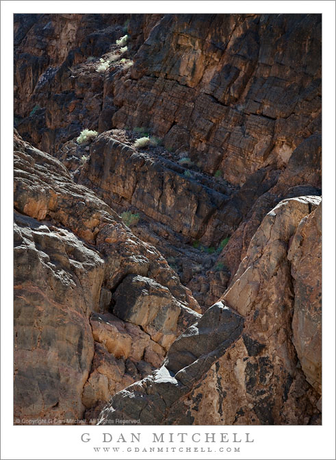
Rugged Terrain, Lower Titus Canyon. Death Valley National Park, California. March 28, 2010. © Copyright G Dan Mitchell – all rights reserved.

Details of the rugged cliffs and walls rising above lower Titus Canyon in Death Valley National Park.

Titus Canyon Road is one of the marvels of Death Valley National Park. It begins in high desert of Amargosa Valley near the town of Beatty and the ghost town of Rhyolite, winds over the summit of the Grapevine Mountains, drops precipitously into upper Titus Canyon, passes a number of historically interesting sites, passes through a very narrow and deep section in the lower canyon, and then suddenly emerges into the vastness of Death Valley.

In the lower section of the canyon, the wash becomes very narrow, passing through a twisty slot canyon and is, in places, barely wide enough for the one-lane gravel road. Here the walls of the canyon press tightly together and rise steeply for hundreds of feet. Some places are so deep that the sun rarely penetrates to the bottom.

Fortunately for the preservation of the canyon the road is horrible, at least if you are used to more civilized driving. It is a one-way road and the whole thing is gravel. Sections are in decent shape, but it other places the road passes over narrow and twisty sections next to precipitous drop-offs and then dives steeply into deep canyons. At times the route is closed after heavy rains or other conditions that make the route impassable.

Fortunately, the section that is perhaps the most impressive in many ways – the deep slot canyon near the bottom – is easily accessible by foot from Death Valley. After a short drive up to the canyon entrance on a gravel road to a parking area, you can enter the canyon on foot and walk up as far as you want. This photograph was made within the lower mile of the canyon during the late morning, when the light penetrates more deeply into the canyon and creates a glow on the canyon walls.

G Dan Mitchell Photography
About | Flickr | Twitter | Facebook | Google+ | 500px.com | LinkedIn | Email

Text, photographs, and other media are © Copyright G Dan Mitchell (or others when indicated) and are not in the public domain and may not be used on websites, blogs, or in other media without advance permission from G Dan Mitchell.

(Basic EXIF data may be available by “mousing over” large images in posts. Leave a comment if you want to know more.)

Two Hikers at the Summit of Death Valley Dunes

Two Hikers at the Summit of Death Valley Dunes

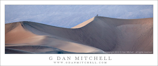
Two Hikers at the Summit of Death Valley Dunes. Death Valley National Park, California. © Copyright G Dan Mitchell – all rights reserved.

Two hikers take in the evening landscape of Death Valley National Park from the Summit of the dunes.

Many times I might have been disappointed to have two hikers enter “my” scene in such beautiful dusk light, but here I feel like they crystalize the scene. In a larger version of the photograph the two of them seem to stand silently facing the rugged vastness of Death Valley – and I think their presence invites us to think of ourselves in the scene and to imagine our own reaction to it.

My favorite time to photograph these iconic dunes near Stovepipe Wells is in the evening during a brief interval right around sunset and lasting a while after the sun drops behind the peaks to the west. The light softens, especially if there is a bit of haze in the sky, and the dunes that are so bright and harsh at other times of day take on a smoother and softer quality and their subtle colors become visible.

This photograph is not in the public domain and may not be used on websites, blogs, or in other media without advance permission from G Dan Mitchell.

G Dan Mitchell Photography
Flickr | Twitter | Facebook Fan Page | Facebook | Friendfeed | Email

Morning Clouds Above the Manifold, Zabriskie Point

Morning Clouds Above the Manifold, Zabriskie Point

Morning Clouds Above the Manifold, Zabriskie Point. Death Valley National Park, California. April 2, 2007. © Copyright G Dan Mitchell – all rights reserved.

Morning clouds fill the sky above the Manifold at Zabriskie Point, Death Valley National Park.

I posted a monochrome version of this photograph yesterday, so there is perhaps a bit less to say about it in this post. To recap briefly, this is a photograph I made over three years ago during a spring visit to Death Valley NPS. This was a bit of a different morning for photographing at Zabriskie Point, if I recall correctly. Usually, photographing here is pretty straightforward – and once you’ve shot it a couple times in “normal” conditions, there is a basic pattern to the progression of light that becomes fairly (though perhaps not totally) clear. Normal conditions here basically mean perfectly clear skies with the sun coming up to the left from the perspective of this photograph or behind in some of the other familiar shots that include Manley Beacon – and light that sequentially illuminates subjects beginning with the highest peaks of the Panamint Range across the Valley and gradually working down into the Valley and finally to the rugged shapes at Zabriskie Point itself.

But clouds can change everything. If I am going to shoot at Zabriskie, I watch for conditions that will bring them. I will generally not stop there if it is “another beautiful clear sunrise” at Zabriskie. (If you haven’t been there before, you should stop and take in this stunning scene, but I’m often looking for something a bit different.) While the results in clear conditions are relatively predictable, they are not at all as predictable when there are clouds. You can end up with something very special… or with a drab, flat, and gray scene. But that’s the thing about special conditions – they wouldn’t be special if they were predictable and frequent!

Thinking back to this morning, my recollection is that it may have been one of those when I arrived to think, “Oh, boy, clouds!” – only to think a bit later, “I wish those clouds would move and give me some light!” I recall some bits of dawn light that were mostly blocked by the clouds. But the very clouds that blocked the hoped-for first dawn light thoughtfully assembled themselves into these impressive forms just a bit later, at right about the time that the warm side-light was getting down into the rugged folds of the Manifold and Gower Wash.

This photograph is not in the public domain and may not be used on websites, blogs, or in other media without advance permission from G Dan Mitchell.

G Dan Mitchell Photography
Flickr | Twitter | Facebook Fan Page | Facebook | Friendfeed | Email